


Please enter the answer below before you can view the full text.
8+7=
This paper firstly obtains the formula of the scintillation index for weak and strong turbulence channels on the basis of the power spectrum function of oceanic turblance refractive index and strong fluctuation theory. Then, the average bit error rate (BER), average channel capacity, and outage probability of the oceanic wireless optical communication system are deduced based on the unified Málaga model. The numerical results show that fluctuations in temperature and salinity always have a significant effect on the scintillation index. When the average temperature of seawater is over 20 ℃, the variation of local average temperature has little effect on the scintillation index. The average BER, average channel capacity, and outage probability performance of the wireless optical communication system under strong turbulent channel are worse than that in the weak turbulent channel, and it can be considered to be the strong turbulent channel if the inner scale is less than 0.001 m.
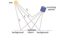
Based on the theory of light wave propagation in the atmosphere, the imaging process of a space-based optical system in a slant atmospheric path is simulated, the influence of atmospheric turbulence on imaging quality under different conditions is analyzed, and the simulation results are compared with theoretical ones. The simulation results show that when the system aperture is smaller than the atmospheric coherence length, the resolution increases significantly as the aperture enlarges. While the system aperture is larger than the atmospheric coherence length, the resolution tends to be stable gradually as the aperture increases, and the optimal aperture is about 2r0 (r0 refers to the atmospheric coherence length). Through the simulation of structure constant models with different refractive indexes, it can be seen that as transmission distance increases, the minimum resolvable length improves gradually. However, when the transmission distance reaches 50 km, the length tends to be stable. Therefore, when the transmission distance is below 50 km, atmospheric turbulence has a great impact on the imaging quality of the optical system. In addition, weak atmospheric turbulence will affect the ground resolution of the optical system at a degree of 2-3 cm, while strong atmospheric turbulence will affect that at a degree of 7-10 cm. Furthermore, the high-altitude turbulence in the tropopause can greatly affect the imaging quality. If the influence of the high-altitude turbulence is ignored, the resolution can be improved by about 1.4 times.
The Doppler asymmetric spatial heterodyne interferometer, a new type of mid- and upper-atmospheric wind-field detection system, can achieve atmospheric wind-field measurement by the inversion of the Doppler shift of observed source spectra after calculating the changes in interferograms. The reference phase is a necessary parameter to determine the Doppler shift of the wind field, and its stability is one of the core indicators to ensure the accuracy of wind speed measurement. This paper investigates three factors that affect the reference phase of an interferometer, namely, the phase drift of asymmetric quantities, phase slope drift, and phase drift of interferograms. Moreover, the theoretical analysis of the thermal phase drift is carried out on the basis of the principle of Doppler asymmetric spatial heterodyne interference. The separating and testing method for the phase-drift quantities of each factor is proposed, and the experimental test is conducted by the near-infrared Doppler asymmetric spatial heterodyne interferometer. Under the ambient temperature fluctuation of 0.27 ℃, the change of phase slope is 670 mrad/m, and the phase-drift fluctuation range of interferograms is 8.9 mrad. Upon the phase-drift correction of interferograms, the phase drift of asymmetric quantities is about 4.7 mrad, and the root mean square is 0.98 mrad, with the equivalent wind speed measurement error of 0.81 m/s. According to the bias experiment on temperature, the rate of phase-drift change of asymmetric quantities with temperature is -493 mrad/℃.
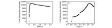
The algal multiphase transient chlorophyll fluorescence kinetic curve (also known as the OJIP curve) is employed to extract differences in distance, shape, and angle features, and curve differences are thereby measured. The K-nearest neighbor (KNN) classification algorithm is used to evaluate those features and select the combination of features with a better classification effect. Weights are assigned according to the contribution rates of different features to toxicity intensity characterization for feature fusion, which is followed by the construction of the characterization parameter PIFCD of the comprehensive toxicity of water. Moreover, Chlorella vulgaris is adopted as the test algae species to compare PIFCD with the current characterization parameters Fv/Fm and PIABS under the stress of toxic substances (DCMU, DBMIB, MV, Malathion, and Carbofuran). The effectiveness and superiority of the proposed parameter PIFCD are verified from the aspects of toxicity response, minimum detection limit, and maximum response concentration. The results show that PIFCD is sensitive to all the five toxic substances and can detect more kinds of pollutants than Fv/Fm. The minimum detection limits of PIFCD for the five toxic substances are respectively 90.34%, 41.66%, 81.91%, 95.43%, and 77.66% lower than those of PIABS. PIFCD also demonstrates a higher detection ability for high-concentration toxic substances.
This research adopts 532-nm and 1064-nm laser sources to study laser-induced cavitation bubbles and their time evolution and the spectra of laser-induced plasma emission in bulk water, respectively. The effects of laser wavelength and focus position of the focusing lens on cavitation bubbles and spectral intensity are discussed in detail. The results show that under the same experimental parameters, laser-induced cavitation bubbles have two periods of expansion-contraction oscillation in both cases. Nevertheless, cavitation bubbles produced by the 1064-nm laser have larger diameters and higher expansion speeds, and their intensity of laser-induced breakdown spectroscopy (LIBS) reaches 2.3 times that in the case of the 532-nm laser. Spectral intensity, cavitation bubble size, and their stability are closely related to the focus position of the focusing lens. A focus 10-12 mm below the water surface can not only produce cavitation bubbles with larger diameters and favorable stability, but also reduce the relative standard deviation of the spectral line intensity of LIBS from 20% to 13% and thereby improve the stability of the intensity.
Based on the aerosol optical inversion data from AERONET SGP station, an aerosol classification model based on a naive Bayesian classifier is proposed. The single scattering albedo and complex refractive index of aerosol are used as input variables to identify five types of aerosols in this region, and the optical properties of different types of aerosols are analyzed. The proposed model generates a classifier model based on the classification probability distribution of the training sample sets, and then predicts the classification of the test sample sets. On this basis, the proposed model is used to analyze the seasonal distribution difference characteristics of the aerosol types at the SGP station, and the experimental results are consistent with the climatic environment characteristics of this region. In order to verify the accuracy of classification results of the proposed model, the aerosol classification threshold standards are established by using the matching method combining AERONET station data and high spectral resolution lidar profile data. The results show that compared with the traditional aerosol classification algorithm, the aerosol classification results obtained by the proposed model have a high consistency with the results determined based on threshold criteria, which can provide ground data support for aerosol inversion by remote sensing equipment such as satellites.
There are many reports regarding the impact of temperature (T) on the absorption coefficient of pure water [aw(λ)] in the literature, and some of them are not consistent. In this study, using well-controlled measurements of remote-sensing reflectance [Rrs(λ)] of highly turbid waters where the temperature varied from 7 to 51 ℃, we analyzed the changes in the shape of Rrs in the 740-850 nm domain, especially the relationship between this change in Rrs spectral shape and the change of spectral shape in aw(λ) caused by temperature variations indicated by the latest laboratory measurements from Rottgers et al. We found that the twist of Rrs spectral shape in the 740-850 nm domain can be well explained by the twist of spectral shape in aw(λ) caused by changes in temperature. Since the spectral shape of Rrs in the near infrared (NIR) is mainly driven by the spectral variation of aw(λ), the consistency provides an independent verification of the spectrally-opposite temperature dependence of aw(λ) for bands in the 740-850 nm domain that was obtained from laboratory settings.
Due to the complex optical path, it is difficult to ensure the multi-optical axis consistency of the compound laser communication system that includes functions of nutation, adaptive optics, and fine tracking when the environment temperature changes, which leads to the drifts of wavefront correction benchmark and tracking zero position and seriously affects the establishment of communication links. In order to solve the above problems, this paper designs an integrated system, proposes a method for analyzing the multi-optical axis consistency of the complex optical path, and establishes an error propagation model of multiple reflective mirrors. After calculation, it is found that when the environment temperature ranges from 10 ℃ to 30 ℃, the coaxial errors between the fine tracking path and the communication path, between the communication launching path and the communication receiving path, and between the fine tracking path and the adaptive optics path are less than 143.77 μrad, 27.38 μrad, and 131.66 μrad, respectively. The 30 ℃ temperature adjustment experiment is carried out in the laboratory, and the experimental results show that the error between the actual and simulated deflection angles of the optical axis is less than 13%. Furthermore, a laser communication experiment (at 28 ℃) with a linear distance of 1 km between buildings is carried out to realize stable communication.
The sea environment is complex, and the lidar installed on the unmanned surface vehicle will generate various useless clutters in the process of detecting the target near our vehicle. And the useless clutters will affect the detection and tracking process and threaten the safety of the unmanned surface vehicle in the process of autonomous voyage. Therefore, it is necessary to effectively filter out all kinds of useless clutters generated by lidar on the sea. In this paper, the data association between the lidar and panorama camera is carried out to achieve the pixel-level registration of 3D point clouds and panoramic images in 2D images. According to the association results of the two kinds of data and the detection of target ships on the panoramic image, the three types of point cloud clutters defined in this paper are filtered.
Taking unmanned aerial vehicle (UAV) swarm as an example, this paper analyzes the detectability of an air-space infrared detection system for the UAV swarm. Firstly, the UAV swarm flight process is divided into three phases, and its infrared radiation characteristics and imaging characteristics are modeled and analyzed in detail. Secondly, as dispersion characteristics of target imaging in the detection range modeling are considered inadequately, a noise equivalent flux density (NEFD) point target detection range model based on dispersion coefficient is established. In the meantime, in order to verify the effectiveness of the proposed model, different modeling methods and dispersion coefficient comparison methods are used to analyze the change of detection range with signal noise ratio (SNR) and the swarm speed. Simulation results show that the detection range of the proposed model is better than that of other models, and the detection range increases as the swarm flight speed and SNR increase. Furthermore, the dispersion coefficient varies with the detection range. The detection range obtained by the dispersion coefficient solution is superior to that obtained by other methods.
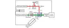
The calculation accuracy and time of the advance pointing angle are extremely important, which directly affect the tracking accuracy and debris ranging distance of a laser ranging system. When the optical angle measurement data of extremely short arcs is used for orbit determination, the sparse observation data often lead to non-convergence of orbit determination results, and thus it is impossible to calculate the accurate advance pointing angle using a traditional method. A new calculation method for advance pointing angles is proposed. Specifically, the data of the inertial sensor and optical detector carried on the satellite platform is used, and the angular velocity of relative motion is calculated by the data fusion algorithm based on the Levenberg-Marquardt algorithm. Then, the advance pointing angle is obtained by combining the relatively accurate distance information in orbit prediction. Under the working conditions of orbit determination using optical angle measurement data of extremely short arcs, the error of the proposed method is less than 0.1 μrad, and the minimum convergence time is 10 s, both of which are superior to those of the traditional calculation method and can meet the pointing accuracy requirements of the laser ranging system.
As scientists' requirements for the polarization accuracy continue to increase, the polarization accuracy of detection equipment becomes more and more important. Therefore, how to accurately measure the polarization characteristics of components and systems in order to optimize and improve the polarization measurement accuracy of the equipment is a key issue. In this paper, a mid-infrared Mueller matrix ellipsometer is designed and established, and the system is calibrated and tested by using the non-linear fitting method and the dual-rotating method at 12.32 μm wavelength. The results show that the measurement accuracy of the Mueller matrix of the ellipsometer is better than 0.02; the repeated measurement accuracy of the transmission sample and the reflection sample is 0.01 and 0.02, respectively. This study can provide reference for the design and application of mid-infrared Muller matrix ellipsometers.
In order to suppress the influence of ground environment disturbance and improve the calibration accuracy of the ground verification test of star sensors, a star simulation technology with the jitter compensation function is proposed. This technology uses a tunable laser as the light source to achieve a beacon light with jitter compensation. In addition, it employs a large-diameter beam-splitting prism to achieve a multi-target star map combination and a large-diameter high-precision piezoelectric deflecting mirror to give feedback on and compensate for starlight in real time. Furthermore, a long-focus collimator is utilized to provide stable stars for high-precision star sensors. The performance of the system is studied through simulation, and the results show that the compensation accuracy peak deviation is 0.045″, and the compensation resolution is 0.01″. Then, a star map simulation system based on the jitter compensation system is constructed, and the system is measured with a 4D interferometer. The results show that the compensation resolution of the system reaches 0.01″, with the compensation accuracy better than 0.1″. This technology can detect the slight deviation of the optical axis and perform high-precision compensation. It can also provide a stable star target for the ground verification system of the high-precision star sensor and offer a solution for subsequent systems that require a highly stable target source.
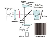
Co-phasing mosaic grating technology is an important method of manufacturing meter-sized echelle gratings, and the precision of piston error adjustment has a decisive influence on the mosaicking precision. To eliminate the periodic piston error in mosaic gratings and achieve the co-phasing mosaicking of large-size echelle gratings, the specific influence of the piston error on the point spread function of the mosaic gratings is analyzed theoretically. A piston error detection and adjustment method for grating mosaicking is proposed in light of the principle of interferometry. For this purpose, the Michelson interferometry system is utilized, and white light and two-wavelength measurement technologies are combined. Simulation calculation results of the piston change of interference fringes under different adjustment amounts are compared with the results of tests on the nano-translation stage. The calculation precision of the Fourier analysis algorithm is analyzed, and the precise piston error adjustment is achieved. The experimental results show that the piston error Δz of mosaic gratings achieved by the white light and two-wavelength measurement technologies is smaller than 6 nm, which means the proposed technology can meet the requirements of co-phasing detection of large-size mosaic gratings.
In terms of the disadvantage that contact air temperature detection is vulnerable to solar radiation and ground radiation, a remote sensing detection method of high spectral resolution lidar is proposed, and it is based on the Fabry-Perot interferometer which scans the scattering spectrum and conducts temperature retrieval, so as to realize the absolute measurement of air temperature. System parameter calibration is an important factor affecting the accuracy of temperature detection. Parameters such as driving voltage, full width at half maximum, free spectral range, and temperature control accuracy of the Fabry-Perot interferometer are calibrated by continuous laser. Through the calibration experiment, the corresponding voltage amplitude is 3.48 V at a frequency scanning range of 10 GHz; a temperature change of 0.1 ℃ at the Fabry-Perot cavity corresponds to the frequency drift of 0.21 GHz. The lidar temperature detection system is calibrated by using the scattering cell which can control the temperature and pressure. After the systematic error correction, the retrieval temperature is in good agreement with the preset temperature, which lays a foundation for accurate detection and retrieval of the actual temperature.
In terms of the large proportion and multidirectional rotation of small ship targets in remote sensing images, a small ship target detection method based on texture and color enhancement is proposed. Firstly, a generative adversarial network is designed to enhance the texture features of small ship targets and generate high-resolution ship images. Secondly, the deep reinforcement learning algorithm is used to improve the image color, which solves the problem of the low contrast between the ship target and the background color. Thirdly, an adaptive transform feature pyramid network is designed to enhance the global receptive field and effectively deal with the hard extraction of small target features, which is caused by the lack of spatial information in the deep network. Finally, the feature refinement module and circular smooth label are utilized to align feature points and achieve angle regression in a ship target bounding box, which effectively increases the accuracy of detecting ship targets with multidirectional rotation. In addition, related tests are carried out on the public data sets of HRSC2016 and DOTA, and results show that the proposed method achieves an mean average precision of 72.87% and 89.91%, respectively, which is better than the existing mainstream small ship target detection methods.
The polarized reflectance estimation of land surfaces is one of the most important uncertainties in the polarized remote sensing detection of atmospheric aerosol by satellites and thus becomes an important link in the land-atmosphere decoupling during aerosol inversion. The directional polarized measurements of atmospheric aerosol in the near-infrared band (865 nm) by a directional polarimetric camera (DPC) aboard the GaoFen (GF-5) satellite are spatiotemporally matched with the aerosol product AOD L2.0 of the sites of the worldwide ground-based aerosol monitoring website AERONET. Data corresponding to small aerosol optical depth (AOD) values are thereby screened out to reduce the influence of aerosol and further to obtain directional polarized reflectance data of the land surface. The performance of five semiempirical bidirectionally polarized reflectance distribution function (BPDF) models of land surfaces for eight typical land surface types is quantitatively compared using the DPC measurements. The models compared included the Nadal-Bréon model, the Waquet model, the Maignan model, the Litvinov model, and the Xie-Cheng model. The comparison shows that the results of the Litvinov and Nadal-Bréon models agree well with the DPC measurements. Specifically, the average correlation coefficients of the results of the two models with the DPC measurements reach 0.958 and 0.952, respectively, and the corresponding average root-mean-square errors (RMSEs) are 0.202% and 0.223%, respectively. The research results serve as a reference concerning BPDF models for polarized reflectance estimation of land surfaces with DPC data and provide prior data support for applications such as the inversion of aerosol parameters with DPC data.
The sea-land segmentation of remote sensing images has significance application value in applications such as coastline extraction, island reef identification, and near-shore target detection. However, it is prone to inaccurate sea-land boundary segmentation owing to the influences of complex and diverse background environment and the sea-land boundary. To address the aforementioned problem, a multi-scale sea-land segmentation network, namely MSRNet, for remote sensing images based on Res2Net is proposed in this paper. It uses a deep convolutional neural network named Res2Net to extract multi-scale features of images and applies a squeeze and attention module to enhance features at different scales to strengthen the weak sea-land boundary information. The enhanced feature maps at different scales are then upsampled to the original image size, and the prediction results at different scales are loss-enhanced using a deep supervision strategy. Two remote sensing image datasets containing complex scenes are selected for the experiments, and the results show that the proposed network can obtain more accurate sea-land segmentation results as well as clearer and more complete sea-land boundaries than other networks for various natural and artificial coastlines.
The traditional building extraction methods for classification and identification are susceptible to interference from the complex environment and can lead to false detection. As a result, the building contour is irregular and inconsistent with the actual shape. To solve this problem, a building contour optimization method based on the main direction is proposed. Firstly, according to the image and building features, the initial extraction results of a building are pretreated to remove non-building patterns and scattered line segments. Then, the main direction of the building is determined by considering its positive circumscribed rectangle, and it is used to reconstruct the building contour for the preliminary regularization result. Finally, the boundary characteristic strength is calculated with the initial result to further reduce the deviation after regularization, and achieve depth optimization of building contours. In addition, by comparing with other methods, the relevant parameters are discussed and analyzed. The result indicates that compared with other methods, this method can effectively improve the integrity and regularity of the initial result, and it can finely optimize the buildings with different sizes and complexity to obtain higher optimization accuracy. The proposed method can be used as a reference method for optimization after building extraction.
Horizontal detection fluorescence lidar is an effective tool to observe atmospheric organic aerosols, and the calibration of its system constants is the key to obtaining the concentration of organic aerosols with fluorescence echo signals by inversion. A calibration method for the system constants of horizontal detection fluorescence lidar based on the fluorescence-Mie scattering echo signal intensity ratio is proposed. The proposed method uses the fluorescence-Mie scattering echo signal intensity ratio attained by horizontal detection and the aerosol concentration data measured by the particle counter at fixed points to obtain the system constants of the lidar, and thereby reduce the influence of the system geometry factor. The accuracy and stability of the proposed method are verified by a comparison with the traditional calibration method in the numerical calculation. Its feasibility and effectiveness are proved by a practical calibration experiment with a fluorescence-Mie scattering dual-channel lidar for horizontal near-field detection. The results show that the proposed method not only can effectively reduce the influence of the geometrical factor on calibration accuracy, but also offers better stability.
Daytime and nighttime spaceborne lidar data from CALIOP Version 4.10 Level 1B and Version 4.20 Level 2 products are used to retrieve sea surface wind speed globally in October 2017, January 2018, April 2018, and July 2018. The quasi-synchronous sea surface wind speed observed by the Version 8.2 AMSR-2 product is selected for comparison. Based on the previous studies of sea surface wind speed which focused on the cloud-free data of CALIOP, the data of transparent cloud layers are further used for the retrieval of sea surface wind speed, and the retrieval accuracy maintaines the same level when the data is added significantly. The effects of differences between different sea surface slope distribution models on the retrieval of sea surface wind speed by CALLOP are explored. Furthermore, the Gram-Charlier approximation model with transparent cloud layers at daytime and nighttime is given. Results show that the Gaussian model has relatively small error, while the Gram-Charlier approximation model corrects the effect of kurtosis and skewness, and has better performance when wind speed is low (-1) or high (>13 m·s-1). According to results of the Gram-Charlier approximation model with transparent cloud layers, the standard deviations of nighttime data in October 2017, January 2018, April 2018, and July 2018 are 1.22 m·s-1, 1.33 m·s-1, 1.20 m·s-1, and 1.39 m·s-1, respectively, and the correlation coefficients are 0.92, 0.91, 0.92, and 0.90, respectively. The standard deviations of the daytime data are 1.41 m·s-1, 1.45 m·s-1, 1.86 m·s-1, and 1.69 m·s-1, respectively, and the correlation coefficients are 0.90, 0.89, 0.86, and 0.87, respectively.
The directional polarimetric camera (DPC) on the GaoFen-5 satellite is not equipped with an on-board calibrator, and thus it requires different alternative methods for the in-flight radiometric calibration. For this purpose, an in-flight cross radiometric calibration method is developed, and the real-time surface directional reflectance and spectral response differences are considered to realize the in-flight cross radiometric calibration of DPC/GaoFen-5 and MODIS(moderate-resolution imaging spectroradiometer)/Aqua. In this method, MODIS/Aqua with a high accuracy on-board calibration ability is selected as the reference sensor, and the observation data over the pseudo-invariant calibration site in North Africa is used. By inputting the real-time satellite bidirectional reflection product and calculating the atmospheric radiative transfer, this paper accurately corrects the apparent radiation deviation caused by the sun-observation geometry and spectral response differences between the two sensors and finally obtains the in-flight cross radiometric calibration coefficient of the sensor to be calibrated. Theoretical analysis results show that the calibration uncertainty of this method is 2.41%-3.70% at the non-absorption band of DPC. The preliminary results of the cross radiometric calibration between DPC/GaoFen-5 and MODIS/Aqua show that they have a good radiometric consistency, and the apparent radiation difference of each band is less than 4%.
A large number of suspended algal particles exist in the underwater channels, which has a significant impact on the transmission characteristics of laser signals. Therefore, by the generalized Mie theory, a model for the scattering of Laguerre-Gaussian (LG) vortex beams by underwater suspended spherical algal particles is built. Specifically, numerical simulations of the effect of a single suspended spherical algal particle on the scattering characteristics of LG vortex beams are conducted, and the influence of the particle radius, beam waist radius, vortex beam order and topological charge on the differential scattering cross sections of LG vortex beams is calculated. Then, the influence of the underwater suspended spherical algal particle swarms on the differential scattering cross sections of LG vortex beams is further discussed. The results indicate that in the case of a single underwater suspended spherical algal particle, the differential scattering cross section increases with the increase in the particle radius, vortex beam order and beam waist radius, and decreases with the increase in the topological charge of vortex beams. Regarding the underwater suspended spherical algal particle swarm, the differential scattering cross section increases with the increase in the vortex beam order and beam waist radius, and decreases with the increase in the topological charge of vortex beams.
Tunable diode laser absorption spectroscopy (TDLAS) technology is inevitably interfered by optical fringes, detector noise, and circuit noise during measurement, which results in large output fluctuations. The use of the Kalman filter to post-process the measurement results can effectively improve the measurement precision and anti-interference ability of the TDLAS system. This study focuses on the ratio g of the measured noise covariance σV2 to the process excitation noise covariance σW2 in the Kalman filtering algorithm. Starting with the fluctuation and the response time of the Kalman filter output, the comprehensive effect evaluation index R of the filter is obtained by assigning them different weights, and the comprehensive research on the relationship between R and g shows that the optimal g is 27. Moreover, the advantages of Kalman filtering in anti-interference and stability over smooth filtering and extended state filtering are verified by simulations. The Kalman filter with optimized parameters is applied in the TDLAS ammonia escape detection, and the measurement precision of concentration of NH3 with a volume fraction of 4.7×10⁻⁶, concentration of NH3 with a volume fraction of 108×10-6, H2O concentration, and temperature is increased by 3.54, 3.48, 3.00, and 2.80 times, respectively.
In this study, inversion models of phytoplankton pigment concentrations are built for the total chlorophyll a and seven diagnostic pigments (i.e., chlorophyll b, fucoxanthin, peridinin, 19'-hexanoyloxyfucoxanthin, 19'-butanoyloxyfucoxanthin, alloxanthin, and zeaxanthin). Specifically, given the field measured data of fluorescence excitation spectra, the feature representations of fluorescence excitation spectra are constructed, and the machine learning algorithm eXtreme Gradient Boosting (XGBoost) is employed to build these models. The validation indicates that the inversion models have good estimation accuracy, among which the inversion model of the total chlorophyll a has the highest accuracy (with the determination coefficient of 0.87, the mean absolute percentage error of 28.1%, and the root mean square error of 1.168 mg·m-3). In addition, these pigment inversion models are applied to typical sections of the East China Sea, and vertical distribution features of pigment concentrations are obtained.
In view of direct temperature inversion by broadband absorbance, the individual and comprehensive influence of spectral noise and spectral parameter error on temperature inversion accuracy at a temperature range of 300-2000 K by numerical simulation is analyzed. When only spectral noise exists, the noise with an amplitude of ±0.005 is taken as a minimum noise, and the spectral noise whose amplitude is increased from ± 0.005 to ±0.1 is added. When the noise amplitude is ±0.1, the maximum standard deviation of temperature is 46.58 K @ 1700 K. In order to make the standard deviation less than 10 K, the spectral noise amplitude should be controlled within ± 0.02. when only spectral parameter error exists, the spectral parameter error of calibrated strong absorption lines and uncalibrated weak absorption lines is set to 1% and 10%-50%, respectively, and the maximum standard deviation of temperature is 7.77 K @1300 K (an error combination of 1% and 40%). The line intensity error has the greatest influence on temperature inversion, and thus the calibrated error of the line intensity should be controlled within 1% as far as possible. When spectral noise and spectral parameter error coexist, spectral noise has a greater impact on the temperature measurement accuracy, and the absorption signal with a better signal noise ratio can reduce the influence of spectral noise in the actual measurement process.
Based on the photoacoustic spectroscopy technology, this paper constructed a simulation model of the H-type differential photoacoustic cell by finite element simulation, and the geometric parameters of the cell were optimized. In addition, the robustness to noise was guaranteed, and the sound pressure and quality factor were greatly increased. The paper chose NO2 as the target gas to verify the performance of the photoacoustic cell, and a low-cost 450 nm laser diode was used as the excitation light source to match the strong absorption line of NO2 and avoid photolysis. The experimental results show that the differential characteristic of the photoacoustic cell is consistent with the simulation results. Within the detection time of 5 s, the linearity between photoacoustic signals and different concentrations of samples reaches 0.999, and the minimum detection limit is 124×10-12, which meets the online detection requirements of NO2 in an atmospheric environment.