


Please enter the answer below before you can view the full text.


2025
Volume: 46 Issue 3
14 Article(s)

Identifying tree species is of strategic importance for forest monitoring, analysis and management, and is crucial for sustainable forestry development. Therefore, we propose a method for tree species classification based on individual tree segmentation from airborne LiDAR, following by using the three-dimensional geometric features of the segmented tree crowns. First, TIN filter and tree points normalization are used to generate the Crown Height Model (CHM). Based on the geometric characteristics of the tree crowns, parallel-line shape fitting is used to fit the crown shapes. Specifically, three basic geometric shapes (triangle, rectangle and arc) are used to fit the crowns of different tree species. For the same crown shape or combinations of shapes, parametric classification is employed. The proposed method is tested using datasets from two different sites in the Tiger and Leopard National Park in Northeast China. The results show that the average accuracy of tree species classification is 90.9%, with the best accuracy reaching 95.9%, meeting the requirements of rapid forestry surveys.
Jun. 29, 2025Vol. 46 Issue 3 109 (2025)
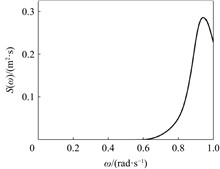
The complexity of Global Navigation Satellite System Reflectometry signals and the diversity of surface environments pose significant challenges to the retrieval of Vegetation Optical Depth (VOD). Traditional retrieval methods mainly rely on physical models and empirical formulas, which often fail to account for the nonlinear characteristics of complex surface conditions. To address this, the paper proposes a VOD retrieval method based on the eXtreme Gradient Boosting (XGBoost) algorithm, which utilizes the advantages of the high temporal resolution and high spatial coverage of Cyclone Global Navigation Satellite System (CYGNSS) data to enhance the adaptability of the retrieval model for complex surface conditions. The method uses CYGNSS feature parameters as inputs and Soil Moisture Active Passive VOD as reference outputs, optimizing model parameters through grid search and evaluating model accuracy using ten-fold cross-validation. Comparative analysis with Random Forest, Light Gradient Boosting Machine, Artificial Neural Networks, and K-Nearest Neighbors models demonstrates that the XGBoost model achieves the best retrieval accuracy, with a root mean square error of 0.002, mean absolute error of 0.030, and a correlation coefficient of 0.963. In addition, the CYGNSS VOD retrieved using XGBoost effectively reflects vegetation growth, with its distribution characteristics consistent with land cover types. The spatial correlation analysis with Enhanced Vegetation Index shows that over 80% of the areas have a correlation greater than 0.600. The proposed method demonstrates high accuracy and applicability, offering an effective approach for dynamic vegetation monitoring.
Jun. 29, 2025Vol. 46 Issue 3 147 (2025)
Jiapeng HAN, Xudong TONG, Shiqing WU, Huai XIE, Wei HUANG, Jiangli LEI, and Yang ZHANG
In view of the fact that the landing process of the re-entry capsule with airbags under wave conditions is not clear, based on the combination of a certain type of re-entry capsule with airbags, the corresponding multi-media coupling model is established by using the fluid-structure interaction algorithm, airbag simulation algorithm and wave simulation algorithm in related simulation calculation software. The water landing process of the re-entry capsule with airbags under two different wave conditions, sine regular wave and irregular wave, are numencally simulated, and the influence of different wave conditions under different working conditions on the peak overload, internal pressure and force of the return capsule is discussed. After analysis, it is concluded that the overload and the peak internal pressure corresponding to the irregular wave condition under the conditions of zero horizontal velocity and zero attitude angle are smaller than those under the influence of regular waves. Under the condition of horizontal velocity and attitude angle, the reverse acceleration process occurs when the horizontal velocity is large under the influence of regular waves, and the deformation and force distribution of the airbag system are also significantly different from those of irregular waves. The research results can provide a technical reference for the design and performance evaluation of offshore recovery systems.
Jun. 29, 2025Vol. 46 Issue 3 1 (2025)
Boyi TAN, Liuxin QU, Zhi LIU, Hexi BAOYIN, and Yao LI
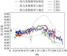
The high dynamic nonlinearity of the working process of the supersonic deceleration parachute brings great uncertainty to the modeling of the parachute, which affects the attitude stability analysis results of the parachute cabin combination. The influence of the front cabin on the aerodynamic force and moment coefficient of the parachute under supersonic inflow is simulated and analyzed in the paper, then the aerodynamic parameters of the single parachute based on CFD and wind tunnel test are modified. With the modified rear parachute force model as the input, the six degrees of freedom model of the front cabin under the action of deceleration parachute force is established. Based on the stability requirement of the attitude control of the front cabin, the damping control measures based on the Mach number and angular velocity threshold pneumatic roll channel are proposed. The experimental verification shows that the expected stable control of the attitude angular velocity of the forward cabin's roll channel is achieved in the initial stage of the supersonic deceleration section. At the same time, it also has a good suppression effect on the attitude angular velocity of the forward cabin's pitch and yaw channels.
Jun. 29, 2025Vol. 46 Issue 3 12 (2025)
Ming YAN, Zhiyong WANG, Junchao GENG, Ling LI, Peng AI, Guozhu SUN, and Chun WEI
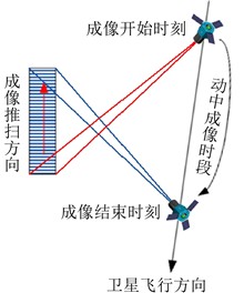
The BJ-3A satellite and the BJ-3B satellite are currently of the most imaging modes of high-resolution optical remote sensing satellite in China. Including the conventional multiple targets, stereo, tri-stereo, stripe mapping over large area, corridor acquisition modes in single pass, the BJ-3A/B satellites have the creative capacity of north-south direction active forward and reverse push-broom multiple contiguous stripes imaging mode. This article focuses on the characteristics of active forward and reverse push-broom imaging over large area with north-south stripes, a ground preprocessing flow of camera gear adjustment according to land cover and imaging mode, line during time normalization of reverse push-broom image, and high-order polynomial fitting and extrapolation for attitude parameters are designed to produce standard sensor corrected image product for active forward and reverse push-broom imaging mode. Taking the plane accuracy measurement of BJ-3B north-south 5-stripe forward and reverse push-broom digital orthophoto maps as an example, the sub-0.5m forward push-broom image can meet 1∶2000 scale plane accuracy requirement, and the sub-0.5m reverse push-broom image can meet 1∶5000 scale plane accuracy requirement.
Jun. 29, 2025Vol. 46 Issue 3 22 (2025)
Li WEN, Hongbo LIAO, Xiaoya WANG, and Di JIN
To improve the accuracy of on-orbit spacecraft monitoring, this article proposes a method based on functional expert knowledge for on-orbit spacecraft state monitoring. The method first extracts the physical model of key parameters, and obtains the pipeline style and dynamic fine monitoring threshold through first year of on-orbit telemetry. Taking the Hydrogen-nickel Battery and Solar Array Driver Assembly key parameters of a geostationary satellite power supply subsystem as examples, the functional state monitoring method is studied and verified. The verification results show that the dynamic pipeline threshold based on expert knowledge can significantly improve the monitoring accuracy, which is one order of magnitude higher than the traditional fixed threshold monitoring accuracy.
Jun. 29, 2025Vol. 46 Issue 3 32 (2025)
Changwen CUI, Suhui DONG, and Kaiyue SUN
As the core safeguard for stable operation of spacecrafts, the satellite power system has reliability that directly determines the sucess of orbit missions.Battery safety constitutes the ultimate line of defense during satellite energy crises.To evaluate power system security under abnormal conditions,a mathematical model for battery safety strategies has been developed,incorporating mechanisms such as over-voltage protection,current limiting, and hierarchical energy crisis management.And a hierarchical threshold calculation method for energy crisis is proposed. This model is integrated into the simulation framework of remote sensing satellite power systems. The developed approach enables real-time adjustment of satellite load, battery output current, and charging voltage based on battery status monitoring, while assessing the impact of energy crises under abnormal conditions. The results demonstrate that when battery state of charge falls below 15% or over-discharge protection is triggered, hierarchical management strategies can restore normal operations 1-2 orbital periods in advance. Hierarchical energy crisis management effectively shortens satellite energy anomaly persistence duration.
Jun. 29, 2025Vol. 46 Issue 3 42 (2025)
Junlei CHANG, Weizhi WANG, Haochuan LIU, Shoucheng PANG, Pengpeng LIU, Jian SUN, Di ZHANG, Bowei ZHANG, Jukui YANG, Ruimin FU, and Zhinan ZHANG
The cantilevered support for space mirrors is a design challenge in remote sensing devices. Traditional structures made of materials such as cast titanium and carbon-silicon carbide cannot simultaneously meet the requirements of high lightweight, high support stiffness, and unconventional configurations. In this study, a high lightweight 3D-printed titanium alloy structure with a lattice in the skin was adopted to support the suspended mirror in a remote sensing camera. First, topology optimization was used to obtain a concept design for the support structure. Based on this conceptual design model, the geometric model was reconstructed using Creo software for shell extraction. The lattice structure was then filled using specialized software, and a lattice-in-skin 3D-printed model was established. Finally the HyperWorks software is used for finite element analysis of the skin and lattice. Iterative optimization was performed on skin thickness, lattice size, and local reinforcements. The support structure was fabricated through 3D-printed additive manufacturing and validated for its effectiveness through the dynamic test and CMM (coordinate measuring machine) measurement. This proposed method effectively addresses the support issue of suspended, unconventional mirrors and provides a valuable reference for the design and application of 3D-printed titanium alloy structure in remote sensing devices.
Jun. 29, 2025Vol. 46 Issue 3 51 (2025)
Changju LIU, Jinlong JIAO, Zhen WANG, Xiangqian JIANG, Hong YANG, and Yubing LYU
In comparison with civil image sensors, those employed in aerospace applications exhibit superior precision, stability, reliability and durability. These sensors must be capable of withstanding extreme environmental conditions, including temperature, pressure and radiation, necessitating the use of specialised materials and intricate structures. Recently, image sensors for aerospace applications have undergone significant advancements, establishing themselves as a crucial component in a multitude of space missions. They have been aptly described as the "retina" of modern information systems, serving as the primary means of capturing images. This paper focuses on image sensors for aerospace applications. Through synthesizing domestic and international literature and related reports, it highlights the current research status of CCD and CMOS image sensors in a number of fields, including earth observation, aerial observation and spacecraft control. It also discusses the challenges and development trends of image sensors for aerospace applications.
Jun. 29, 2025Vol. 46 Issue 3 61 (2025)
Chao ZHANG, Huanhong CHEN, Yuhang CHEN, Ai ZHANG, and Jianbing KANG
Stepper motors are widely used in space optical remote sensing mechanisms. The driving circuit and the motor in traditional design correspond in quantity, in order to achieve the drive control of large-scale stepper motors, a large number of relays are required for signal switching. The design has the problem of excessive circuit scale and high cost. In addition, remote sensing mechanisms often need to be locked during the launch process, which is generally achieved through the holding torque of stepper motors. However, a large number of stepper motors are simultaneously powered, which can also lead to high power consumption in the camera subsystem. In order to realize the drive control and weak current locking function of large-scale stepper motors, this paper studies the drive multiplexing technology of multi-channel spaceborne stepper motor. The designed drive multiplexing circuit can realize time-sharing motion control and synchronous locking function for multi-channel stepper motors, and the locking current can be adjusted according to actual needs. For the designed drive multiplexing circuit, 10 stepper motors are selected for functional testing. The experimental results show that 10 motors can achieve time-sharing motion control function, and the power supply current is 3 A, which is the rated current value of the stepper motor. The 10 motors can achieve synchronous locking function and the power supply current during locking is 5 A at the modulation frequency of 100 kHz, while the average locking current of a single motor is 0.5 A, only 1/6 of the traditional single-phase locking current. Based on multi-channel spaceborne stepper motor drive multiplexing technology, not only can the motion of large-scale stepper motors be controlled, but also synchronous weak current locking function can be achieved, effectively reducing the power consumption of the system and improving the reliability of optical remote sensing launch process and in orbit operation.
Jun. 29, 2025Vol. 46 Issue 3 74 (2025)
Xin MO, Liu YANG, Gang HUANG, Huadong LIAN, and Zhe LIN
In order to protect ultra-precision machining, precision measuring instruments and other high-tech equipment against environmental vibration, the vibration isolation performance of centralized control and distributed control in six DOF is investigated and compared for a four-legged active vibration isolation platform with symmetrical layout. In this paper, a six DOF rigid body model and vibration transfer model is constructed, and the centralized control scheme and decentralized control scheme are given respectively, and the corresponding decoupling condition and vibration transfer function are studied. Furthermore, through the vibration transmission analysis, the parameter adjustment method of vibration frequency and damping coefficient in six DOF is derived. The effectiveness of the two control methods is verified by simulation experiment. The theoretical analysis and simulation results show that the centralized control can independently adjust the six DOF isolation performances, the isolation damping and stiffness in three linear-degree of freedom directions can be changed independently through 8 control gains, and independently adjust the isolation frequency of three angular-degree of freedom directions through other 6 control gains, so that the vibration rate power spectrum can be significantly reduced by 50% to more than 90%. Decentralized control is independent for each support foot, which is easier to debug and combine applications. It can independently adjust the isolation frequency and damping in three linear-degree of freedom directions through three groups of 6 gains, and the vibration isolation performance in three angular-degree of freedom directions can be adjusted through cross-correlation with linear-degree of freedom, so as to achieve a vibration rate power spectrum attenuation by more than 90%.
Jun. 29, 2025Vol. 46 Issue 3 84 (2025)
Kaisi WANG, Chujiang LIAO, Shengbo CHEN, Lisai CAO, and Zhuqiang LI
In order to promote the promotion and application of high-resolution data in provincial areas and meanwhile accelerate the construction of satellite application systems and industrial development, the high-resolution special project has successively established 34 provincial-level high-resolution centers nationwide since 2013, and deployed 89 provincial industrialization demonstration projects during 3 batches, promoting the construction of remote sensing application demonstration systems for various specific businesses in each province (autonomous region, municipality directly under the central government). This article systematically analyzes the "Annual Application Reports" of 34 provincial-level high-resolution centers since 2017, and sorts out the crop remote sensing product system that has been applied in practical business work, including satellite data used in product development, method models used, application areas, and crop types. Combining domestic and foreign crop remote sensing technologies and model methods, it explores the product characteristics and existing problems of provincial high-resolution centers in crop remote sensing applications, and puts forward suggestions for provincial high-resolution agricultural crop remote sensing applications from three aspects: remote sensing image selection, remote sensing technology methods, and application area scale.
Jun. 29, 2025Vol. 46 Issue 3 96 (2025)
Peng ZHANG, Yun HOU, Yuanshuai DONG, Li CUI, Lin HU, Yijie MA, and Chujiang LIAO
As the core field in the development of global renewable energy, wind power is accelerating the green transformation of energy structure. In the design and efficiency assessment of wind power systems, wind turbine height is a critical parameter that directly influences turbine performance and overall power generation efficiency. Therefore, accurately and efficiently estimating turbine height is significant for site selection, layout optimization and system operation of wind power projects. This paper proposes a wind turbine height estimation method that integrates deep learning and machine learning, based on high-resolution remote sensing imagery. The method first utilizes a structurally improved DeepLabv3+ network to achieve precise segmentation of wind turbine shadows, from which shadow contour features are extracted and shadow lengths are calculated. Subsequently, in combination with geometric variables such as solar elevation angle, solar azimuth angle, satellite elevation angle and satellite azimuth angle, both multiple linear regression and random forest regression models are constructed to estimate wind turbine height. To validate the accuracy and adaptability of the proposed method, a dataset covering various geographic environments and turbine types is constructed to reflect practical application scenarios under diverse conditions. Experimental results demonstrate that, compared to the multiple linear regression model, the random forest regression model achieves superior estimation accuracy and stronger generalization ability, with mean relative errors of 1.98% on the training set and 5.33% on the test set. The proposed method, which combines deep learning and machine learning, not only reduces reliance on manual parameter inputs and complex modeling, but also achieves a high level of automation. It offers an efficient and cost-effective technical solution for the planning, construction and operation of wind farms, and holds significant potential for improving the overall efficiency and economic performance of wind power generation.
Jun. 29, 2025Vol. 46 Issue 3 121 (2025)
Jiabing WEI, Dongyang HOU, Huaqiao XING, and Cansong LI
Rice mapping can provide invaluable technical assistance for food security assurance and field farming management. However, Rice identification still faces several challenges, including low automation in sample generation, complex feature selection, and limited model transferability. This paper proposes a Cross-Domain Rice Recognition Integrating Multi-Feature Optimization and Phenological Feature Matching (CDRR). The method initially utilises long-term remote sensing images as data sources, calculates the parameters of rice growth at six critical stages using a ratio model, and automatically generates samples by combining multiple surface cover rice thematic products. Then, a total of 80 feature indicators, distributed across five categories (including climatic statistics, spectral indices, spatial texture, and topographic parameters), are calculated for the time-series images in order to form the basic feature vector. Additionally, 12 parallel Random Forest classifiers are constructed on a monthly basis to perform feature optimization. Next, the separable index is calculated on a monthly basis, based on the predicted probabilities of the preferred features and the 12 classifiers. Its normalised value is then used as a sequence of phenological weights. Subsequently, the traditional Dynamic Time Warping approach is enhanced by incorporating the above phenological weights as a time weight. This enabled the alignment of phenomena features across diverse regions and facilitated the identificationof rice through a combined approach with the K-Nearest Neighbor algorithm. Finally, some experiments are conducted in four study areas with disparate cropping systems in Myanmar. The results demonstrate: 1) In the same-domain experiment, the mean overall accuracy of CDRR is 95.1%. In comparison with other conventional rice identification methods, this method yields improvements between 8.8% and 19.1%. 2) Cross-domain experiments reveal an improvement in CDRR's overall accuracy by 12.0%~32.4% compared to other methods. Notably, the accuracy of CDRR remaines consistent when compared with the same region, with a mere average 1% decline. The above results illustrate that the CDRR is effective in enhancing the accuracy of rice recognition in complex regions, meanwhile improves the migration ability of the recognition model.
Jun. 29, 2025Vol. 46 Issue 3 132 (2025)
© Copyright 2018-2021 | Chinese Laser Press.
All Rights Reserved 沪ICP备15018463号-20