


Please enter the answer below before you can view the full text.

2025
Volume: 46 Issue 2
14 Article(s)

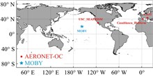
Marine remote sensing satellites, due to their specificity, heavily rely on in-situ marine observation data for the calibration of sensors and the validation of remote sensing products. The complexity of ocean remote sensing detection signals has prompted new demands for ocean observation technology. Under the impetus of spaceborne remote sensing mission requirements, countries have initiated the construction of marine calibration and validation fields. This paper investigates the current situation and development trends of global marine calibration and validation field networks, starting from the observation technology systems of global marine calibration and validation fields and the main tasks of field sites. It showcases the achievements of Chinas marine calibration and validation field network construction, combining the practices and applications of such networks in China. The current maritime calibration field network in China has initially achieved a reasonable spatial layout and reliable data observation capabilities. With the implementation of future development plans, the construction of Chinas calibration field network is expected to provide long-term series of spatiotemporal cube datasets for field observations.
Apr. 29, 2025Vol. 46 Issue 2 1 (2025)
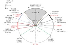
Ocean surface sunglint reflection serves as both unique information source and persistent data correction challenge in marine optical remote sensing. This study elucidates the multi-scale image characteristics and differentiation of sunglint reflections in remote sensing imagery. In coarse-resolution images, sunglint reflections exhibit statistical distribution characteristics. But high-resolution imagery reveals distinct discrete features, statistical features, and Fresnel reflection discrepancies. Current sunglint correction methods for marine optical imagery are systematically summarized and applied to multi-source remote sensing datasets. The application characteristics of different correction approaches are analyzed to discuss the effectiveness of sunglint reflection variations in detecting ocean surface targets, marine environmental dynamics phenomena, and environmental monitoring. Finally, prospects for future advancements in ocean sunglint remote sensing are outlined, providing a foundation for subsequent research endeavors.
Apr. 29, 2025Vol. 46 Issue 2 133 (2025)
Practice and Application of Integrated Satellite-Earth Calibration for China’s Ocean Color Satellite
Shuguo CHEN, Zhaowei LIU, Sicong LI, Chaofei MA, Junwei WANG, Shixian HU, Qingjun SONG, Hailong PENG, Jilei JING, and Pengmei XU
The integrated satellite-earth calibration performs preliminary calibration of ocean color satellite sensors through onboard solar calibration, and further reduces the uncertainty in the solar calibration and atmospheric correction processes by using system vicarious calibration. This article provides a detailed introduction to the methods and processes of integrated satellite-earth calibration, key issues identified and targeted solutions. It covers aspects such as the periodic influence of the solar beta angle during calibration and the correction of the anisotropic degradation of the solar diffuser. Through practical application on China's ocean color satellites, the accuracy of integrated satellite-earth calibration and the consistency of data products have been analyzed and validated. The results show that the integrated satellite-earth calibration accuracy of China’s ocean color satellite meets research requirements, and the data products exhibit high consistency with international mainstream satellites. Through high-precision integrated satellite-earth calibration, the China’s ocean color satellite can provide accurate observational information for ocean monitoring and environmental protection, and provide a solid foundation for independently generating climate data records.
Apr. 29, 2025Vol. 46 Issue 2 96 (2025)
Yuehai XU, Lei GUAN, Liqin QU, Yan LI, Ting YANG, and Rui CHEN
The 2nd Chinese Ocean Color and Temperature Scanner (COCTS2) is a key payload onboard the new-generation ocean color observation satellite Haiyang-1E (HY-1E). COCTS2 has three thermal emissive bands (TEBs). To ensure the stability and accuracy of the TEB, COCTS2 is equipped with onboard high-temperature and low-temperature blackbodies combined with the view of deep space to calibrate TEBs on-orbit. The COCTS2 on-orbit calibration method with the use of the Infrared Atmosphere Sounding Interferometer (IASI) data to correct the angular variation of reflectance of half angle mirror is presented in this paper. Secondly, the on-orbit stability of COCTS2 is evaluated. The results show that the bias of B16 compared with IASI is 0.14 K, with a standard deviation of 0.33 K. The bias of B17 and B18 with IASI is less than 0.1 K, with standard deviation of about 0.5 K. The Noise Equivalent Difference Temperature (NEDT) is less than 0.1 K for three bands. The temperature of two blackbodies, the digital number of the detector, and the NEDT remain stable.
Apr. 29, 2025Vol. 46 Issue 2 111 (2025)
Yan LI, Haiyan WANG, and Hongyan HE
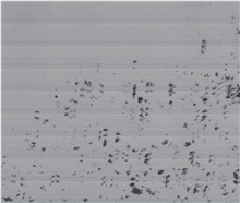
The non-uniformity correction is crucial for the successful application of infrared images, as it directly impacts the visual quality and the accuracy of sea surface temperature. However, this method often results in residual stripe noise and flash pixels within the infrared remote images, which fails to meet the requirements for high-sensitivity infrared images. To improve the relative radiation correction precision for high-sensitivity infrared images, we propose a high-precision non-uniformity correction algorithm in this paper. Firstly, infrared marine images are corrected based on on-board calibration data. Secondly, an improved statistical algorithm based on small samples of infrared images is proposed to remove residual stripe noise. Finally, flash pixels are detected and removed based on the images in real-time. The accuracy of the relative radiation correction was better than 1%, and the algorithm's validity was verified through experiments.
Apr. 29, 2025Vol. 46 Issue 2 122 (2025)
Li SHENG, Peize LI, Yangrui XU, Junnan BIAN, and Kun LIANG
Bathymetry is very important for the study of marine environment. The traditional laser echo algorithm can process the echo signal quickly and realize the water depth measurement. However, due to the influence of water turbidity and water depth, the laser echo signal obtained in some areas will appear weak water bottom echo signal or overlap of water surface and bottom echo, which brings challenges to the extraction of water depth information. In order to solve these problems, a Deep Learning model CNN-LSTM is proposed in this paper. Firstly, each bin value of laser echo are taken as data point, then these data points are classified into water surface points, water bottom points and noise points by deep learning method. The water depth information of the laser echo signal is calculated according to the coordinates of water surface points and water bottom points. Data points classification and bathymetric experiments are carried out with laser echo data from the South China Sea, the experimental results show that the classification accuracy of this model reaches 97.62%. At the same time, the water depth information of the laser echo signal is calculated and compared with the in-situ data. The RMSE reaches 0.46 m which is better than the single CNN、LSTM and 1D FCN models. This paper provides a good idea and scheme for the field of laser echo sounding.
Apr. 29, 2025Vol. 46 Issue 2 146 (2025)
Jiangwei CHEN, and Xiaoliang MENG
In recent years, significant progress in deep learning and computer vision has promoted the development of remote sensing change detection. However, the existing methods still rely on a single visual modality and cannot effectively utilize information from other modalities, such as structure priors such as elevation maps or depth maps. In order to make full use of structure prior information such as depth maps, this paper propose a novel very-high-resolution remote sensing change detection framework SPP-CD with structure prior perception ability. The framework accepts bi-temporal optical remote sensing images and corresponding depth maps as input, uses a siamese encoder structure to extract features from the input data, and then uses a feature interaction module to interact and fuse the bitemporal features. Finally, a feature decoder is used to decode the fused features and output a fine-grained pixel-level change detection map. A dual path fusion multimodal feature encoder is designed based on the SPP-CD framework, which utilizes a global path based on cross modal attention and a local path based on convolution to enable the model to combine long-distance context modeling, cross modal feature modeling, and fine feature extraction capabilities. Experimental results on the LEVIR-CD dataset show that compared with the existing single modal baseline methods, the method proposed by this paper achieved 92.36%, 85.81% and 99.21% on the key indicators F1, IoU and OA respectively, surpassing the single-modal baselines, thus proving that integrating spatial structure prior information can effectively improve the change detection performance and alleviate the limitations of existing methods that mainly rely on visual information.
Apr. 29, 2025Vol. 46 Issue 2 157 (2025)
Xiaomin YE, Zhijia LIN, Heli TENG, Maohua GUO, and Xiaomei WANG
In recent years, the green tide of Enteromorpha prolifera has become a marine ecological disaster in the Yellow Sea. Meanwhile, as a technology, the satellite remote sensing provides effective basic monitoring information for the prevention and control of the marine ecological disaster. The China's Ocean Color Satellites (HY-1C, HY-1D and the new-generation ocean color observation satellite) can provide multi-resolution synchronous observation data for monitoring the large floating Enteromorpha prolifera. In this study, the analysis method of quasi-true color synthesis for image and the Normalized Difference Vegetation Index (NDVI) are used to analyze the remote sensing characteristics of floating Enteromorpha prolifera on the sea surface from the image, spectrum, spatial-temporal coverage and the difference of the extracted information by using the multi-resolution remote sensing monitoring data. The analysis results indicate: spatial resolution is the key influencing factor for remote sensing monitoring of floating seaweed on the sea surface; China's ocean color satellite remote sensing images with spatial resolution of higher than 500 m can be well used for monitoring the floating Enteromorpha prolifera in its outbreak period; China's ocean color satellites can cover the floating Enteromorpha prolifera monitoring area in the Yellow Sea once a day with the medium resolution; NDVI increases with the enlargement of the seaweed's coverage; the distribution of Enteromorpha prolifera directly observed from remote sensing images with different resolutions has significant differences, and there is a negative correlation between their resolution and the monitored distribution area. The results of the paper have significance in ecological monitoring applications by using China's ocean color satellite data and demonstrating the specifications for coming satellite.
Apr. 29, 2025Vol. 46 Issue 2 13 (2025)
Keli ZHANG, LIli WANG, and Cheng YAN
The new-generation ocean color observation satellite is a key marine remote sensing research satellite under China's 13th Five-Year Plan. It carries three payloads: an ocean color and temperature scanner, a programable medium resolution imaging spectrometer, and a coastal zone imager. The satellite platform integrates 46 remote sensing spectral bands for ocean color and temperature detection, covering ultraviolet, visible, near-infrared, short-wave infrared, and mid-/long-wave infrared wavelengths. It achieves multiple spatial resolutions (5 m, 20 m, 100 m, and 500 m) and demonstrates improvements in radiation quality, system accuracy, operational efficiency, and service lifespan. These capabilities meet the requirements for multi-element, multi-scale, and multi-task ocean observation, with performance reaching or approaching that of international counterparts in ocean color remote sensing. This article introduces the technical features, development risk control, and on-orbit testing of the new-generation ocean color observation satellite, providing a comprehensive summary of its innovations.
Apr. 29, 2025Vol. 46 Issue 2 27 (2025)
Xiaohong ZHANG, Bei CHU, Jun ZHENG, Tuotuo LI, Yang GAO, Xiaolin LIU, Ke LI, Jiankai FAN, Wei CAO, Muqing WANG, Hui LIU, Lei WANG, Wenwen QI, Pengmei XU, and Keli ZHANG
To meet the user requirements for high resolution, high signal-to-noise ratio, wide dynamic range, and high revisit frequency in coastal zone observation, the coastal zone imager on the next-generation ocean color observation satellite employs an off-axis three-mirror main optical system and multi-spectral integrated high-sensitivity TDICCD detectors. This setup achieves high signal-to-noise ratio and wide dynamic range imaging across nine spectral bands under low water body radiance conditions, with a panchromatic spectral resolution of 5 meters and a multi-spectral resolution of 20 meters. The design of a large aperture pointing swing mirror, in combination with long-life mechanism design and high-precision closed-loop control, ensures the realization of high precision and reliability and the flexibility and maneuverability in orbit for the imager. The swath width, without the satellite side-to-side motion, reaches 1029 kilometers. Through ground testing and in-orbit operation verification, all performance indicators of the imager meet the design requirements and user needs. It has significant application prospects in enhancing coastal zone remote sensing observation capabilities, serving marine resource development and environmental protection.
Apr. 29, 2025Vol. 46 Issue 2 40 (2025)
Ting YANG, Pengmei XU, Zhihong FU, Pengfei DUAN, Sheng LI, Bin HU, Jingyi WANG, and Keli ZHANG
The ocean color and temperature remote sensor is an important tool for monitoring the marine ecological environment, assessing primary productivity of the ocean, and studying global sea surface temperature changes. New generation ocean color and temperature scanner addresses the shortcomings of traditional ocean color remote sensors in terms of spatial resolution, spectral range setting, signal-to-noise ratio, and calibration accuracy. For the first time in China, a system design scheme for telescope overall rotation scanning and half angle mirror synchronous tracking is proposed. Firstly, an innovative rotating off-axis three mirror optical system was designed, combined with scanning imaging mode and a large pixel detector design, achieving system sweep width ≥3000 km, signal-to-noise ratio ≥1000, noise equivalent temperature difference of infrared band ≤0.1 K, system polarization sensitivity ≤1.5%, and stray light coefficient ≤1%. Secondly, in response to the demand for multi band and high-precision calibration on board, a full aperture and full path onboard calibration technology based on a rotating telescope has been proposed, which improves the solar calibration accuracy of the payload to within 2%. The performance test results indicate that the system surpasses comparable load-bearing systems both domestically and internationally in multiple metrics, the research results can provide technical support for the new generation of ocean color and temperature scanner in China.
Apr. 29, 2025Vol. 46 Issue 2 49 (2025)
Wei CAO, Zhengyang YU, Yingbao LI, Lingyue LI, Min WAN, and Ting YANG
To address the problem that the signal-to-noise ratio and stage linearity of the imaging circuit system under the horizontal uniform subdivision and summation timing do not meet the requirements of the camera specifications, based on the analysis of the characteristics and working principle of the ultra-large pixel TDICCD, this article proposes a design scheme for the horizontal non-uniform subdivision and summation timing. This scheme conducts timing optimization and software design from three aspects: extending the reset reference holding time of the analog signal, reducing the collection time of the intermediate charge packet, and extending the collection time of the last charge packet. As a result, the pre-sampling and post-sampling regions of the correlated double sampling are increased by more than 3 times and 1.7 times respectively, improving the sampling reliability. Moreover, the hardware design and performance test verification of the imaging circuit system are completed. The laboratory test results show that the signal-to-noise ratio in all spectral bands of the ultra-large pixel TDICCD is greater than 67 dB, and the stage linearity is better than 99%, meeting the requirements of the camera specifications. Meanwhile, the texture of the on-orbit images is clear, and the spectral bands have distinct layers, further verifying the application of this scheme.
Apr. 29, 2025Vol. 46 Issue 2 63 (2025)
Jun ZHENG, Xiaomin ZHANG, Huan LIU, Chao WANG, Yuze CAO, Bei CHU, Yiqiu ZHANG, Yuyao WANG, and Xiaohong ZHANG
To meet the demand of high-precision directional and detailed detection in a wide coastal zone, the new generation of ocean color observation satellites, the Coastal Zone Imager, employs the imaging technology featuring a front-mounted wide-range pointing mechanism. It utilizes a drive system consisting of "stepper motor rotation + harmonic gear reducer transmission" and a telemetry system incorporating "Hall effect digital switch circuit + absolute photoelectric encoder". Through successive approximation closed-loop control, it achieves a detection range of 1,000 km with an accuracy better than half a step angle, enabling accurate on-orbit line-of-sight positioning and precise surveying of hotspot areas. In ground laboratory tests, the Coastal Zone Imager achieved a control accuracy of better than 20 arcseconds and a measurement accuracy of better than 10 arcseconds for the line-of-sight pointing angle. The on-orbit tests fully verified the feasibility and robustness of this line-of-sight pointing system. This design is characterized by high positioning accuracy, high reliability, good safety, and compact scale, and is of great significance for directional and detailed detection in wide coastal zones.
Apr. 29, 2025Vol. 46 Issue 2 72 (2025)
Zhicheng SHI, Shoucai ZHANG, Dongnan CHI, Jing DING, Xianqiang HE, and Pengmei XU
The geostationary satellite has the characteristics of "standing high, seeing wide and staring long", and has the capability of large width imaging, continuous staring imaging and high timeliness imaging, which can realize the rapid response to various emergency observation tasks. The developments of high-orbit ocean remote sensing satellites and the array-gazing optical remote sensing system in ocean and coastal zones observation can fill the gap of dynamic monitoring on the marine environment in high orbit in China, and meet the urgent demand for observation and emergency monitoring of the surrounding sea areas, nearshore and islands of China. By analyzing the technical characteristics of the high-orbit optical remote sensing system for the ocean and coastal zone, a system design scheme has been put forward, in which many technologies are adopted, such as a large-aperture optical system with low stray light, low polarization and multi-spectral features, a high improvement in the signal-to-noise ratio, and an on-board calibration with high precision. Based on this, the prototype development and system testing have been completed, and combined with field tests, the feasibility of the core indicators has been effectively verified, laying a technical foundation for the implementation of the high-orbit optical remote sensing system project for the ocean and coastal zone.
Apr. 29, 2025Vol. 46 Issue 2 86 (2025)
© Copyright 2018-2021 | Chinese Laser Press.
All Rights Reserved 沪ICP备15018463号-20