


Please enter the answer below before you can view the full text.

2025
Volume: 46 Issue 4
14 Article(s)
Chunmei WANG, Jian YANG, Tao YU, Qiyue LIU, Lili ZHANG, Longfei LIU, Xinxin QIU, and Huizi YANG
Under the background of high-quality development of China's satellite remote sensing technology, the multi-source satellite soil moisture products in the "standarization for satellites design and it's optimal applications" space engineering application face challenges such as inconsistent product specifications and limited collaborative application due to algorithm differences, sensor performance, and surface complexity. To address this core issue, this article takes the construction of a standardized and strictly quality-controlled soil moisture standard quantitative product (SSMP) as the core goal. It breaks through the traditional single-satellite verification mode and innovatively builds a standardized, multi-level soil moisture control system. It also proposes a large-scale accuracy verification process for SSMP based on the control system. This system provides an expandable standardized production framework and a systematic quality inspection path for multi-source satellite soil moisture products. It not only lays a methodological foundation for the subsequent large-scale collaborative application and integrated analysis of remote sensing soil moisture products, but also offers important theoretical support and practical reference for further enhancing the engineering application efficiency of multi-source satellite remote sensing data in fields such as agriculture, hydrology, and meteorology.
Aug. 30, 2025Vol. 46 Issue 4 128 (2025)
Xueke CHEN, Xiaofei MI, Jian YANG, Tao YU, Miao LIU, Qiyue LIU, Zhenzhao JIANG, and Zhanliang YUAN
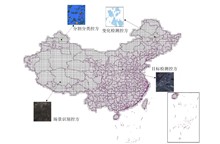
Land cover products are the main products among remote sensing satellite products, presenting the state and changes of the earth's surface and serving global environment and regional sustainable development. However, affected by factors such as different image data sources, classification techniques and production environments, the product accuracy shows great differences in practical applications, which are reflected in product varieties, specifications, quality, scale and timeliness, resulting in huge challenges in the authenticity verification of land cover products in practical applications. In this paper, aiming at the aerospace remote sensing application mode of "standarization for satellites design and it's optimal applications", a land cover product verification method based on ground control DS of classification is proposed. Starting from the requirements for verification samples in terms of quantity, quality, and distribution, it constructs credible classified control parties with controllable distribution, quantity, and quality, optimizes the verification process, and realizes truth-value verification for land cover products produced from different satellite data. By optimizing the verification process, a new approach is provided for the authenticity verification of large-scale land cover products.
Aug. 30, 2025Vol. 46 Issue 4 139 (2025)
Qi WANG, Le SUO, Jian YANG, Xiangzhi HUANG, and Chuan LIU
As a pivotal pillar of China's aerospace industry, aerospace remote sensing technology exerts a profound and far-reaching influence on the development level and overall competitiveness of China's aerospace sector. Guided by the requirements for building a strong aerospace nation, this paper focuses on advancing the high-quality development of China's aerospace remote sensing. It systematically reviews the current development status, major achievements, and challenges confronted by China's aerospace remote sensing, conducts an in-depth analysis of the development models and characteristics of international aerospace remote sensing, and on this basis, explores new ideas and models for the construction of China's satellite remote sensing system, with a view to providing references for promoting the high-quality development of China's aerospace remote sensing.
Aug. 30, 2025Vol. 46 Issue 4 1 (2025)
Tao YU, Pan XIONG, Xingfa GU, Chuan LIU, Jun GAO, Yu WU, Gengke WANG, Yameng ZHAO, Jian YANG, and Yulin ZHAN
Modeling approach is one of the key means of expressing and understanding of remote sensing activities. The remote sensing activity model set discussed herein is with the recognition of the interplay among remote sensing systems, observation targets, and individuals. It is formulated through several layers, of simplification and standardization, across dimensions including information, data, hardware and software, as well as evaluation. The systems engineering approach, derived from the integration of this suite of remote sensing activity models, robustly applied in several projects demonstration, exploring the role of remote sensing systems in practical construction and application, continuously enhancing their maturity, and providing strong support for establishing a system characterized by "Chinese standards, Chinese data, Chinese technology, and Chinese applications" featuring independent innovation.
Aug. 30, 2025Vol. 46 Issue 4 9 (2025)
Yu WU, Tao YU, Yulin ZHAN, Lijuan ZHENG, Gengke WANG, Donghai XIE, Xiaofei MI, Lili ZHANG, Chunmei WANG, Chuan LIU, Wenqian ZANG, Xiangzhi HUANG, Yanming GUO, Baoyu WANG, and Juan LI
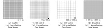
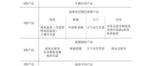
Recently, quantitative products of space-borne remote sensing have gradually become important inputs for various applications in China, widely serving fields such as meteorology, oceanography, natural resources, ecological environment, and Earth system research. Although the rapid growth in the number of remote sensing satellites, the widespread use of remote sensing data is severely restricted due to their differences in data formats, processing methods, and application fields of different satellite systems. To reduce the threshold for using remote sensing data, we proposed a standardized data product model based on Data Square (DS) according to the remote sensing information model and data engineering model. The multi-source spatio-temporal data are normalized and organized under a unified geographic grid framework from the perspectives of data product levels, observation methods, and product attributes. Four types of control samples, namely geometric, radiometric, classification, and parametric, are applied for the relative truth constraints of data squares. Synthetic product production is carried out for data square collections acquired by different constellations, satellites, and remote sensors at different times and locations, forming spatio-temporally consistent remote sensing standard quantitative products and file codes. The advantages and disadvantages of the proposed models are further investigated for the existing Analysis Ready Data (ARD) models in the space-borne remote sensing, providing technical support for the vision of universal application across multiple satellites.
Aug. 30, 2025Vol. 46 Issue 4 27 (2025)
An Assessment Method of Hydrological Drought Based on Optical Remote Sensing Land Surface Water Area
Fei HUANG, Xiao GUAN, Qingfeng RUAN, Jia TIAN, and Qingjiu TIAN
Drought is increasingly becoming a critical global issue, and satellite optical remote sensing provides an essential tool for large-scale drought monitoring and assessment. This study focuses on Lushan City in Jiangxi Province and proposes a method for assessing hydrological drought by monitoring water surface area using multispectral remote sensing. Sentinel-2 MSI data is used to extract water surface areas, and an empirical model calculates Poyang Lake’s water levels at different stages of drought. GF-1 WFV data is then analyzed to explore the relationship between Lushan City’s water surface area and Poyang Lake’s water levels to evaluate regional hydrological drought conditions. The results show that there is a significant correlation between the two, indicating that remote sensing technology is highly accurate and feasible for monitoring hydrological drought. The proposed method offers a new approach for dynamic drought monitoring and evaluation, providing data support for disaster prevention, mitigation, and water resource management.
Aug. 30, 2025Vol. 46 Issue 4 38 (2025)
Xiangzhi HUANG, Wenqian ZANG, Yameng ZHAO, Baoyu WANG, Gengke WANG, Dong WANG, Tao YU, and Yu WU
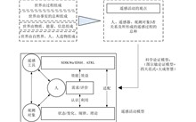
With the development of remote sensing technology, remote sensing has been widely applied in various fields and has become one of the important high-tech means to serve modern production and life of humanity. There is an urgent demand for ubiquitous remote sensing services that cater to the needs of hundreds of stars and hundreds of uses. However, due to the heterogeneity of remote sensing data, complexity of remote sensing technology, and diversity of application scenarios, remote sensing service technology for ubiquitous application scenarios is not yet mature. Among them, the standardization technology and application of remote sensing products have become a hot research topic. This article proposes a remote sensing information container information model, SPID system architecture model, and COGON network architecture model based on standard quantitative products. It proposes a remote sensing data application mode of "scalding, hot, warm, cool and icy" and conducts research on the design of multi-source heterogeneous remote sensing service mode for ubiquitous application scenarios, helping remote sensing applications shift from traditional professional data services to ubiquitous application services.
Aug. 30, 2025Vol. 46 Issue 4 153 (2025)
Jian YANG, Xiaofei MI, Zhiqiang SHEN, Zhenzhao JIANG, Xiangzhi HUANG, Yu WU, Gengke WANG, Tao YU, and Fangrong GUO
A persistent mismatch between remote sensing image acquisition and information processing capabilities poses a critical challenge for emergency monitoring. To address this issue, this study proposes an integrated framework that matches the observation requirements of different disaster types across three dimensions—scale, information, and time. Based on this framework, we design a standardized solution for remote sensing data organization, processing, and application, enabling precise grid-based localization and collective interpretation in emergency-affected areas. Validation experiments conducted on a prototype ground-based information integration and response platform, built for emergency observation with domestic satellites, demonstrate significant improvements in efficiency: the volume of processed data was reduced by approximately 99.7%, data transmission time was shortened from minutes to seconds, and regional target extraction was achieved within a minute-scale timeframe. These results confirm that the proposed solution markedly accelerates the transmission and processing of emergency remote sensing data, providing strong support for the rapid localization and extraction of emergency targets.
Aug. 30, 2025Vol. 46 Issue 4 164 (2025)
Junsong LENG, Zhong CHEN, Aiguo TIAN, Chang TIAN, Tao YU, Jian YANG, Xiaofei MI, and Xian SUN
Remote sensing, especially high-resolution remote sensing, has been increasingly applied in emergency management due to its advantages, including instantaneous imaging, wide coverage, dynamic updates, minimal constraints from ground conditions, long-term monitoring capabilities, and comprehensive information acquisition. It makes its application in emergency management highly significant. Based on the typical real-world case of the MH370 remote sensing image search and rescue, this study addresses challenges such as the vast search area, severe background interference, diverse target information, and weak feature representation. By leveraging an application-oriented spaceborne remote sensing sample database, we propose an adaptive Gaussian kernel support vector machine (SVM) search technique for typical maritime accident targets that integrates multiple features. This method first extracts multiple features to form feature vectors and dynamically adjusts the kernel parameters of each sample point based on local data density. It enables automatic adaptation, thereby improving classification accuracy and model generalization while addressing the overfitting and underfitting issues caused by fixed kernel parameters in traditional SVMs. Additionally, the study employs multispectral cosine similarity to further assess the resemblance between floating objects and other targets on the sea surface, verifying the reliability of suspected areas where the missing aircraft might have been located.
Aug. 30, 2025Vol. 46 Issue 4 48 (2025)
Junqi ZHAO, Xiaofei MI, Jian YANG, Tao YU, Xiaomin TIAN, Chuanzhao TIAN, Hongbo ZHU, and Chuan LIU
With the rapid development of artificial intelligence technologies such as deep learning and machine learning, a large number of datasets have been generated in the field of remote sensing to meet the diverse needs of remote sensing tasks. However, these datasets exhibit significant differences in type, size, spatial and temporal resolution. To address this issue, this paper proposes a standardized multimodal sample dataset organization method oriented towards artificial intelligence interpretation. This establishes an effective link between samples and image data, forming a temporal sample dataset based on geographical spatial locations. This meets the demands of intelligent interpretation for a data cube that is scalable in terms of big data, multimodality, and samples. It achieves orderly management of massive remote sensing sample data while also supporting continuous expansion and reuse of samples. This paper applies the multimodal sample dataset organization method from both dataset and systematic management, providing effective data and technical support for artificial intelligence interpretation in various remote sensing tasks.
Aug. 30, 2025Vol. 46 Issue 4 59 (2025)
Tianyu ZHAO, and Jia TIAN
The physiological and biochemical parameters of forest vegetation change over time, leading to alterations in their spectral characteristics and resulting in the phenomenon of "spectral variability of the same object". To analyze the temporal spectral variation patterns of forest vegetation, this study simulates the temporal spectra of canopy of typical tree species during typical phenological periods of the year based on the PROSAIL model. The Height of a Single Triangle (HST) is constructed, and the Heights of Double Triangles (HDT) is proposed. They are applied to Sentinel-2 A/B multispectral remote sensing images and the causes of temporal spectral differences are explored. Taking Langya Mountain and Laojiashan in Anhui Province, as well as Tieshansi Forest Farm in Jiangsu Province as examples, the study analyzes and extracts the temporal spectral variation patterns and characteristics of forest vegetation. The research results indicate that the HST index can represent the temporal variation characteristics of forest vegetation: it increases rapidly from the bud burst stage (March) to the leaf expansion stage (May) and decreases slowly from the peak stage (June) to the browning stage (November). The HDT feature space can represent the distribution pattern of forest vegetation samples forming an obtuse-angled triangle shape over time, providing a new methodological and technical approach for extracting the temporal spectral variation patterns of forest vegetation.
Aug. 30, 2025Vol. 46 Issue 4 73 (2025)
Tairu CHEN, Lili ZHANG, Tao YU, Dong YAO, and Wen DONG
By generating high-resolution remote sensing images, Spatio-temporal fusion technology provides an efficient and low-cost solution for continuously monitoring dynamic changes in the Earth. With the continuous development of spatiotemporal fusion technology, various methods have been proposed in recent years, yet accurately simulating and predicting spatial details and textures in complex land areas remains challenging. This paper introduces ACLSDF, a spatio-temporal data fusion method suitable for complex land. ACLSDF computes temporal and spatial changes through linear regression and guided filter, respectively, and assigns different spatio-temporal weights to pixels undergoing changes in land cover type using a change index. It then combines these changes with the change index to calculate the final predicted values. In order to evaluate the performance of the ACLSDF method in heterogeneous areas, this paper conducts a comparative analysis experiment between the ACLSDF fusion results and ground-measured spectral data. Results show that ACLSDF achieves a correlation coefficient above 0.93, a root mean square error below 0.07, and structural similarity indices over 0.98 in complex surface areas. The root mean square error compared to in-situ measured spectral data is less than 0.04, second only to the original GF-1 WFV images, confirming the feasibility and efficacy of the proposed method.
Aug. 30, 2025Vol. 46 Issue 4 88 (2025)
Yutang YU, Tao YU, Donghai XIE, Yu WU, Lili ZHANG, and Xin ZUO
The radiative transfer coupling between the Earth's surface and the atmosphere is highly complex, resulting in limitations in the accuracy and efficiency of traditional atmospheric correction techniques. Empirical linear methods offer relatively high computational efficiency but suffer from low precision, while radiative transfer model-based approaches achieve higher accuracy at the cost of substantial computation, restricting the quantitative application of multi-spectral satellite remote sensing. With the development of neural networks, integrating physical models with data-driven approaches has provided new vision for atmospheric correction. This study proposes a deep neural network framework trained on datasets simulated by radiative transfer models, which not only ensures correction accuracy but also significantly improves processing efficiency. First, radiative transfer model is used to simulate satellite top-of-atmosphere radiance under different observation geometries and atmospheric–surface conditions, thereby constructing a forward-simulated multi-spectral remote sensing dataset for data-driven atmospheric correction. The neural network then learns the geographic, geometric, and spectral characteristics embedded in the dataset to achieve pixel-level atmospheric correction. The study demonstrate that the proposed method achieves an average absolute error of 0.028 and a relative error of 0.82 compared to pixel-wise correction using radiative transfer models, while improving processing speed by approximately six orders of magnitude. Compared with mainstream physical-model-based methods in terms of image quality, quantitative metrics, and consistency with in-situ measured vegetation spectra, the proposed method performs favorably. This research provides an efficient atmospheric correction pathway for the quantitative application of multi-spectral remote sensing imagery.
Aug. 30, 2025Vol. 46 Issue 4 101 (2025)
Miao LIU, Xuechun ZHAO, Xingfa GU, Yulin ZHAN, Tao YU, Juan LI, Linghan GAO, Shiyuan ZHANG, and Zhangjie WANG
To systematically investigate the influence of atmospheric correction on Fractional Vegetation Cover (FVC) retrieval accuracy, this study utilizes two test scenes of GF-1 satellite imagery with mountain coverage ratios of 18.3% (low-mountain scenario) and 99.3% (high-mountain scenario) respectively. FVC is retrieved using apparent reflectance (without atmospheric correction) and surface reflectance (with atmospheric correction) respectively to quantitatively evaluate differential impacts of atmospheric correction across varying mountainous terrains. Comparative experiments reveal that: in low-mountain scenario, FVC retrieval using apparent reflectance remained acceptable, while atmospheric correction improves accuracy by 0.93%. In high-mountain scenario, overall FVC retrieval accuracy declines significantly, with coefficient of determination decreasing over 10% and Root Mean Square Error increasing beyond 50% for both corrected/uncorrected data, though atmospheric correction still provided 2.7% accuracy improvement. The results quantitatively demonstrate that atmospheric correction consistently enhances FVC retrieval precision, particularly proving essential for high-mountain areas to ensure reliability. These findings provide empirical evidence for prioritizing atmospheric correction in mountainous remote sensing applications.
Aug. 30, 2025Vol. 46 Issue 4 116 (2025)
© Copyright 2018-2021 | Chinese Laser Press.
All Rights Reserved 沪ICP备15018463号-20