


Please enter the answer below before you can view the full text.

Journal of Atmospheric and Environmental Optics
Co-Editors-in-Chief
Wenqing Liu

2025
Volume: 20 Issue 4
11 Article(s)
GUO Mengxing, WU Pengfei, FAN Zizhao, and RAO Ruizhong
Modulation transfer function (MTF) is an important indicator to evaluate the effect of turbid atmosphere on the imaging quality of objects. Based on the equivalence principle, this paper studies the quantitative relationship between MTF and key atmospheric optical parameters by using the discrete coordinate numerical solution method of radiative transfer and the linear fitting method, and establish the parametric analytical MTF model in turbid atmosphere. The results have revealed that in the range of optical thickness 0.1–1.0, single scattering albedo 0.1–1.0, and asymmetry factor 0.05–0.95: 1) As for the factors affecting the critical frequency, optical thickness is the largest, followed by scattering albedo, and asymmetry factor is the smallest. 2) In termes of factors affecting MTF, in the low spatial frequency range, the optical thickness is the largest, followed by the single scattering albedo, and the asymmetry factor is the smallest; while in the high spatial frequency range, the single scattering albedo is the largest, followed by the optical thickness, and the asymmetry factor is the smallest. 3) The overall average relative error of the established model is less than 8%, and for many practical application scenarios (asymmetric factor ≥ 0.7, single scattering albedo ≥ 0.55), the average relative error of the model is less than 5%.
Jul. 28, 2025Vol. 20 Issue 4 423 (2025)
WANG Siyuan, NI Changjian, MENG Zisheng, SHI Qiaoyu, JIANG Mengjiao, and ZHANG Ying
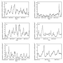
The occurrence of haze events is the consequence of complex interactions between aerosols and specific multi-scale processes, including atmospheric boundary layer variations, weather and climate processes, and atmospheric chemical processes. Utilizing the hourly observation data of PM2.5, surface visibility and relative humidity in Chengdu, China, from 2014 to 2017, the atmospheric extinction coefficient time series of six haze events during the observation period were retrieved firstly by Koschmieder's formula. Then based on the phase space reconstruction theory, the optimal delay time τ and the optimal embedding dimension m of the corresponding series were calculated, and the recurrence plot method was used to verify that the atmospheric extinction coefficient time series of the haze events originated from the evolution of the deterministic systems. Finally, the time series nonlinearity of atmospheric extinction coefficient in haze events was tested. The analysis of nonlinear characteristic variables (saturation correlation dimension, maximum Lyapunov exponent and Kolmogorov entropy) showed that the time series of atmospheric extinction coefficient had weak chaotic characteristics, the application of Cao method excluded the possibility that the time series was random, and the further diagnosis of surrogate data method finally determined that the extinction coefficient time series of the haze events were nonlinear. Our findings reveal the complexity of the atmosphere extinction coefficient time series of the haze events and lay the foundation for a deeper understanding of the evolutionary behavior of haze systems.
Jul. 28, 2025Vol. 20 Issue 4 436 (2025)
YANG Huan, XIE Pinhua, HU Renzhi, LIN Chuan, TONG Jinzhao, CHEN Liang, and WANG Ruishuo
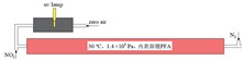
Dinitrogen pentoxide (N2O5) is the most important active nitrogen species at night, and accurate detection of it is important for understanding chemical processes in the atmosphere at night. The high precision cavity based cavity ring down spectroscopy (CRDS) and cavity-enhanced absorption spectroscopy (CEAS) have become the most popular methods for N2O5 detection due to their high sensitivity and fast response time. However, N2O5 has the characteristics of high activity and easy loss, which affects the measurement accuracy of it. In order to ensure the accuracy of N2O5 measurement in the field by the N2O5-CRDS detection system, a set of device for on-line stable synthesis of N2O5 standard source was developed in this work, which can generate stable concentration of N2O5 by controlling the reaction of O3 and NO2, and then, the transmission efficiency of N2O5 gas in the N2O5-CRDS detection system was further studied. The transmission efficiency of N2O5 in perfluoroalkoxy alkane (PFA) sampling tube (length 3 m, outer diameter 6.35 mm) , Teflon film holder (filter with 5 μm PTFE) and heated PFA tube (outer diameter 12.7 mm) were investigated, and finally the total transmission efficiency of N2O5 was obtained as 86.74% based on the system parameters used infield observation. The comparison results show that the transmission efficiency measured by this method is in good agreement with the calibration results of other works, which verifies the validity of this method.
Jul. 28, 2025Vol. 20 Issue 4 449 (2025)
ZHOU Yu, WANG Li, and ZHA Shenlong
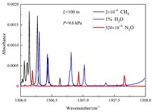
The greenhouse effect has a great impact on the earth's environment and climate, so accurate detection of greenhouse gases is of great significance. As one of the important greenhouse gases, nitrous oxide (N2O) has a much higher greenhouse effect potential than carbon dioxide (CO2). However, compared to the widely studied CO2 and methane (CH4), there is less research on N2O. In this paper, a system based on a domestically developed 7.6 μm mid infrared quantum cascade laser was established for atmospheric N2O detection. The system adopts wavelength modulation and the second harmonic detection technology, with the N2O absorption line at 1307.66 cm-1 as the target line. Firstly, the optimal modulation amplitude of the system was determined by detecting the second harmonic signal of a certain concentration of N2O at different modulation amplitudes. Then under the optimal experimental conditions, N2O gas with different concentrations was measured, and the signal-volume fraction calibration curve of the system was obtained. The results showed that the minimum detection limit of N2O volume fraction of the system was 1.34 × 10⁻⁹, indicating that the system can meet the needs of atmospheric N2O measurement. A 6-hour detection of N2O was further carried out, and the averaged volume fraction of N2O during detection was 325 × 10-9, which is equivalent to the well-known volume fraction of atmospheric N2O of 320 × 10-9.
Jul. 28, 2025Vol. 20 Issue 4 461 (2025)
FENG Jiaxuan, LI Qihua, CHANG Bowen, and LUO Jinyi
As intermediates of atmospheric photochemical reactions, formaldehyde (HCHO) and glyoxal (CHOCHO) are often used as important tracers of atmospheric volatile organic compounds (VOCs), and monitoring and investigating their distribution and evolution plays an important role in regional air pollution monitoring. This study is based on the HCHO and CHOCHO data of the multi-axis differential optical absorption spectroscopy (MAX-DOAS) observation station in Qingyuan campus of Anhui University (117.18°E, 31.77°N), Hefei, China, from July to September in 2021. Firstly, the radiative transfer model SCIATRAN is selected as the forward model, and the vertical profiles of HCHO and CHOCHO are retrieved by the optimization estimation algorithm.Then, the distribution and evolution characteristics of HCHO and CHOCHO in this region are analyzed by comparing with the observation data of Tropospheric Monitoring Instrument (TROPOMI) carried on Sentinel-5 satellite and combining with the meteorological data. The strong correlation with TROPOMI observation data proves the high confidence level of the MAX-DOAS data. The results indicate that the HCHO profile near the ground has obvious diurnal variation, with higher levels at noon and at night. The weekly variation curve of HCHO is related to the activities of the residents, and it is shown that the HCHO concentration from Friday to Sunday is 20.13% higher than that of other working days, demonstrating an obvious weekend effect. Because CHOCHO and HCHO have different formation pathways as tracers, the ratio of CHOCHO to HCHO (RGF) is also studied to determine the emission source of VOC precursors. The analysis of RGF curve shows that biological VOC emissions are more prevalent in Hefei City. During the observation period, periods dominated by biological VOC emissions accounted for approximately 72.29% of the total observation time. This work explores the distribution and behavior evolution of HCHO and CHOCHO in Hefei, which provides a reference for the monitoring and prevention of air pollution in this area.
Jul. 28, 2025Vol. 20 Issue 4 470 (2025)
LU Dachun, ZHUANG Peng, SONG Ci, SUN Guanghe, and XIE Chenbo
Ozone lidar is an effective tool for detecting the spatial and temporal distribution of tropospheric ozone. An ozone lidar based on the differential absorption was developed in this work. The lidar emits Raman excited 289 nm and 316 nm wavelength pairs, uses a 300 mm aperture telescope to receive backscattered echo signals, and can perform ozone concentration profile detection within a height range of 300–3000 m. On the basis of comparing and calibrating the horizontal and vertical detection data with those of ozone analyzer at national control points and those of sounding balloons respectively, the ozone lidar was placed in the Beijing-Tianjin-Hebei region, China, for all-weather real-time monitoring. The observation results of two typical ozone pollution processes occurred in the region in 2022 were selected to analyze the causes of local ozone pollution and the deposition process of polluted air masses in the air. It was shown that in one of the ozone transport process, polluted air masses appeared in the atmosphere at an altitude of 900–1400 m above the ground and continued to settle, resulting in an increase in the mass concentration of ozone pollutants. And airborne polluted air masses and locally generated ozone interacted with each other, resulting in heavily polluted weather. Another long-term ozone pollution process analysis showed that, during the pollution period, the concentration of ozone near the ground varied greatly between day and night. An ozone residue layer appeared above 500 m, and high concentration of ozone in the residue layer continued to exist until the next day, then continued to overlap with locally generated pollutants, resulting in prolonged and persistent ozone pollution weather.
Jul. 28, 2025Vol. 20 Issue 4 484 (2025)
CHEN Jiawei, ZHANG Qiangling, MA Zhaoyun, ZOU Xue, HUANG Chaoqun, BO Guangyu, SHEN Chengyin, and CHU Yannan
A new drift tube structure for proton transfer reaction mass spectrometry, called conical funnel drift tube, is designed in this work, which is composed of 20 traditional ring electrodes and 5 new conical electrodes. Firstly, the ion focusing effect of the new drift tube is verified by ion trajectory simulation, and then further comparative experiments are conducted to validate the performance of the new drift tube. The results show that the new conical funnel drift tube has a softer ionization effect and higher sensitivity (4.0–6.3 times) than the traditional drift tube. Moreover, different from the traditional RF focusing method, the new conical funnel drift tube can realize ion focusing only through DC electric field without the need of additional RF power supply, making it especially suitable for instruments requiring miniaturization and low power consumption to improve detection sensitivity.
Jul. 28, 2025Vol. 20 Issue 4 496 (2025)
HE Zhibin, JIANG Yongli, WANG Pan, YANG Xiaojiao, ZHAO Rui, and HAO Yingjie
In order to investigate the mechanism of cold island effect in plateau lakes, Fuxian Lake, Xingyun Lake and Qilu Lake in Yuxi, Yunnan Province, China, were taken as research objects. Firstly, the land surface temperature inversion of the study area in 2015, 2017, 2019 and 2021 was completed based on remote sensing technology, and Geographic Information System (GIS) technology was used to classify the temperature of the lake region. Then on this basis, the temporal and spatial variation characteristics of the cooling range and cooling intensity of the lakes were analyzed, and Statistical Package for the Social Sciences (SPSS) was used to analyze the correlation between temperature and multiple landscape indices to determine the influencing factors of temperature change. Finally, ridge regression analysis was innovatively adopted to build a fitting model. The results showed that: (1) From 2015 to 2021, the areas of high temperature and sub high temperature zones increased firstly and then decreased, while the areas of low temperature and sub low temperature zones were opposite to the former, and the area of middle temperature zone continued to decrease. (2) The cooling range of Fuxian Lake was about 150–200 m beyond the water boundary, and the cooling ranges of Xingyun Lake and Qilu Lake were about 100–150 m beyond the water boundary. The average cooling intensity of Fuxian Lake, Xingyun Lake and Qilu Lake is about 7.5 ℃, 5.5 ℃ and 5.4 ℃ respectively. (3) The cold island effect of Fuxian Lake was significantly affected by water distribution, vegetation distribution and building distribution, while that of Qilu Lake was significantly affected by water distribution, vegetation distribution and distance factors, and that of Xingyun Lake is significantly affected by all factors. (4) The results of ridge regression relationship model showed that the fitting index R2 of the estimated value of the model and the inversion value are all above 0.8, indicating that the fit degree and the accuracy test results are within an acceptable range. In brief, the surface temperature in the studied lake region presented a polarizing trend of high temperature and low temperature, and vegetation, architecture, water body and distance all had influence on the cold island effect of the lakes. Moreover, the temperature fitting method based on ridge regression analysis demonstrated its practical applicability.
Jul. 28, 2025Vol. 20 Issue 4 503 (2025)
WEI Jingyi, and GAO Wei
Wetlands are the most biodiversity-rich ecosystems in nature. The commonly used models for wetland ecological security evaluation include pressure-state-response (PSR) model, improved model and mutation level model, and the evaluation results of wetland ecological security can provide quantitative support for wetland conservation policy formulation. Taking the Qilihai Wetland, Tianjin, China, as the research object, the remote sensing classification of the Sentinel-2 data in 2016, 2019 and 2022 was carried out in this work to select indicators from natural attributes and human activities, then the wetland ecological security evaluation system was constructed based on PSR model, and the ecological structure and ecological functions of the wetland were analysed. The results show that the ecological security indices of the wetland in 2016, 2019 and 2022 were 0.532, 0.553 and 0.595, respectively. From 2016 to 2022, the overall ecological security situation in the wetland showed a good development trend, and the wetland area continued to increase. Specificly, the landscape connectivity of the wetland became better, the patch density became larger, the habitat quality showed an upward trend, the area of excellent habitat quality increased by 1.53%, and the quality of wildlife habitat gradually gradually improved. The obtained results can provide a positive reference for the improvement of wetland ecological security, the sustainable development and the formulation of relevant conservation measures of wetlands.
Jul. 28, 2025Vol. 20 Issue 4 520 (2025)
LU Wenzhen, WANG Xingping, LI Xiang, ZHANG Chi, RUAN Jun, YAO lu, XU Zhengyu, CAO Nailiang, and KAN Ruifeng
Given the importance of detecting the distribution and content of water ice in the permanent shadow area of the moon, a ground simulation test platform for lunar water-ice in-situ detection is established, and then the ground whole-process simulation tests are carried out on the basis of the test platform. The ground simulation test platform includes a lunar soil preparation system, a vacuum cryogenic sample transfer and storage system, a simulation chamber, and a simulation lunar soil in-situ analysis system. The simulation test results show that under the conditions of an ambient temperature of -70 ℃ and a transfer time of 10 min, the water loss of the simulated lunar soil is less than 1.1%. In addition, the water vapor content of simulated lunar soils with three different water contents of 0.001, 0.020 and 0.050 has been measured, and the values of the water vapor pressure are 39.3, 620.1 and 1273.2 Pa, respectively. This platform can provide strong support for ground simulation, parameter calibration, in-orbit data analysis and inversion of the Chang'E-7 lunar polar region water-ice exploration mission, and will serve the subsequent lunar research stations and other major tasks.
Jul. 28, 2025Vol. 20 Issue 4 534 (2025)
BAI Xue, GUI Huaqiao, ZHAO Xin, LIU Jianguo, and ZHANG Jiaoshi
An alternative correction method for coincidence counting error in condensation particle counters (CPCs) is presented in this work. Due to the Poisson process can be used to describe the probability of particle occurrence within a certain period of time during particle counting in CPC, the per-event dead time is found to be varying with the sampling particle number concentration. Therefore, the concentration-dependent dead time can be determined experimentally and parameterized by a second-order exponential function, while parameterization also provides a good estimation of the average dead time of CPC. By using Newton's method based on concentration-dependent dead time, the particle number concentration measured by TSI 3788 water-based CPC is corrected, and an average error of less than 0.2% is achieved for particle concentrations ranging from 3000 to 40000 #/cm3. It is shown that Newton's method combined with a concentration-dependent dead time outperforms other methods with fixed dead time, including Lambert W function method and Taylor series expansion method, especially in the low particle concentration range.
Jul. 28, 2025Vol. 20 Issue 4 546 (2025)
© Copyright 2018-2021 | Chinese Laser Press.
All Rights Reserved 沪ICP备15018463号-20