


Please enter the answer below before you can view the full text.
8+2=
To ensure the validity and reliability of the secondary inversion data of environmental trace gases monitoring instrument (EMI), it is necessary to monitor the radiometric calibration accuracy and stability of the instrument in orbit for a long time. First, according to the solar spectrum and sub star radiance data measured by EMI in orbit, the surface reflectance time series of the selected data area of permanent ice and snow surface in Antarctica and Greenland are calculated, and the fourth-order bidirectional reflectance distribution function (BRDF) model between the solar zenith angle and the surface reflectance is established. Then, the surface reflectance data series from 2018 to 2020 are normalized by the fourth-order BRDF model, and the indicators representing the calibration accuracy and stability of EMI are obtained. The results show that the correlation coefficient between the predicted value of surface reflectance obtained by BRDF model and the measured value is better than 0.9. After normalizing the surface reflectance with the BRDF model, the uncertainty of radiometric calibration ranges from 2% to 5%. The total attenuation of UV2 and VIS1 channels range from -5% to 5% in two years, and that of VIS2 channel is about 1.9%, which indicates that the radiation response of EMI is stable during two years of operation in orbit.
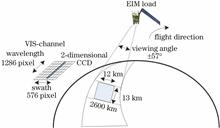
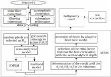
As a supplementary means of acoustic measurement, satellite depth inversion plays an important role in disputed islands and reefs. However, due to the lack of measured water depth data and the limitation of the number of visible light segments in multi-spectral images, the traditional empirical model and semi-analytical model can not be used. Aiming at the remote sensing images with only three visible bands, an adaptive empirical semi-analytical model without measured water depth data is proposed. The new model is based on the partial pixel water depth obtained by the joint semi-analytical model and two empirical models, and the cooperative adaptive linear ratio model can determine the final result. The Sentinel-2 image (spatial resolution is 10 m) is used to test the AESM model, Log_ratio model and Log-ratio and Semianalytical (L-S) model in Ganquan island and Langhua reef, and the calculated results are compared with the water depth data. The results show that the root mean square error (RMSE) of the new model is 1.14 m in Ganquan island and 1.55 m in Langhua reef, respectively. The inversion accuracy of the new model is slightly better than that of the Log_ratio model trained with 200 water depth data. Compared with the L-S model, which also does not require water depth data, the RMSE of the new model is reduced by 0.12 m and 1.25 m, respectively.
In this research, the atmospheric, environmental, and aerosol parameters of the Da Qaidam area are measured by a modified multi-rotor unmanned aerial vehicle (UAV) carrying various types of loads and joint ground-based observation equipment. Through the measurement data, this paper analyzes the characteristics of the aerosol particle in the near-surface layers over this area, including aerosol particle number concentration (the number of aerosol particles per unit volume of air), extinction coefficient, and meteorological elements. The results show that in the Da Qaidam area, the number concentration of aerosol particles in the near-surface layers varies significantly in a day and presents a double peak form. The concentration range is 75--220 cm -3, and the extinction coefficient range is 0.004--0.038 km -1. When the wind speed is lower than 6 m/s, the number concentration of aerosol particles is negatively correlated with the wind speed. When the wind speed is greater than 6 m/s, there is a positive correlation between them. Relative humidity has a small influence on aerosol particles, and a possible reason is that the dominant dust-type aerosol in this area is less moisture-absorbing. This research shows that refined atmospheric and environmental structures of the near-surface layers can be effectively detected by the multi-rotor UAV detection platform. This platform can help researchers understand the structure and change characteristics of the aerosol over this area and build aerosol models. It can also provide technical support and ideas for detection methods of aerosol, atmospheric, and environmental parameters.
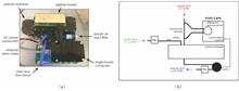
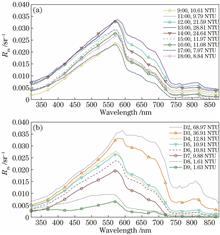
Based on a comprehensive marine scientific survey conducted in the sea area adjacent to the Yangtze Estuary from May 27 to May 31, 2018, a fixed point and continuous spectrum observation with the ship-based underway apparent spectrum observation system is carried out. Simultaneous observation results of a rapid multi-parameter water quality meter and an acoustic Doppler current profiler are also incorporated to study the high-frequency variation of the suspended particulate matter (SPM) and its influencing factors. The results show that the SPM concentration in the sea area adjacent to the Yangtze Estuary demonstrates high-frequency variations and significant influence by the tide. During the ebb period, the SPM concentration at the fixed station distinctly increases first and then decreases,with high value corresponding to the high current velocity. Underway transect observation results exhibit obvious regional differences in the variation characteristics of the SPM in a short time. In a shallower area, the local resuspension process plays a dominant role, with a close relationship between SPM concentration and the current velocity. In contrast, the concentration variation of the SPM in farther offshore areas with deeper depth may be related to the Yangtze River diluted water process.
The calibration results of the transmissometers cannot be traced to the definition of meteorological optical range (MOR) of the World Meteorological Organization. How to realize the spectrum simulation of the 2700 K incandescent lamp in the MOR definition has become a key issue that needs to be solved urgently in the calibration technology of the transmissometers, so the spectral simulation method of calibration light source of the transmissometers is studied. First, the influence of spectral mismatch on the calibration of the transmissometers is analyzed theoretically, and the basis for discriminating the spectral distribution of the light source that meets the calibration accuracy requirements of the transmissometers is established. It is concluded that the spectral simulation errors of the calibration light sources of the transmissometers should be better than ±5.5%. Then, based on a transmissometer calibration light source system with digital micromirror device (DMD), and on the basis of genetic algorithm, a spectral simulation method based on a uniform division mechanism without residues is proposed. On the premise of dividing uniformly the array surface of DMD micro mirrors into 800 columns, the number of fitting units is increased by uniformly dividing the DMD array surface, and and the spectral simulation of absolute color temperature of 2700 K is realized. Finally, the spectral distribution of the calibration light source corresponding to 20, 50, and 80 basic spectral fitting units is tested, and the uncertainty is analyzed. The test result show that the spectral simulation error of the calibration light source corresponding to the 80 basic spectral fitting units is ±5.3%, and the expanded uncertainty is 4.04%.
Synthetic aperture lidar has the advantage that the imaging resolution is independent of the detection distance. Compared with microwave, laser has a wavelength at least 3 orders of magnitude smaller. Thus, synthetic aperture lidar can achieve imaging with a higher resolution. However, due to the shorter wavelength, it is also more vulnerable to the phase error introduced by the system itself, which results in imaging blur. To eliminate the influence of this error on imaging, the paper adopts an optical phase-locked loop (OPLL) technology to suppress the random phase noise of the coded synthetic aperture lidar system. At the transmitting end, the laser signal is modulated by an electro-optic modulator driven by the coded signal for detecting the target. At the receiving end, the received echo signal and the local oscillation light are subjected to orthogonal demodulation. The proposed coded synthetic aperture lidar based on OPLL works at the 1550 nm band. Its modulation bandwidth is 1.25 GHz, and the pulse repetition frequency is up to 1.2 MHz/s. The experimental results show that the random phase fluctuation of the system is greater than 100 rad without OPLL. In the presence of OPLL, the phase fluctuation of the internal system is smaller than 0.1 rad. To sum up, the OPLL technology greatly improves the phase stability of the system and the synthetic imaging accuracy in the azimuth direction.
The space object common-view observation by two photoelectric telescopes can locate the space objects, and can solve the problem of initial orbit determination of the short-arc angle measurement data of the photoelectric telescope. However, its positioning accuracy is related to the observation geometry between the space objects and two photoelectric telescopes. First, the positioning error of space object common-view observation is analyzed, and then the analytical expression of root mean square error is derived. Finally, the simulated common-view observation data are generated based on Changchun and Shanghai Sheshan stations,combined with CPF (Consolidated Prediction Format) ephemeris of low-orbit laser stars with different orbital heights, which are used to analyze the positioning and orbit determination accuracy of space object common-view observation. The results show that the positioning accuracy of the two optoelectronic telescopes for low-orbit space objects can reach 100 m, and the positioning data is used to determine the initial orbit, the semi-major axis error of the orbit is less than 10 km.
Aiming at the problems of large path loss and difficult site selection of ultraviolet non-line-of-sight communication in rugged terrain environment, a method for solving the optimal receiving and transmitting elevation angles of ultraviolet non-line-of-sight transmission based on a digital elevation model (DEM) is proposed. Based on the ultraviolet non-line-of-sight single scattering model, the relationship between path loss and receiving and transmitting elevation angles is studied. Aiming at the original DEM data of different terrains, the resolution is improved by interpolation, and the tangent transmission scheme is proposed. The influences of the positions and elevation changes of the receiver and transmitter on the path loss of the communication system are studied by using the sequential traversal method. The simulation results show that the path loss is an increasing function of the receiving and transmitting elevation angles in the range of [10°,80°]. After using the inverse distance weighted interpolation method to improve the data resolution, the path loss is reduced by 0.014 dB, 0.043 dB, and 0.385 dB, respectively, compared with the original data. When it is arranged according to the tangent transmission scheme, the path loss of the communication system is minimal, and the designed simulation program can provide support for the scientific layout of the receiving and transmitting stations.
In order to study the correlation between cloud droplet spectrum dispersion and cloud microphysical parameters, an observation technique based on short pulse modulated laser based on field programmable gate array, high resolution microscopic optical system, and coaxial digital holographic interferometry is proposed. The minimum size of cloud droplet detected by proposed technique is 2 μm, and the complete spectrum width data of cloud droplet can be obtained. Under different aerosol concentrations for three consecutive days in an expanding cloud chamber, the three-dimensional positions and diameters of cloud droplets during the generation and elimination process are observed, and the cloud microphysical parameters are calculated by using the observation results. Furthermore, the positive correlation between the dispersion of cloud droplet spectrum and cloud microphysical parameters in the process of generation and dissipation is analyzed. By comparing the dispersion distribution of cloud droplet spectrum under different aerosol number concentrations, it is concluded that with the increase of cloud droplet concentration, the value range of the dispersion will gradually decrease, and the dispersion will decrease relative to the fitting line.
Due to the limitation of measurement methods, the existing radiation calibration system can only realize radiation measurement when the transmittance of the optical system of small-medium infrared imaging simulator changes, but not when the field-of-view aperture of large infrared imaging simulator changes. Aiming at the problem that part of the simulation state of the large-scale infrared imaging simulator cannot be evaluated, a measurement method based on imaging/light intensity change response is proposed, and a new infrared radiation calibration system is designed. After the development of the system is completed, a multi-parameter calibration method is proposed to meet the requirements of multi-radiation parameter measurement for infrared imaging simulator. The irradiance of the system is 6×10 -10-7×10 -4 W/cm 2, the working band is 2.05--2.55 μm and 3.70--4.80 μm, and the measurement uncertainty is 1.88%. Finally, the new system is used to calibrate the output radiation of a large-scale infrared imaging simulator under different simulation states. The calibration results show that the new method and new system can make the large-scale infrared imaging simulator realize multi-parameter measurement in full simulation state.
Light passing through scattering medium will be scattered and result in a random speckle pattern on the focal plane of an imaging system. So we cannot directly observe the spatial and multi-spectral information of an object behind the scattering medium. Optical memory effect based speckle correlation imaging can realize the reconstruction of the object passing through the scattering medium. However, the previous research mainly focuses on the reconstruction of images at a single wavelength, and the spectral information of targets is easily dropped during the imaging process. In this paper, a multi-spectral scattering imaging method using snapshot micro-filter array multi-spectral detectors is proposed, and the imaging results of objects passing through the scattering medium under the wide-spectrum xenon light source illumination are obtained experimentally. A method of multi-spectral information reconstruction for objects passing through the scattering medium based on optical memory effect is proposed, and the detection imaging of multispectral information hidden behind the scattering medium is realized. Since the multi-spectral detectors provide low imaging quality, an image pre-processing method is proposed based on the autocorrelation to improve multispectral imaging quality of penetrating scattering media.
Cloud camera is designed to perform cloud recognition and cloud coverage discrimination of the target area, and it adopts the threshold method for cloud detection. To satisfy the accuracy of cloud detection, it is important to determine the relationship between the response value of the detector and the radiance. We take the Bayer array based plane array color CCD camera adopted by the cloud camera as the research object, analyze its imaging process, and find that the radiation response spectra of R, G, and B channels overlap. Based on this phenomenon, a multi-channel CCD detector radiation response calibration model is established. For the R and B channels used by the cloud camera, the 747 nm LED and 443 nm LED are used as the light sources of the integrating sphere, and the minimum, typical, and maximum values of spectral radiance are set. The absolute radiation response calibration experiment of the cloud camera is carried out under the single light source condition to determine the corresponding absolute radiation response coefficients, and the correctness of the proposed radiation response calibration model is verified under the dual light source condition. This method eliminates the calibration uncertainty caused by the detector response aliasing and effectively improves the accuracy of absolute radiation calibration.
After analyzing the traditional calibration model for target deviations of photoelectric theodolites and the characteristics of photoelectric theodolites with multi-field of view stitching, we derive a calibration formula for target deviations of photoelectric theodolites with imaging systems that have large collimation errors and zero offsets according to the principle of coordinate transformation. The above calibration formula and target simulator pointing are used to reversely deduce the calculation formula of target deviations of photoelectric theodolites with large collimation errors and zero offsets. The pointing calibration coefficient of the imaging system is solved through its actual target deviation. A verification test shows that the proposed approach breaks through the limitations of the existing distortion correction model and can be applied to pointing calibration of the imaging systems of photoelectric theodolites with multi-field of view stitching. The measurement system with a 2×3 externally stitched array discussed in this paper has a collimation error of 11.26° and a zero offset of 18.08°. Both the horizontal and vertical pointing errors are less than 1/5 pixel after the system is calibrated by the pointing calibration method for photoelectric theodolites with multiple externally stitched imaging modules.
There is a good correlation between the amount of variable fluorescence and the number of viable algae cells. However, under the conditions of different species, size, and growth cycle of phytoplankton, there is a significant difference in the amount of variable fluorescence of single algae cell, so there will be a big error in calculating the number of viable algae cells by using variable fluorescence intensity directly. Therefore, an analytical method of viable algae cells in water based on variable fluorescence statistical distribution is proposed. According to the characteristic that the distribution shape of the number of cells in the subsample is consistent with the variable fluorescence amount, the distribution shape of the variable fluorescence amount is used to directly calculate the number of viable algal cells in the sample. The results show that under the condition that the variable fluorescence amount of single cell of phytoplankton changes 44 times, the cell density of viable algae cells calculated by the variable fluorescence statistical analysis method is basically consistent with the microscopic results. The correlation coefficient of linear fitting between them is above 0.93, and the average absolute value of relative error is between 5.98% and 16.94%. The results show that the proposed method basically solves the effect of variable fluorescence of algae single cell on the counting results of viable algae cells.
Based on a monolithic transceiver chip, a lens-assisted beam scanning lidar system is built. The monolithic transceiver chip is fabricated based on silicon-based integration technology, which integrates a 1×4 optical switch and 2×2 transceiver array. The transceiver consists of a grating transmitter in the middle and a surrounding U-shaped photodetector. The experimental results show that the response time of optical switch is about 5.4 μs, and the photocurrent response of the transceiver is 0.3 A/W. Combined with our self-developed scanning electronic control device with the response time of 300 ns, a frequency modulated continuous wave lidar system is realized, and the ranging experiment is carried out in the range of 1 m.
When a laser beam passes through a transparent scattering medium, a speckle field is usually generated. The phase of the incident beam can be adjusted proactively by using feedback wavefront control technique, and the speckle can be formed into focused speckle. When there is strong noise interference, most of the existing feedback control algorithms have the problem of unsatisfactory regulation effect. Therefore, a feedback wavefront regulation method based on genetic gradient particle swarm optimization algorithm is proposed for strong noise environment. This method does not rely too much on the previous optimization information, but combines the function of gradient rapid search and gene cross mutation to realize the laser beam regulation in noisy environment. The effects of initial parameters (adjustment factor, mutation rate, crossover rate, etc.) and search ability of gradient particle swarm optimization on regulation effect are analyzed by comparing with traditional algorithm. The results show that under the strong background stray light noise in the bright room, the genetic gradient particle swarm optimization algorithm can achieve better focusing effect in less iterations.
Vicarious calibration in large and uniform sites by the reflectance-based method is currently a common on-orbit calibration method. The limited number and low reflectivity of uniform sites in China have restricted calibration frequency and accuracy. The gray-scale target method has achieved high-precision radiometric calibration in a uniform site, but how to break through the single environmental background of a large uniform site to achieve high-frequency calibration is still a tough problem. On the basis of the classic irradiance-based method, this paper proposes an improved irradiance-based method suitable for gray-scale targets, analyzes a method of on-orbit radiometric calibration in complex environments, and experimentally verifies the method on an optical satellite. The results show that the proposed improved irradiance-based method, with a maximum difference of less than 3.5% from the reflectance-based method, can achieve on-orbit radiometric calibration in a complex background. It provides a technical approach for high-frequency and high-precision on-orbit radiometric calibration of optical satellites in China.
The polarization sensitivity of the radiative transfer link will affect the accuracy and subsequent application of the remote sensing data of the medium resolution spectral imager (MERSI), so it is necessary to invert, analyze, and quantitatively remove the polarization sensitivity to improve the accuracy of radiometric calibration. Aiming at the MERSI in orbit, the region with large polarization degree of ocean scene is selected. Through the preprocessing of satellite observation data and environmental data, the sea surface radiation state is described based on the probability density model of ocean surface three\dimensional wave slope and Fresnel reflection law. 6SV radiative transfer simulation tool is used to analyze the influence of atmosphere on polarized radiation state. By coupling it with the sea surface radiation state, the atmospheric top polarized radiation state can be obtained, and the inversion of the polarized radiation characteristics of MERSI can be realized. The polarization radiation characteristics of MERSI in specific wave band are analyzed experimentally, and it is found that the polarization degree of MERSI is asymmetrically distributed with the change of satellite zenith angle, and the reflectivity error is stable with the change of satellite zenith angle and polarization degree. The variation law of polarization sensitivity of MERSI under different observation geometry and wind direction is analyzed.
Ten typical radiometric calibration sites are selected for radiometric calibration and instrument performance tracking in northwest China. Simultaneous observation of reflectivity spectrum is realized by ground hand-held spectrometer and low-altitude unmanned aerial vehicles (UAVs)during satellite transit. The reflectance spectral differences of multiple sites are compared systematically, and the spectral characteristic analysis and parameter modeling of multiple sites are carried out. The spectral shape of the same site varies little at different time in one day, and the spectral angle is less than 5°. The variation of spectral amplitude is mainly affected by solar zenith angle and atmospheric conditions, and the spectral amplitude varies little at the same time in different days. The spectral shapes and amplitudes of different sites are quite different. The spectral curves of the same site at different observation scales are basically the same. Through the analysis, it is found that when the wavelength is less than 1100 nm, the spectral curves of all desert sites are similar to the curves of triangular arctangent function. Based on the arctangent function, the surface reflectance spectral modeling is carried out. The root mean square error of the measured and simulated spectra of each site is within 0.6%, and the correlation coefficient is above 0.99. The results show that the four-parameter spectral model can accurately describe the reflectance spectra of desert sites. The surface reflectance calculated by the model is used to calibrate the FY-3D medium resolution spectral imager (MERSI) site instead of the measured surface reflectance, it is found that compared with the results calculated based on the measured spectra, the relative deviation of each band of MERSI obtained by the model is less than 3%, indicating that the desert four-parameter reflectance spectral model can be well applied to the calibration of MERSI.
In order to quantitatively evaluate the effect of log-normal spectral distribution assumption on retrieval of cloud optical thickness (COT) and effective particle radius (Re), the reflectance of water clouds with log-normal spectrum and modified Gamma spectrum was simulated for the 2nd and 5th channels of the AGRI (Advanced Geosynchronous Radiation Imager) onboard FY-4A satellite by the RTTOV (Radiative Transfer for the TIROS Operational Vertical Sounder) model developed by the European Center for Medium-Range Numerical Weather Forecasts. The variation characteristics of water cloud reflectivity with COT and Re under these spectral distribution assumptions were analyzed. On this basis, the look-up tables of COT and Re under two kinds of spectral distribution conditions are established, and the influence of cloud droplet spectral distribution type on cloud parameter inversion results is quantitatively analyzed based on a primary convective cloud in summer of 2020. The results indicate that for the 2nd channel, reflectance difference under the assumption of two cloud droplet spectra is within 0.1%--2%, whereas for the 5th channel, the reflectance calculated with the modified Gamma cloud droplet spectrum is 10%--20% lower than that calculated with the log-normal cloud droplet spectrum. The retrival results show that the effective particle radius reff retrieved with the log-normal cloud droplet spectrum is larger than that retrieved with the modified Gamma cloud droplet spectrum. The former is concentrated in 15--35 μm, while the latter is within 10--30 μm. The differences of COT retrieved with the two cloud drop spectra are relatively small, ranging from -2% to 5%.
Air pollution not only affects climate change, but also seriously threatens human life and health. In the background of “double carbon”, greenhouse gas emission reduction and air pollution control have significant synergy, and they have the same roots and both involve changes in atmospheric composition. The solution of atmospheric environmental problems depends on the development of environmental monitoring technology. Spectroscopy monitoring technology has obvious advantages in the field of atmospheric stereoscopic monitoring and has become the leading direction of the development of environmental monitoring technology based on its strong scalability, non-contact, high sensitivity, and wide detection targets. At present, a series of mature atmospheric optical monitoring technologies, such as differential optical absorption spectroscopy, lidar technique, cavity ring-down spectroscopy, Fourier transform infrared spectroscopy, tunable diode laser absorption spectroscopy, and laser induced fluorescence technology by gas expansion, have been developed based on satellite, ground-based, and mobile platforms. In addition, the atmospheric environmental space-air-ground integrated stereoscopic monitoring technology based on multiple platforms has played an important role in pollution and carbon reduction. Promoting the localization of monitoring equipment and the monitoring technology to stereoscopic, automated, and intelligent applications through interdisciplinary integration has become the main development direction of atmospheric environmental optics in the future.
The detection of cloud macro- and micro-parameters is of great significance to the study of cloud physics and climate change. Lidar is an effective scientific instrument to detect cloud macro- and micro- parameters with high temporal and spatial resolution. This paper reviews and summarizes the main technologies and research progress of lidars in cloud parameter detection, discusses the shortcomings and limitations of lidars in cloud detection and the key problems to be solved in cloud detection application, looks forward to the application potential of lidars in cloud detection in the future, and puts forward the research ideas and schemes. The content involves the multi-wavelength and polarization lidar technology for cloud detection and cloud phase recognition, the lidar technology for cloud temperature, humidity, wind speed, wind direction, vertical air flow detection, and so on. The application case of lidars for cloud precipitation potential detection is analyzed and introduced. Lidars have good penetration and fine detection advantages for detecting primary clouds and thin clouds, but for thick clouds such as strong convective clouds, it needs to be combined with other detection instrument, such as a microwave radar, and carry out research on multi-source data fusion technology, so as to realize fine monitoring of the whole life cycle of clouds. With the development of laser and optoelectronic technology and big data and artificial intelligence technology, lidar technology is becoming more and more reliable. Lidar products for system stability, reliability, and detection capability required for business applications will be paid more and more attention by industry experts in the field of meteorology and environment, and will play a more and more important role in the field of cloud detection.
Clouds are the main regulators of Earth’s radiation budget, water cycle, and biochemical cycle. Since the launch of the first human meteorological satellite (TIROS) in 1960, passive satellite remote sensing has developed into one of the most efficient means to obtain cloud observation data. Passive satellites have the characteristics of large observation range and long time span,in which the remote sensing imagers using visible and infrared bands (0.40--15 μm) have higher spatial and temporal resolution than hyperspectral and microwave imagers. First, summarizes the observation characteristics of passive satellite observation sensors based on visible and infrared bands for three types of sensors (multispectral imagers, multi-angle polarization imagers onboard polar-orbiting satellites and multispectral imagers onboard the new generation geostationary satellites) are summarized. Then, the principles and application methods for cloud parameters such as cloud detection, cloud phase, cloud top parameters, cloud optical and microphysical parameters are introduced. Finally, some thoughts are provided for the remote sensing study of cloud characteristics of passive satellite visible and infrared data through summary and prospect.
Traditional monitoring methods for typical marine pollution and disasters such as oil spill and red tide have three major problems. Firstly, the detection distance is reduced by sea fog. Secondly, the distinguishing ability is reduced by flare. Thirdly, the recognition ability is reduced by stray light. In this paper, by comparing the advantages and disadvantages of various optical monitoring methods, a multi-dimensional optical monitoring method of combining spectrum, polarization, and infrared detection is put forward. The current research status and shortcomings of inversion methods for generation, transmission, acquisition, processing, and identification of multidimensional characteristics of typical ocean targets are analyzed. Five important development directions including the acquisition mechanism of multidimensional optical information of ocean targets, the generation mechanism and transmission evolution mechanism of multi-dimensional optical characteristics under complex sea conditions, the decomposition of multi-dimensional high-resolution information of ocean targets, the reconstruction and enhancement methods, and the multi-dimensional high-precision recognition and inversion methods of ocean targets are proposed, and the technical route and solution are pointed out. Then, the multi-dimensional optical monitoring system is designed. Finally, qualitative and quantitative controlled tests for five kinds of oil spill and two kinds of dominant species of red tide are carried out in outdoor. The oil species and dominant species of red tide are classified by using polarization detection. This experiment laid a foundation for further research and application of airborne multi-dimensional high-resolution ocean optical monitoring systems.
Suspended particles are everywhere in ocean and play important roles in almost all ocean processes including physics, chemistry, biology and geology deposition, and ocean carbon cycle in particular. However, for a long time, current technology for in-situ observation and fine classification of marine micro-particles is still far from satisfactory. Polarized light scattering measurement is sensitive to the size, morphology, and subcellular microstructure of suspended particles. The measurement results can be used for quantitative characterization and fine classification of complex marine particulate structure characteristics and even the physiological state of marine organisms. Realizing in-situ dynamic monitoring of polarized light scattering has shown attractive application potential in the field of marine environmental monitoring. In this paper, we present a brief summary of current techniques for marine particle detections and a more detailed introduction on the principle, technique, and applications of polarized light scattering for the detection and fine classification of marine particles, followed by a discussion on future prospective of the fields.
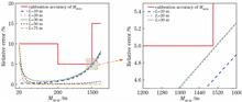
The geostationary interferometric infrared sounder (GIIRS) is a key payload on the geostationary FengYun-4B meteorological satellite of China. Because the GIIRS can measure atmospheric upwelling hyperspectral infrared radiance, it can be used to retrieve atmospheric temperature and humidity profiles and can also be applied to numerical weather prediction models. For the prediction of GIIRS’ post-launch performance, a series of blackbody calibration experiments are performed before launch in a laboratory thermal vacuum tank in a ground laboratory to test the radiometric performances of the instrument, including sounder sensitivity, radiometric calibration accuracy, and dynamic observation range. The noise equivalent differential radiance (NEdR) in the long-wave infrared (LWIR) band is less than 0.5 mW/(m 2·sr·cm -1), and that in the mid-wave infrared (MWIR) band is less than 0.1 mW/(m 2·sr·cm -1). Both NEdRs meet the sensitivity design requirements. As for the radiometric calibration, the average calibration difference in the LWIR band is improved from 1 K to 0.2 K after the nonlinearity correction. In addition, in the observation range of 220--315 K, the calibration differences meet the design requirement of 0.7 K. The MWIR band is susceptible to noise when the instrument is used to observe low-temperature targets. Nevertheless, the calibration differences also meet the 0.7 K index requirement in the dynamic range of 260--315 K.