


Please enter the answer below before you can view the full text.

Journal of Atmospheric and Environmental Optics
Co-Editors-in-Chief
Wenqing Liu

2025
Volume: 20 Issue 2
9 Article(s)

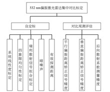
BU Zhichao, YIN Zhenping, MAO Song, WANG Longlong, WANG Anzhou, ZHANG Jiangtao, ZHAO Bing, YI Yang, CHEN Yubao, and WANG Xuan
In view of the development of aerosol lidar network in megacities in China, the calibration methods and quantitative methods of aerosol lidar network are continuously studied and solved by referring to the calibration strategy of the European Aerosol Research Lidar Network (EARLINET). In September 2021, a self-calibration/intercomparison and quantification study was carried out for six 532 nm polarization lidars developed by different units at the Southern Suburb Observatory of Beijing. After self-calibration of the key performance of the lidars, such as optical geometry calibration, dark noise, Rayleigh fit and effective detection range, the intercomparison observations with the reference lidar were carried out, and the quality evaluation of polarization performance of the lidars to be calibrated was carried out by using the strategy of statistical analysis of system deviation and standard deviation. The results show that the averaged relative deviation of horizontal polarization signal P of 532 nm lidars after self-calibration can be controlled within 10% in the height range of 0.5–2 km, and within 20% in the height range of 2–5 km. While the original signal of vertical polarization S shows a big difference of over 50%. After being transferred to the backscattering coefficient, the mean relative deviation and standard deviation can be controlled within 10% in the height range of 0.5–2 km, and within 20% in the height range of 2–5 km. The method of self calibration and intercomparison with the reference lidar is helpful to quantitatively evaluate the observation performance of 532 nm polarization lidar in China, and also can be used as a routine quality control method to improve the consistency of the signal products of atmospheric lidar network and the accuracy of the retrieval products, laying the foundation for atmospheric aerosol lidar to enter the quantitative network observation.
Mar. 28, 2025Vol. 20 Issue 2 123 (2025)
WANG Zhiru, CHENG Yin, GUI Huaqiao, ZHANG Jiaoshi, YANG Ming, and LIU Jianguo
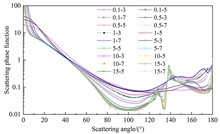
Weather phenomenon recognition is of great significance for transportation, agriculture and human daily activities, and automatic weather observation technology based on optical principle has broad application prospects. At present, the distinction of fog and haze by the existing meteorological instruments is mainly based on visibility range, with a single judgment condition, and to identify rain and snow, precipitation sensors are required, which is technically complex. In this work, based on the differences in scattering characteristics of rain, snow, fog and haze particles from different angles, a universal weather phenomenon recognition system based on forward and backward scattering principle is designed and developed, which identifies fog, haze, rain, snow and clean days through two-way scattering angle signals of 40° and 120°. Observation experiments in relatively stable environments show that, the system can realize accurate measurement of atmospheric visibility within a range of 60 m–13 km, and the correlation coefficient between the observed visibility results and the standard visibility below 5 km can reach 0.98. Moreover, it is shown that the range of the measured light intensity ratios in fog, haze, rain, snow and clean days are 0.16–0.19, 0.21–0.45, 0.11–0.15, 0.75–0.90 and 0.47–0.58, respectively, which can realize accurate differentiation of different weather types.
Mar. 28, 2025Vol. 20 Issue 2 134 (2025)
BU Qiaoli, and LI Haowen
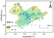
To reveal the influence of the characteristics of the boundary layer structure in Foshan City, China, during the dry season on air quality and develop more scientific pollution control measures, a comprehensive three-dimensional observation of atmospheric boundary layer structure in Foshan was carried out by using the ground-based remote sensing equipment (including wind profiler radar, lidar and microwave radiometer) at Shunde, Chancheng and Sanshui stations in Foshan. The research results show that: (1) There are significant differences in the boundary layer structure of different regions in Foshan City. For example, as the urbanization degree of Chancheng is higher than that of Sanshui and Shunde, the wind speed at the bottom of the boundary layer in Chancheng is the lowest and the horizontal diffusion condition is the worst. While Shunde, located in the south of Foshan, has more water vapor and the highest pollutant concentration, which may be related to the hygroscopic growth of aerosols. (2) The decrease of boundary layer height leads to a sharp increase in pollutant concentration near the ground. (3) In Foshan area, there is generally a small wind layer with wind speed below 2.6 m/s near the ground layer, and the thickness of the small wind layer has an obvious diurnal variation, with the maximum thickness in the early morning, which is prone to pollution. In addition, the thickness of the small wind layer is highly correlated with the concentration of fine aerosol particles, and the prediction of the small wind layer thickness can be carried out in the later stage.
Mar. 28, 2025Vol. 20 Issue 2 145 (2025)
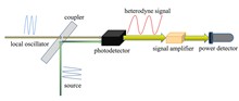
LI Renshi, DENG Hao, KAN Ruifeng, YANG Chenguang, LIU Hao, XU Zhenyu, and ZHANG Xianyi
A high resolution laser heterodyne spectroradiometer, with a distributed feedback semiconductor laser operating near 1571 nm as the local oscillator and the sunlight as the signal light source, was built in this work to develop an efficient measurement method of atmospheric CO2 vertical profiles. Taking a narrow linewidth semiconductor laser (2 MHz) instead of sunlight as a simulated signal light source to measure the linear function of the developed system, the spectral resolution with 0.008 cm-1 was obtained. The solar tracker is used in the spectroradiometer to track and collect sunlight, and sunlight is modulated by a optical chopper and mixed with the local oscillator in a fiber to achieve heterodyne detection, and then the CO2 heterodyne absorption spectrum is obtained through demodulation using a lock-in amplifier. Finally, the experimentally measured CO2 heterodyne spectrum is normalized and fitted to retrieve the atmospheric CO2 vertical profiles by using the self-programmed optimal estimation algorithm. The results show that the total error of inversion with 9.5% has been achieved, and the variation trend of CO2 vertical profile agrees well with that reported in existing literatures, which proves the feasibility of the system for atmospheric CO2 vertical profiles measurement. In the future, we will further upgrade the system and realize long-term observation of atmospheric CO2 profiles in the region.
Mar. 28, 2025Vol. 20 Issue 2 158 (2025)
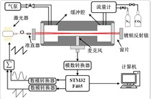
YANG Zijian, LI Lin, GUO Guqing, GONG Ting, LIU Qiang, TIAN Yali, SUN Xiaocong, QIU Xuanbing, and LI Chuanliang
Based on a 1.578 μm distributed feedback semiconductor laser, a resonant photoacoustic spectroscopy measurement system for carbon dioxide (CO2) detection is built in this work. In the system, the wavelength is modulated using the optimal frequency of 800 Hz and tuned using sawtooth wave with the value of 1 Hz. In order to improve the intensity of photoacoustic signal, a Herriott type multi optical path cell for photoacoustic detection is designed with the maximum reflection number of 42 times and the corresponding optical path of 8.4 m. The experimental results show that the photoacoustic signal is increased by 11.5 times by multiple reflections, which improves the detection sensitivity of the system. By estimating the signal-to-noise ratio of 196.42 mg/m3 CO2 photoacoustic signal, the limit detection sensitivity of the system is obtained to be 7.26 mg/m3. Further, the Kalman filtering algorithm is used to optimize the continuous acquisition of photoacoustic signals, which improves the robustness of the system, and the detection accuracy of the system is improved by 1.36 times. The system is used to continuously monitor 982.14 mg/m3 standard CO2 gas for 10 hours, and the fluctuation of the measured mass concentration is less than 1.7%, which verifies the accuracy and reliability of the developed CO2 sensor system. This work provides an effective method for real-time measurement of CO2 and other trace gases by near-infrared laser.
Mar. 28, 2025Vol. 20 Issue 2 168 (2025)
YANG Huirong, HE Nanteng, BU Lingbing, MO Zusi, FAN Zengchang, ZHOU Xiaomeng, and SU Xin
High concentration of atmospheric particulate matter can cause the reduction of atmospheric visibility and has a negative impact on human health. Therefore, continuous monitoring, estimation and prediction of the temporal and spatial variation characteristics of particulate matter concentration are of great significance for environmental pollution assessment and treatment. In this work, by using the meteorological data of Rencheng District, Jining City, the air quality data from the Electrochemical Plant Station of Jining national environmental air quality monitoring point and the surface aerosol extinction coefficients inverted from lidar signal over Rencheng District from December 2021 to February 2022, a model of particle concentration estimation is established based on machine learning. First, the sliding average of 100 of the air quality index (AQI) in the previous 24-hour is used as the threshold value to divide the samples into two background conditions: clean and polluted. Then, the importance of input factors is ranked using random forest (RF) algorithm, and according to this importance rank, the factors are put into RF, mind evolution algorithm-back propagation neural network (MEA-BPNN), generalized regression neural network (GRNN) and wavelet neural network (WNN) models, respecitively. And then, by comparing the root mean square errors (ERMS) of different models, the optimal model and the optimal number of input factors for particulate matter concentration inversion under different atmospheric background are established. Finally, the particle estimation model developed is applied to the actual atmospheric observation data to evaluate the horizontal distribution of particle concentration under different atmospheric backgrounds based on the optimal model and input factors.
Mar. 28, 2025Vol. 20 Issue 2 176 (2025)
FAN Jiafu, YU Yuanqin, GU Xuejun, and TANG Xiaofeng
Aqueous reactions play an important role in the formation of secondary organic aerosols, and related research has become one of the hotspots in the field of atmospheric aerosols. The typical aqueous reaction system of glyoxal/ammonium sulfate was selected in this work. Based on a smog chamber simulation system, the particle size and composition of glyoxal/ammonium sulfate aqueous secondary organic aerosol were measured using a scanning mobility particle sizer and a vacuum ultraviolet photoionization time-of-flight mass spectrometer. By comparing with the reaction under dark conditions, the influence mechanism of ultraviolet light on the particle size and composition of glyoxal/ammonium sulfate aqueous secondary organic aerosol under different relative humidity was explored. It shows that ultraviolet light can induce the photolysis of light absorbing substances such as imidazole and imidazole-2-carboxaldehyde in the products of glyoxal/ammonium sulfate aqueous reaction, and relative humidity can affect their photolysis process. Under low and medium relative humidity conditions, the photolysis rate increases with the increase of relative humidity, while under high relative humidity, the photolysis phenomenon almost does not occur. These results are not only helpful to understand the optical properties of atmospheric secondary organic aerosols, but also provide an important reference for the modification of regional climate models.
Mar. 28, 2025Vol. 20 Issue 2 188 (2025)
XU Shenshen, and LI Chonggui
Based on the Landsat images of June 11, 2004, June 25, 2009, June 27, 2014 and May 22, 2020, the single-window algorithm was used to invert land surface temperature in Shijiazhuang City, China, and to analyze the spatiotemporal dynamic variation characteristics of land surface temperature, and then the spatiotemporally and geographically weighted model was used to explore the mechanism of each driving factor. The results showed that: (1) In the four panoramic images studied, the maximum land surface temperature in Shijiazhuang area showed an upward trend from 2004 to 2020 with a slope of 1.997 ℃/a, and reached the maximum in 2020. (2) With the passage of time, the land surface temperature showed an overall upward trend under different topographic factors. Spatially, land surface temperature first increased and then decreased with the increase of elevation, and on the other hand, it increased with the increase of slope, but there were differences in different slope directions, with the maximum difference of land surface temperature between the negative slope and the sunny slope of 0.566 ℃. (3) Compared with ordinary least square regression and geographically weighted regression, spatio-temporal geographically weighted model is the optimal model with multiple driving factors, in which the driving force of vegetation index and relative soil moisture on land surface temperature is the largest, while the driving force of monthly total precipitation is the weakest. The results of this study can provide reference for urban layout planning and ecological environment improvement.
Mar. 28, 2025Vol. 20 Issue 2 199 (2025)
FAN Qiang, WEI Yu, and LUAN Xiaoze
Object-based image analysis (OBIA) method has become the mainstream method of high-resolution remote sensing image classification due to its advantages of considering object spectrum, shape and texture feature information. Image segmentation is an important step of OBIA method, which determines the accuracy of image classification. The same image has a variety of ground features, and a single segmentation scale will cause the phenomenon of image undersegmentation or wrong segmentation, therefore, different image segmentation scales are often required in practical applications. Taking the fractal network evolution algorithm as an example, this paper proposes a remote sensing image classification algorithm combining quadtree structure and scale estimation. In this algorithm, the image region is firstly divided by using the characteristics of uniform detection and segmentation of quadtree structure, the quantitative estimation of segmentation scale of each region is realized by using the spatial segmentation scale estimation method of statistical average local variance and the attribute segmentation scale estimation method of statistical local variance histogram, and then the regional images are segmented at multiple scales using the fractal network evolution algorithm. Finally, the training samples are determined through visual interpretation, and the nearest neighbor supervised classification method is used to realize image classification. The experimental results show that compared with the classical object-based classification algorithm, the classification accuracy of the proposed algorithm is improved by 1.2% and the kappa coefficient is improved by 0.036. Moreover, the problems of linear feature extraction fracture and classification error caused by wrong segmentation and under segmentation in classical algorithm can be effectively avoided in the proposed algorithm.
Mar. 28, 2025Vol. 20 Issue 2 211 (2025)
© Copyright 2018-2021 | Chinese Laser Press.
All Rights Reserved 沪ICP备15018463号-20