


 View fulltext

2024
Volume: 45 Issue 4
15 Article(s)

Shuo WANG, Wenlong BAO, He JIA, Kang LIU, Zhen WANG, and Shuyi GAO
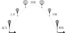
In the 21st century, commercial space is an important engine for the economic development of the world space industry. Suborbital manned flight, as the commercial extension of manned space flight, reflects the characteristics of low cost, high reliability and good convenience, and is a hot track for commercial space pursuit. In this paper, the development status of suborbital manned flight in the world is investigated, and the three forms of suborbital manned flight are compared and analyzed from the aspects of feasibility, user demand and economic benefit. The result shows that manned spacecraft program is the most suitable development direction of suborbital manned flight; the subsequent of manned spacecraft needs to focus on the breakthrough of reusable rocket technology, escape rescue technology and non-destructive recovery technology.
Sep. 30, 2024Vol. 45 Issue 4 1 (2024)
Yifan WANG, Wei JIN, and Hongbiao LIU
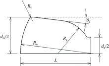
In order to obtain the optimal aerodynamic shape of the return capsule under hypersonic conditions during the overall scheme design stage of the small cargo return capsule, an optimization platform is built based on Isight software, and an optimization model is established with the lift-drag ratio and drag coefficient as optimization objectives and the head stagnation point heat flux, cargo hold volume utilization rate and cargo hold volume as constraint conditions. The aerodynamic shape of small cargo reentry capsule is optimized. In order to improve the precision of single objective optimization, different combination optimization algorithms are proposed to give full play to the advantages of global optimization algorithm being insensitive to initial value, strong global convergence, fast convergence and high precision of numerical optimization algorithm. The optimization results show that the error of the aerodynamic parameters calculated by the model based on modified Newton theory is less than 5%, and the prediction accuracy is high. The lift to drag ratio is increased by 27.7% with the single objective optimization. It is found that in order to obtain the maximum volume, we should not only use the volume ratio as the constraint condition, but also add the volume as the constraint condition to carry out optimization. And the single objective optimal solution is only a particular solution of Pareto multi-objective optimal solution set. Therefore, the optimization platform can be applied in the design and selection of small cargo return capsule, providing good support for the shape optimization of return capsule.
Sep. 30, 2024Vol. 45 Issue 4 9 (2024)
Ziyue CHEN, Bowen QIU, Yanjun LI, and Li YU
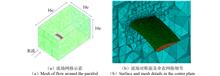
To study the aerodynamic performance of the parafoils with different platform geometries, this paper establishes numerical model of steady flow around parafoils during its glide phase. The influence of the trailing edge shape of parafoil on the flow field structure and aerodynamic characteristics under steady descent is analyzed, and the influence of the trailing edge swept forward angle on the aerodynamic performance is investigated on the basis of this study. The results reveal the following conclusions: the swept-forward parafoil has a reduced pressure at the leading edge of the upper surface, which is conducive to the reduction of drag coefficient due to pressure difference and the best aerodynamic performance, so that trailing edge with forward-swept shape is preferred for parafoil design. With the increase of swept angle, both the lift and drag coefficient decrease first and then increases, and the lift drag ratio increases first and then decreases. The flow separation increases with the swept angle, which leads to increased drag due to pressure difference, as a result, the lift drag ratio decreases. Considering the flow field structure and aerodynamic characteristics, the forward-swept platform shape with swept angle 6° can improve the aerodynamic performance best. This paper can provide some reference for the design of high gliding parafoils.
Sep. 30, 2024Vol. 45 Issue 4 18 (2024)
Jinglei LIU, Yunlong YAN, Xiaoyan PEI, Xiyun SUN, Haiye LIU, and Maoyong QIAO
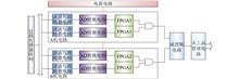
In response to the requirements of a lightweight, compact, and highly reliable commercial recoverable satellite recovery system, a recovery controller product based on a MEMS accelerometer for ballistic overload measurement are designed. It incorporates dual-core, four-process “AND-OR” logic for redundant control, and utilizes capacitive discharge semiconductor bridge igniter detonation technology for pyrotechnic device management. The ballistic overload trigger verification tests for the return process are planned. The ignition efficiency simulation analysis of the capacitive energy release system is carried out under different initial voltages, capacitor array capacitance values, and circuit resistance values. The results show that the recovery controller can achieve an overload sensing accuracy of ±0.28 g for the return trajectory under the lightweight and compact constraints, and has real-time and highly reliable control of the parachute opening logic. The optimized parameters for the capacitive discharge circuit of the semiconductor bridge igniter comprise an initial voltage greater than 24 V, a circuit resistance less than 0.3 Ω, and an initial capacitance greater than 22 μF, which can ensure highly reliable ignition control of the igniter. This design can greatly reduce the weight of the product without significantly increasing hardware consumption, and can provide reference for the design of similar electronic systems in aerospace applications.
Sep. 30, 2024Vol. 45 Issue 4 29 (2024)
Ran LI, Man XIANG, Yan JIN, and Ye XUE
Currently, earth observation satellites have the characteristics of speed, dynamism, and accuracy, making them essential monitoring tools for high-accuracy monitoring of natural disasters. However, there are numerous earth observation satellites with significant differences in their main tasks and resolutions. Rational allocation of satellite tasks is crucial for emergency monitoring of natural disasters. Based on the analysis of the requirements of natural disasters, this study proposes a satellite observation planning method for natural disasters based on temporal and spatial constraints and task priorities. By establishing a satellite planning model and optimizing it through a combination of greedy algorithms and genetic evolution algorithms, this study conducts simulation experiments to verify the reliability of the model. The results indicate that greedy algorithms and genetic evolution algorithms are suitable for the planning of Earth observation tasks for natural disasters in medium-sized and large areas respectively.
Sep. 30, 2024Vol. 45 Issue 4 39 (2024)

Nan ZHOU, and Panghe QIU
Most of the large width area-array cameras use multiple detectors stitching imaging to increase the width. In order to improve the efficiency of data use, users make a request to acquire geometrically lossless stitching products. The traditional stitching method is difficult to apply due to the small or even no overlapping area between detectors and the increased distortion after stitching. Aiming at this problem, this paper proposes a sensor corrected method based on virtual area-array imaging of the object space to realize high-precision geometric stitching for multi-detector images of large width area-array cameras. This method firstly simulates a completely ideal undistorted area-array image based on the physical structure and imaging geometric characteristics of the multiple area-array detectors of the satellite camera, and the virtual image coverage is the same as that of the original slice detector images; then, the two-dimensional orientation of the pixels of each area-array detector is strictly calibrated; finally, based on the object consistency, the pixel coordinate conversion relationship is established between the virtual image and the original image, and the pixel gray value of the original image is assigned to the virtual image to achieve seamless stitching and distortion correction. The experimental results of simulation data and on-orbit real data show that, for different detector stitching conditions and overlapping areas between detectors, the method proposed in this paper can obtain visually seamless and geometrically lossless stitched images, and the image stitching accuracy and internal geometric distortion are better than 1 pixel.
Sep. 30, 2024Vol. 45 Issue 4 48 (2024)

Shuqi YANG, Chunxiao ZHANG, Pu CHENG, and Kun XING
A method for wide-angle infrared camera on-orbit refocusing based on sub-pixel error compensation of star points is proposed to solve the problems of long refocusing cycles and low efficiency caused by atmospheric conditions, land richness, moon phase angle, and other factors. By accurately locating the centroid of star point images without atmospheric degradation and extracting clarity evaluation indicators, the method effectively avoids the influence of external factors, improves the refocusing efficiency, and ensures the refocusing accuracy. Firstly, adaptive threshold centroid method and Gaussian fitting method are used to extract centroid estimation values for star point images; According to image signal-to-noise ratio and energy concentration of star point targets to determine the optimal factor, and construct an error compensation model for accurate centroid localization; Extract the waveform full width at half maximum (FWHM) of the point spread function from the image as an evaluation index for clarity; Set up infrared images of star points with different spectral ranges and energy concentrations as on-orbit focus detection images, and use centroid method, Gaussian fitting method, and the method proposed in this paper to extract target centroids and estimate FWHM. The experimental results show that the average errors of centroid extraction for the three methods are 0.1195, 0.0107, and 0.0027, and the root mean square errors (RMSE) are 0.1210, 0.0124, and 0.0085, respectively. The method proposed in this paper has the smallest centroid extraction error and the best stability. When the energy concentration is between 0.4-0.8, the average error of centroid extraction using this method is less than 0.01, which is superior to other methods. On this basis, the FWHM average accuracy extracted by the method proposed in this article has been improved by more than three times, and is not affected by the randomness of the centroid position of star points. It has high reliability and stability for refocusing, meeting the requirements of on-orbit refocusing.
Sep. 30, 2024Vol. 45 Issue 4 58 (2024)
Xurui CHEN, Haodong YAN, Guopeng DING, Shuai ZHI, Yonghe ZHANG, Chengcheng FAN, Zhaoxiong LI, and Zhencai ZHU
Due to the interference of the harsh space environment on satellites in orbit, the images outputed by the star sensor cameras in orbit are distorted compared to those calibrated on the ground. This distortion restricts the accuracy of attitude measurement, and real-time effective image correction is difficult due to the limitations of in-orbit operating conditions, thus limiting the accuracy of the star sensors. To address these issues, this paper proposes a method for on-orbit correction of star sensor distortions. The method involves constructing a mapping dataset between the distorted coordinates of star points and the theoretical coordinates from the star catalog to train a neural network model, which fits the nonlinear distortions in star sensor imaging, achieving high-precision image distortion correction. To verify the distortion correction capability of this method, a simulated star map experiment was conducted. Through the simulation experiment, the average error between the measured coordinates of the star points and the theoretical coordinates was reduced from 0.7237 pixels to 0.0586 pixels after correction. This result indicates that the proposed correction method can significantly enhance the resolution accuracy of star sensors and has the potential for on-orbit learning capabilities and extending to other onboard payload image correction applications.
Sep. 30, 2024Vol. 45 Issue 4 71 (2024)
Dexin ZHAO, Duidui LI, Jihui CHEN, Fanchao WANG, and Chuang LI
The Directional Multi-Spectral Camera (DMC) consists of five cameras, and the imaging is independent. This imaging method makes it difficult to ensure the consistent radiation response among multiple cameras in the process of realizing stereoscopic imaging. In order to achieve the same radiation response of each camera and each CCD, a multi-camera global chromatic aberration calibration method is proposed in this paper, and the radiation correction effect of histogram on-orbit statistics method and yaw calibration method on the Directional Multi-Spectral Camera images is compared. Compared with the correction effect between cameras, the color of the five cameras corrected by the multi-camera global color difference calibration method is closer, and the relative radiometric correction accuracy of uniform objects is higher. According to the comparison of the correction effect of CCD inter-chip images, the CCD inter-chip images corrected by histogram statistics method and multi-camera global chromatic aberration calibration method show color balance, basically no chromatic aberration, and the relative radiometric correction accuracy is basically less than 3%. In conclusion, the multi-camera global chromatic aberration calibration method is more suitable for correcting the radiation problem between multi-angle and multi-spectral cameras.
Sep. 30, 2024Vol. 45 Issue 4 81 (2024)
Zhikun LIU, Kai JIANG, Xingwang QIAO, Lulu TAN, Jiajia ZHANG, and Yongtao LIU
In the military and civilian fields, the study of radar scattering coefficient has significant academic value and broad application prospects. Research on the difference between the co-polarization and cross-polarization scattering coefficient is relatively litter. P-band radar scattering coefficient data for typical objects is no publicly available. Initially, this paper studies scattering characteristics of typical objects in the L band. The relationship between radar scattering coefficient and incident angle is analyzed based on the measured data at home and abroad, and the differences between HH polarization and HV polarization are compared. Furthermore, the radar scattering coefficients of typical ground objects in P band are calculated based on the recently radar flight test. The relationship between radar scattering coefficient and incident angle is also analyzed. The differences between HH polarization and VV polarization are calculated. Lastly, radar scattering coefficient of P and L band is compared. Results demonstrate that L-bandradar scattering coefficient difference between HH polarization and HV polarization decreases with increasing incident angle. At a fixed incidence angle of 40°, radar scattering coefficient is about 10~13 dB. P-band theradar scattering coefficient decreases with increasing incident angle,which is 1-2 dB lower than L-band radar scattering coefficient. P-bandradar scattering coefficient difference between HH polarization and HV polarization decreases with increasing incident angle. The research in this paper can accumulate data for remote sensing application of P and L land radar, and provide help and reference for polarimetric SAR to retrieve target information.
Sep. 30, 2024Vol. 45 Issue 4 91 (2024)
Wenhuan YANG, Shuai ZHANG, Chao SUN, and Ao ZHANG
Aiming at the problem of computational redundancy in cost aggregation in semi-global matching (SGM), a fast cost aggregation and disparity determination method based on the minimum cost path is proposed, which includes two stages: 1) Different from SGM, the cost aggregation is conducted by finding the path of minimum cost instead of updating the matching cost. Then the cost aggregation result is transformed from the aggregation cost to a set of disparity candidate values. The amount of cost aggregation calculations is no longer related to the disparity range. 2) After all the paths are aggregated and the disparity candidate value set is obtained, the reciprocal of the sum of the absolute difference between a single disparity candidate value and other disparity candidate values is used as its support. Counting the support of all disparity candidate values, the “winner takes all” strategy is employed to determine the final disparity value after the support of all disparity candidate values are counted. The experimental results of the dense matching of ZY-3 and GF-7 images verify the effectiveness of the method, which can increase cost aggregation processing efficiency by 90% while keeping the matching results consistent with SGM.
Sep. 30, 2024Vol. 45 Issue 4 99 (2024)
Yi SHI, Zhihua MAO, Yiwei ZHANG, Haiqing HUANG, and Qiankun ZHU
The coastal zone imager carried by the HY-1 C/D satellite uses high-resolution linear pushbroom cameras, which can obtain remote sensing data with a resolution of 50 m. Realizing in-orbit geometric positioning of its images and obtaining standard image products is the foundation for subsequent remote sensing data applications. In this paper, according to the physical structure and imaging mechanism of the instrument, a strict geometric imaging model of remote sensing image of the coastal zone imager is established. We create the coordinates of the observed vector in the focal plane system under ideal conditions, and optimize the traditional geographic coordinate conversion process. The ground preprocessing experiment was conducted using real-time level 0 data received by the ground station, and the system error compensation was performed using the lake inflection point error. The results showed that the average accuracy of the positioning results obtained by the method in this paper is less than one pixel, and the positioning performance in mid to low latitude areas is slightly better than that in high latitude areas. It indicates that this method can meet the basic positioning accuracy requirements, and realize the ground target positioning of HY-1 C/D coastal zone imager images in uncontrolled areas.
Sep. 30, 2024Vol. 45 Issue 4 109 (2024)
Donghang YU, Guangyi SHI, Yukun ZHOU, Xiaochen WU, and Chuan ZHAO
Remote sensing image scene classification is a fundamental task in remote sensing image interpretation, which has important application value in land-use investigation, geologic disaster monitoring, geospatial intelligence acquisition and so on. This paper systematically summarizes and analyzes representative methods for remote sensing image scene classification. Firstly, the commonly used datasets for remote sensing image scene classification are sorted out, and the challenges and difficulties brought by the characteristics of remote sensing images to scene recognition are elaborated. Secondly, some typical remote sensing image scene classification methods are summarized, which includes hand-crafted features and deep learning. And the optimization and improvement for remote sensing image scene classification task are analyzed. Then, the performance of some mainstream methods is compared. Finally, the unsolved problems and the next research directions of remote sensing image scene classification are summarized and explored. And the research prospects of high-precision fine-grained scene classification task, high-precision lightweight algorithms, few-shot learning, and large model for remote sensing image scene interpretation are explored with the aim of promoting the remote sensing image scene classification and recognition tasks to achieve more in-depth research and a wide range of applications.
Sep. 30, 2024Vol. 45 Issue 4 124 (2024)
Flue Cured Tobacco Area Extraction of Remote Sensing Image by Integrating Lightweight ASPP and U-Net
Shufeng HAO, Yu GAO, Ping LIU, Yuang LI, Huadong ZHANG, Hongjie REN, Shuaijie TIAN, and Wentao KOU
To address the issues of low efficiency and accuracy for flue cured tobacco area extraction in remote sensing images, we propose a novel tobacco area extraction model with remote sensing images. The proposed model integrates the lightweight ASPP and U-Net framework for improving performance. The model enhances its performance in three ways: 1) integrating a lightweight atrous spatial pyramid pooling module at the junction of the U-Net encoding and decoding layers, 2) substituting the ReLU activation function with ReLU6, which can compress the dynamic range during low-precision computation and enhance the algorithm's robustness, and 3) optimizing segmentation results by developing a post-processing algorithm that constructs labeled maps through morphological hole filling. To demonstrate the effectiveness of the model, we utilize UAV remote sensing images as the experimental dataset. We also conduct comparative experiments with traditional semantic segmentation models and ablation study of the proposed model. Compared to traditional semantic segmentation algorithms such as FCN, U-Net, SegNet and DeepLabV3+, the proposed method achieves better performance, where the pixel accuracy and the mean intersection over union of the proposed model are 93.7% and 84.1%, respectively. Furthermore, the model enhances computational speed while maintaining the accuracy of segmentation.
Sep. 30, 2024Vol. 45 Issue 4 139 (2024)
Guanghua HE, Xueling HUANG, and Zhijian ZHANG
High resolution remote sensing satellite is an indispensable and effective tool in the detection of external damage, and the key to realize the identification of external damage signs is the application of change detection technology. In this paper, an object-level change detection method based on optimal scale segmentation and feature optimization is proposed. Firstly, the optimal segmentation scale is determined by scale evaluation parameters. Then, based on the results of the optimal segmentation scale, J-M distance algorithm and XGBoost model were respectively used to optimize the multi-source feature sets, and the appropriate feature sets were screened by comparative analysis. Finally, a support vector machine (SVM) classifier was used to calculate the Euclidean distance between the feature parameters and classify them, and two classification results were obtained, namely, changed and unchanged. The results show that the accuracy indexes of XGBoost model algorithm after feature optimization are all higher than the change detection results of J-M distance algorithm, and the same segmentation scale and feature set are applied to validate the change detection results in images with different resolutions, in the accuracy evaluation based on area and object, F1 scores reached 83.31% and 84.09% respectively. Meanwhile the accuracy rate exceeded 79% and the recall rate exceeded 86%, which indicates that the algorithm used in this paper can obtain higher detection accuracy under different resolutions, and the manual intervention in feature selection and feature set establishment rules is reduced, which provides effective technical support for change detection along the cable.
Sep. 30, 2024Vol. 45 Issue 4 150 (2024)
© Copyright 2018-2021 | Chinese Laser Press.
All Rights Reserved 沪ICP备15018463号-20