


 View fulltext

2024
Volume: 45 Issue 5
14 Article(s)

Jiapeng HAN... and Meifang ZHU|Show fewer author(s)
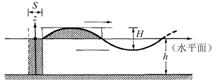
In order to study the water impact characteristics of the re-entry capsule with airbags under wave conditions, based on a combination model of a certain type of re-entry capsule and airbags, a multi-media coupling model of re-entr
Oct. 30, 2024Vol. 45 Issue 5 1 (2024)
Liang DONG... and Li YU|Show fewer author(s)
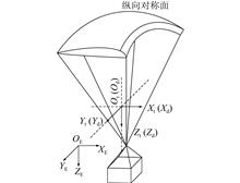
To investigate the wind effect on the flight kinematics of the parafoil system, a six-degree-of-freedom flight dynamics model considering wind interference is established. Runge Kuta method is applied to simulate the gliding perfo
Oct. 30, 2024Vol. 45 Issue 5 13 (2024)
Yifan LIU... and Libing JIN|Show fewer author(s)
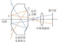
The traditional panoramic ring optical system is composed of a single lens panoramic block and a relay lens system, without an intermediate image plane and mostly used in the visible light band. It can not limit the stray light ou
Oct. 30, 2024Vol. 45 Issue 5 23 (2024)
Yuanbo ZHANG... and Jiwei ZOU|Show fewer author(s)
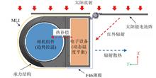
In response to the requirements for the development of mass production remote sensing satellites, an optimization strategy for the thermal control system was explored and applied to the development process of a certain batch of Ji
Oct. 30, 2024Vol. 45 Issue 5 31 (2024)
Junpeng YU... and Xinyu LI|Show fewer author(s)
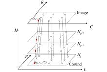
The RFM model for optical satellite remote sensing images is a major model for geometric processing of optical satellite remote sensing images, and its adjustment method has always been a focus of satellite photogrammetry research
Oct. 30, 2024Vol. 45 Issue 5 43 (2024)
Zhiwei ZHAO... and Shuwen YANG|Show fewer author(s)
In order to further reduce the spectral and spatial distortion of the fused images from multispectral and panchromatic images, and improve the fusion quality, this paper proposes a particle swarm optimization pulse coupled neural
Oct. 30, 2024Vol. 45 Issue 5 51 (2024)

Xiangyang KONG... and Baogen XU|Show fewer author(s)
Due to factors such as uneven pixel response of the detector, mechanical motion of the sensor, and temperature changes during image acquisition, hyperspectral images often contain stripe noise. Current destriping methods often foc
Oct. 30, 2024Vol. 45 Issue 5 64 (2024)
Shuwei CUI, and Wenbo WU
Infrared target detection faces challenges such as limited effective pixels, low SNR, and difficulty in distinguishing targets from background and noise in the spatial domain. In response, we propose a infrared target detection me
Oct. 30, 2024Vol. 45 Issue 5 79 (2024)
Pan SHAO... and Weichao SHI|Show fewer author(s)
Currently, remote sensing image change detection methods based on deep learning are still not effective enough to be satisfactory when dealing with images with significant scale changes, and most of the methods lack effective inte
Oct. 30, 2024Vol. 45 Issue 5 89 (2024)
Lijuan ZHANG... and Lingfeng YIN|Show fewer author(s)
Evapotranspiration is a key component of the global water cycle and significantly impacts water cycling and energy balance. However, existing evapotranspiration data exhibit limitations in their spatial and temporal resolution. To
Oct. 30, 2024Vol. 45 Issue 5 101 (2024)
Zongqi LIU... and Limin ZHAO|Show fewer author(s)
In addressing the prevalent issue of terrain occlusion in satellite oblique images, this paper proposes a high-resolution occlusion detection method based on the Rational Polynomial Coefficients (RPC) model. The proposed approach
Oct. 30, 2024Vol. 45 Issue 5 112 (2024)
Yaping WANG... and Jun LIU|Show fewer author(s)
In the face of the problem that the accuracy of cyanobacteria bloom area in lakes estimated with low and medium resolution images is poor due to the low monitoring scale, this paper took GOCI-2 as an example, selected the Taihu La
Oct. 30, 2024Vol. 45 Issue 5 123 (2024)
Guanbing HU... and Kun YANG|Show fewer author(s)
In order to analyze and evaluate the application ability of multi-spectral and hyper-spectral data of ZY-1 02E satellite in vegetation ecological investigation in plateau area, this paper chooses Huize-Dongchuan in northeast Yunna
Oct. 30, 2024Vol. 45 Issue 5 134 (2024)
Wenzhuo WANG... and Lei WU|Show fewer author(s)
Aiming at the problem of insufficient accuracy and timeliness of wildfire monitoring, a near real-time fire monitoring algorithm using a Multichannel Convolutional Neural Network (MCNN) with a cascaded traditional method is propos
Oct. 30, 2024Vol. 45 Issue 5 147 (2024)
© Copyright 2018-2021 | Chinese Laser Press.
All Rights Reserved 沪ICP备15018463号-20