


 View fulltext

2024
Volume: 45 Issue 3
14 Article(s)

Yaoxin ZHANG... and Jingbo ZHANG|Show fewer author(s)
Artificial intelligence (AI) technology has been gradually developed and matured since its birth in 1950s. It has been widely used in different fields of society, and the major space agencies have gradually applied it into the spa
Jul. 31, 2024Vol. 45 Issue 3 1 (2024)
Jiafu ZHANG... and Renyuan WANG|Show fewer author(s)
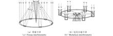
Optical synthetic aperture technology is an effective way to increase the effective aperture of telescopes, enhance their resolutions, and improve their light-gathering capabilities. However, the technical difficulty of large-aper
Jul. 31, 2024Vol. 45 Issue 3 7 (2024)
Weiming TONG... and Minlong LIAN|Show fewer author(s)
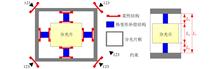
Mounting large radius-to-thickness ratio beamsplitters for cryogenic space application requires a careful trade-off in stiffness and flexibility design. Both the cryogenic wavefront error and the survivability in launch vibration
Jul. 31, 2024Vol. 45 Issue 3 19 (2024)
Yuan LUO... and Chaoqun XIA|Show fewer author(s)
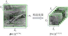
The existing infrared small target detection technologies have some shortcomings in terms of target detection capability, background suppression capability, and real-time performance, which fails to meet practical needs. Tensor an
Jul. 31, 2024Vol. 45 Issue 3 28 (2024)
Wenfei TAI... and Xuewei SHI|Show fewer author(s)
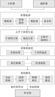
Synthetic aperture radar (SAR) image is not widely used in the field of change detection due to coherent spot noise, imaging geometric distortion, and the complexity of background information. This paper summarizes the current com
Jul. 31, 2024Vol. 45 Issue 3 41 (2024)
Yongle GAO... and Tao WANG|Show fewer author(s)
In the past decades, spatio-temporal fusion technology has provided an economical and efficient method to realize long-time series observation, but this method has a weak ability to retain structural information and low computatio
Jul. 31, 2024Vol. 45 Issue 3 51 (2024)

Jin MA... and Wuming ZHANG|Show fewer author(s)
Accurate and efficient point cloud branch and foliage separation are essential for accurately calculating above-ground biomass and carbon stocks. However, current methods are computationally expensive and rely on priori knowledge
Jul. 31, 2024Vol. 45 Issue 3 62 (2024)
Jia TIAN
In the study area of the forest-grass ecotone in Weichang County, Hebei Province, spectral reflectance data of non-photosynthetic vegetation (NPV), bare soil (BS), and photosynthetic vegetation (PV) were utilized from spectral lib
Jul. 31, 2024Vol. 45 Issue 3 73 (2024)
Sijun DONG, and Xiaoliang MENG
With the rapid development of remote sensing technology, high-precision remote sensing image feature extraction has become increasingly crucial in fields such as geographic information science, urban planning, and environmental mo
Jul. 31, 2024Vol. 45 Issue 3 82 (2024)
Yuting XIE... and Yuang LI|Show fewer author(s)
Aiming at the problems of insufficient attention to detailed information such as small water bodies and water edges in remote sensing image water body extraction research, as well as poor water body connectivity, this paper propos
Jul. 31, 2024Vol. 45 Issue 3 92 (2024)
Zengyou WANG... and Wanghuang ZHU|Show fewer author(s)
Aiming at the problem that feature information is easily lost and lacks attention to target features when the LinkNet network model performs road image segmentation tasks, a high resolution remote sensing image road extraction met
Jul. 31, 2024Vol. 45 Issue 3 107 (2024)
Linhai YU... and Bing HAN|Show fewer author(s)
Aiming at the problem of low accuracy of traditional classification methods in identifying citrus planting spatial information, this paper proposes a county-level citrus planting spatial information extraction method combining mul
Jul. 31, 2024Vol. 45 Issue 3 118 (2024)
Jinghao ZHANG... and Yongchao ZHENG|Show fewer author(s)
Ocean Lidar has the technical characteristics of strong water penetration, high vertical resolution and all-day observation, so it has great application potential in satellite ocean profile measurement. But the accurate measuremen
Jul. 31, 2024Vol. 45 Issue 3 131 (2024)
Xinwei YANG... and Kaimin WANG|Show fewer author(s)
Forest canopy closure is an important factor in describing forest structure. The traditional remote sensing inversion empirical model of canopy closure has high requirements for ground sample data and has the problem of difficulty
Jul. 31, 2024Vol. 45 Issue 3 137 (2024)
© Copyright 2018-2021 | Chinese Laser Press.
All Rights Reserved 沪ICP备15018463号-20