


Please enter the answer below before you can view the full text.
9+6=
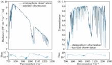
In order to accurately obtain land surface temperature (LST) from stratospheric platform, a simulation data set was established based on the SeeBor atmospheric profile training dataset and MODIS split window channel parameters. Firstly, the effectiveness of the general split window algorithm obtaining surface temperature at stratospheric altitude was analyzed; then, the sensitivities of several key parameters such as observation height, emissivity, water vapor content, noise equivalent temperature difference (NETD), and spectral response drift were analyzed. The LST simulation shows a theoretical error of 0.185 K, in which the emissivity and NETD dominate inversion error. Finally, the deviation constraint demand of different influencing factors is analyzed. Results show that if the uncertainty of emissivity and NETD can be controlled within 1% and 0.4 K, respectively, with spectral response drift within ±3 nm, the temperature inversion accuracy can be better than 2 K.
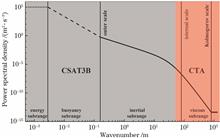
The wind speed fluctuation data with a sampling frequency of 4000 Hz are obtained by using a single-channel constant temperature hot-wire anemometer, and the complete wind speed fluctuation power spectrum including energy range, inertia subrange, and dissipation range is obtained. Based on the power spectrum analysis, the variation rules of the internal scale and energy dissipation rate of near-surface atmospheric wind speed turbulence with time are obtained, and the relationships among the turbulent internal scale, turbulent energy dissipation rate, and atmospheric stability are analyzed. These results are compared with the measured results of three-dimensional ultrasonic anemometer. The results show that the near-surface turbulent energy dissipation rate ranges from 10 -4 m 2/s 3 to 10 -1 m 2/s 3, and the internal scale ranges from 10 -3 m to 10 -2 m. When the atmosphere is stable, the average turbulent energy dissipation rate is 0.0146 m 2/s 3, and the average internal scale is 0.0089 m. When the atmosphere is unstable, the average energy dissipation rate is 0.0592 m 2/s 3, and the average internal scale is 0.0077 m. Because the power spectrum analysis method directly measures the internal scale of turbulence, the calculated internal scale is the most accurate.
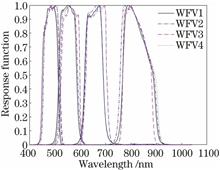
This paper proposes a time-series calibration method based on Kalman filtering to monitor the changes in the on-orbit radiometric performance of satellite sensors, increase the frequency and accuracy of calibration, and meet the application requirements of quantitative remote sensing in the new era. Taking the Dunhuang radiation calibration field as the test field, we obtain the multi-scene images of the GF1 wide field of view (GF1-WFV) sensor in the sites of Dunhuang from 2013 to 2020. First, the gray values of the images are normalized, and the standard deviation is used to eliminate outliers; thus, valid images are filtered out. Then, the time-series calibration method based on stable targets with historical data is employed to calculate the calibration coefficients, and the idea of Kalman filtering is applied to further process the calibration coefficients. Finally, the calibration results in this paper are compared with the calibration results of the China Centre for Resources Satellite Data and Application (CCRS) and Landsat8 calibration results separately. The results reveal that the maximum annual attenuation rate of the GF1 sensor during the on-orbit operation period does not exceed 0.3%, which indicates that the sensor has not significantly attenuated. Through the comparison and verification of the calibration results, we find that the calibration results obtained by the time-series calibration method based on Kalman filtering are more accurate than those of CCRS, and the maximum reduction in the average relative error of each band is 16.14%. This demonstrates that the time-series calibration method based on Kalman filtering has good reliability and stability.
In the marine area, the all-weather atmospheric optical turbulence profile within the boundary layer is obtained by inversion by coherent Doppler laser wind profile radar. The machine learning approach and back propagation neural network is used to train the optical turbulence estimation model of the boundary layer. The conventional meteorological parameters measured by sounding are used as model input parameters to estimate the atmospheric optical turbulence profile in the boundary layer on different days and different times, and compared with the measured values. The error analysis shows that the root mean square errors of the estimated optical turbulence profiles at day and night are 0.4332 and 0.5626, respectively, and the correlation coefficients are 0.8899 and 0.7673, respectively. The research proves that the optical turbulence profile inversion of coherent Doppler laser wind profile radar can realize the function of all-weather estimation of optical turbulence profile of the oceanic atmospheric boundary layer through the neural network model, and the effect is good. It has great engineering reference significance in photoelectric engineering and astronomical site selection.
A dual-wavelength Raman-Mie lidar technique and system are proposed in this paper to provide sufficient aerosol information for the solution of the radiative transfer equation. First, a high-performance four-channel spectroscopic system is designed to extract the Mie-Rayleigh scattering echo signals with center wavelengths of 354.7 nm and 1064.2 nm and Raman scattering echo signals of 386.7 nm and 852.7 nm for the fine detection and inversion of atmospheric aerosols. Then, the system is applied for experiments under different weather conditions, and the list of actual atmospheric aerosol state parameters is formed on the basis of the aerosol multi-parameter profiles obtained by inversion, which is composed of 33-layer optical thickness, single scattering albedo, and scattering phase functions. The list is used as the input file of actual atmospheric aerosols for the Santa Barbara DISORT atmospheric radiative transfer (SBDART) model. Finally, the radiative transfer equation is solved, and the calculation results of the actual atmospheric scattered radiance distribution of 33-layer and the direct and diffuse solar irradiance are obtained. By analyzing the actual atmospheric scattered radiance under different weather conditions, this study verifies the decisive influence of the atmospheric aerosol on atmospheric scattered radiance. The experimental results reveal that the average relative error of the total irradiance measured by the system and the ground meteorological station is 8.2%, and the correlation coefficient reaches 0.98.
The mirror reflection of sunlight by the sea surface forms flares. However, conventional detection imaging is prone to be saturated due to their high light intensity, which seriously affects the detection of sea-surface targets. Depending on the polarization characteristics of sea surface flares and the integral characteristics of a time-delay-integration complementary metal oxide semiconductor (TDI-CMOS) in the digital domain, this paper designs and constructs an adaptive polarization detection system for sea-surface targets. With the help of this system, the polarization characteristics of sea-surface targets can be obtained by imaging them with a polarization camera in real time. The system guides the TDI-CMOS camera in the digital domain to suppress flares in time and space domains. In this paper, an experimental platform is built for water surface observation, and relevant validation experiments are carried out for typical targets. The experimental results show that the detection system can effectively suppress the influence of solar flares on images. Compared with ordinary images, the obtained flare suppression images have a significantly enhanced signal-to-clutter ratio, which effectively improves the artifacts caused by moving targets on images and greatly facilitates the detection of sea-surface targets.
High-precision centroid positioning is the key to the geometric calibration method based on a single collimator and a separated two-dimensional turntable. However, the relative response difference of the instrument will affect the centroid positioning accuracy. Therefore, a centroid positioning accuracy improvement method based on the relative response correction is proposed, which can effectively improve the centroid positioning accuracy, thereby improving the geometric calibration accuracy. The laboratory geometric calibration experiment based on the directional polarimetric camera proves the improvement effect of the proposed method. The improvement effect is more significant in the large field of view area, and the maximum geometric calibration accuracy is about 0.1 pixel. Finally, based on the proposed centroid positioning accuracy improvement method, the geometric model parameters of high-precision directional polarimetric camera are obtained in the laboratory, and the model fitting residual is better than 0.1 pixel.
Using optical imaging equipment for survey of underwater resources often obtains lower quality of image because of underwater bubble’s interference. Taking analysis of radiation transmission characteristics of bubble and interference characteristics on the optical imaging instrument in the water environment has important guiding significance for improving anti-jamming capability of underwater imaging. At first, the single bubble underwater imaging environment is built and the changing trends of radiation intensity and polarization state for light transmitting in single bubble are simulated, and the transmission phase function on the interface of single bubble is obtained. Then, the changing trends of radiation intensity and polarization state of light with bubble distribution under multi-bubble imaging environment are simulated when increasing the number of bubbles on the basis of research on single bubble. Finally, the effects on forward transmission and backward transmission characteristics with different radius of bubble sizes and different distances of light transmission are simulated with Monte Carlo method based on theory of geometrical optics approximation. The study of bubble theory, simulation and experiment shows that the changing trend of produced light’s polarization at surface of bubble has strong correlation with observation geometry, when the angle of incidence is small, light has strong penetrability and the attenuation of radiation intensity is slow. The degrees of polarization of forward transmission and backward transmission show significantly opposite trend with increase of transmission distance. The theory, simulation and experimental results are basically consistent. The research can provide a certain reference value in target polarization imaging field under complex underwater environment.
For the applications of efficient high-precision object detection in optical remote sensing (RS) images, this paper focuses on the difficulty of improving the detection accuracy of the SSD (single shot multibox detector) model on small and densely distributed objects in such images. An improved model FFC-SSD (multi-scale feature fusion & clustering SSD) is thereby proposed. For this purpose, a bounding-box group clustering (BGC) module is designed. Group clustering is implemented to obtain default object frame parameters that are more consistent with the size distribution of object samples and gives more attention to small objects. This module effectively improves the network’s ability to extract object locations. Then, an efficient de-pooling multi-scale feature fusion (MSFF) module is designed to enhance the ability of the model to extract object features and effectively reduce the efficiency loss of the model at the same time. The experimental results demonstrate the effectiveness and applicability of the FFC-SSD model for object detection in optical remote sensing images. The proposed model achieves a favorable balance between precision and efficiency and has high detection accuracy on small objects.
On orbit radiometric calibration based on blackbody is one of the radiometric calibration schemes used in the infrared channel of the Advanced Geosynchronous Radiation Imager (AGRI). Some of the images from long wave infrared channels of AGRI still have some band noise after blackbody calibration, which will affect the image quality. In this paper, the radiometric calibration model of AGRI based on spaceborne blackbody is analyzed, and the concept of spectral response non-uniformity between pixels in the channel is proposed; then, the relationship between the non-uniformity of the spectral response between pixels and the band noise is simulated and analyzed. Finally, based on the analysis results, a method of relative radiometric calibration using a uniform scene is proposed, and the imaging data of AGRI are used to verify the effectiveness of this method to suppress the stripe noise caused by the non-uniformity of spectral response between pixels.
In order to meet the alignment requirements of the primary and secondary mirrors of the Chinese giant solar telescope (CGST), an active alignment method of laser truss based on laser interferometry is proposed. First, the optical structure and measurement principle of the CGST laser truss measurement system are introduced, then the laser truss kinematics model and active alignment optical model are established, and the error propagation characteristics of the system are discussed. Then, the effects of temperature field and local atmospheric turbulence on the active alignment method are discussed through the atmospheric optical model. The results of motion analysis and optical modeling show that in the visible band, when the ranging error of the laser truss is less than 5 μm and the environmental temperature gradient is less than 0.381 K/m, the wavefront root-mean-square caused by alignment error is better than λ/10. In addition, under the conditions of Kolmogorov turbulence and typical daytime near-surface turbulence, atmospheric turbulence does not seriously reduce the sensitivity of laser truss measurement. It can be seen that the proposed method can meet the requirements of active alignment of CGST secondary mirror.
With high precision and sensitivity, frequency scanning interferometry (FSI) absolute distance measurement technique is getting more and more attention in the field of large-scale equipment manufacturing. Building an optical fiber auxiliary interferometer in an FSI system to realize the precise monitoring of optical frequency changes is necessary for achieving higher ranging accuracy. However, the stability of optical path of the auxiliary interferometer is limited by the environmental factors and dispersion effect, which would reduce the accuracy seriously. An optical spectrum calibration based FSI absolute distance measurement method is proposed in this paper for this problem. The optical path of the auxiliary interferometer in the FSI system is calibrated in situ with the help of the absorption spectrum of hydrogen cyanide (HCN) to provide stable and accurate optical frequency reference. What’s more, a fast compensation method for dispersion mismatch error is proposed to eliminate the influence of dispersion mismatch effect caused by the fiber optic assisted interferometer on measurement results. The proposed method is verified by comparison experiments with commercial interferometer at a range of 20 m. The result shows that the largest ranging deviation of the system is less than 50 μm, and the repeatability is better than ±4 μm.
Bidirectional reflection distribution function (BRDF) in near infrared band can effectively characterize the reflection properties of materials and is widely used in computer modeling, remote sensing, aerospace, and other fields. In order to measure the BRDF value of near infrared band with high precision, a near infrared band BRDF measurement system is developed, and an absolute measurement scheme based on equal area luminance is proposed. The measurement system takes the center of the tested sample as the base point to re-model the spatial coordinate system of the measurement system, and uses the six-axis manipulator as the angle-changing device to realize the modeling, which can change the three-dimensional orientation of the sample without blind angles. The BRDF values of materials with any angle combination can be measured in 2π hemispheric space. The BRDF values of materials covering the near infrared band of 1000 nm to 3000 nm are measured with high precision. The system is used to measure the BRDF value of the standard diffuse reflection gold plate, and the results show that the relative uncertainty of the measurement result is 1.5%, indicating that the developed system has achieved high-precision measurement.
Aiming at the bottleneck of telephoto camera calibration, a novel calibration method based on conics and line fusion features is proposed. The article reveals the formation mechanism of ill-conditioned calibration equation of the telephoto camera. Given that the cross ratio and tangent point are basic projective invariants, a concentric semi-circular template is designed. Combined with the normalized line homography estimation method and the partitioned regularization estimation algorithm, the high-precision solution of initial values of intrinsic and extrinsic parameters of the telephoto camera is obtained. Further, considering the lens distortion, the integral distance between line segments is introduced, taking the minimum distance from the model line to the projection plane as the cost function, and a nonlinear optimization algorithm is adopted to refine the calibration parameters. Simulation and actual experimental results show that the proposed calibration method of the telephoto camera is effective, and has higher accuracy and robustness compared with the traditional method.
In this paper, a refraction and diffraction mixed compensation test optical path based on computer-generated hologram (CGH) has been proposed, and the combination of the CGH and aplanatic lens is realized to measure the off-axis segment in null test with focal reducing. The total length has been reduced to 1/4 to 1/8 of that of the conventional method. And the adjustment sensitivity of the small focus ratio segment has been improved. The distortion ratio of the interferogram of the large off-axis segment has been optimized from 12.5 to 1.25. The segments with different off-axis distances can be measured rapidly with high precision by replacing different computer-generated holograms and keeping every elements in place. The method is used to complete the processing and testing of a Φ330 mm off-axis trial mirror, and the root mean square (RMS) value of the test surface figure is 0.0290λ (λ is wavelength). The RMS value of the test surface figure is reduced to 0.0267λ, by calibrating the aplanatic lens using a standard spherical mirror.
To solve the time-consuming and storage problems of the LiDAR point cloud deep learning network models in the deployment of embedded devices on the mobile terminal, a learnable binary quantization network model for LiDAR point clouds is proposed. The model refers to the idea of feature-based knowledge distillation and transfers the statistical feature knowledge of each layer of the full-precision network to the binary quantization network, which greatly improves quantification accuracy. A genetic-algorithm based learnable optimization algorithm for scale factor recovery of binary quantization is proposed, which searches for the initial optimal layer-wise scale recovery factor, and greatly reduces amount of network parameters through network self-learning. A statistical adaptive pooling loss minimization algorithm is proposed, including quantitative network self-adjustment and full-precision network transferring adjustment, which solves the problem of greater pooling information loss of quantitative networks. Experimental results show that the proposed algorithm achieves larger compression ratio and speedup ratio while obtaining high precision. Theoretically, it can compress PointNet by 23 times and accelerate it by 35 times at least or more, and also achieves good scalability for other mainstream point cloud deep networks.
The lack of calibration methods for the underwater light field camera restricts the applications of light field imaging technologies in underwater and other refractive scenes. Aiming at the above problem, the ray paths of the scene and those inside the camera in typical underwater scenes are modeled based on the multi-layer flat refractive model and the multi-projection-center model, and the corresponding underwater calibration parameters are estimated. The underwater calibration parameters of the light field camera are linearly initialized by using the flat refractive geometric constraints. Considering the internal ray path distortion in the real light field camera, the underwater calibration parameters are optimized nonlinearly by minimizing the reprojection error. Quantitative calibration experiments of simulated scenes and real underwater scenes are designed to verify the effectiveness of the proposed method. The results show that the proposed method can estimate the underwater calibration parameters accurately. In multiple real underwater scene experiments, the direction errors of the normal vectors of the refraction surfaces are all less than 0.8° and the distance errors of the refraction surfaces are all less than 3%. The quantitative comparison experimental results show that, compared with the single-view underwater calibration method, the proposed method makes use of the multi-view characteristics of the light field camera, so the calibration results are closer to the real values.
Algal photosynthesis inhibition method is a potential method for rapid detection and early warning of comprehensive toxicity of water, and stable test conditions are critical to the toxicity test results of the algae photosynthetic inhibition method. In this paper, Chlorella pyrenoidosa is used as the test algae, and according to the characteristic that pesticide Dailon (DCMU) has an inhibitory effect on the photosynthetic activity of algae, the inhibition rates of the four photosynthetic fluorescence parameters (α, Fv/Fm, Yield, and rP) are as the analysis objects. Under the stress of different mass concentrations of DCMU, the influences of the three test conditions, including the mass concentration of the tested algae, the mixed volume ratio of the algae liquid to the sample, and the reaction temperature, on the stability of detecting the comprehensive toxicity of water has been studied separately. The results show that when the mass concentration of the tested algae is in the range of 100~600 μg·L -1, the change of the algae mass concentration has no significant impact on the detection of comprehensive toxicity of water. However, the mixed volume ratio of the tested algae solution to the water sample has a great impact on the sensitivity of toxicity detection. When the mixed volume ratio of the tested algae solution to the water sample is 2∶8, it is more conducive to improving the sensitivity of aquatic toxicity detection. In addition, the reaction temperature also has an important effect on the detection of comprehensive toxicity of water, and when the temperature is between 20 ℃ and 35 ℃, it is more conducive to improving the detection accuracy of comprehensive toxicity of water.
In order to study the influence of different mixing methods of black carbon and non-absorbent aerosol on quantum channel parameters, according to the extinction coefficient of black carbon and sulfate and organic carbon aerosols under the mixed models of Core-shell and Maxwell-Garnett, the channel attenuation model is established and simulated, and the data relationship between black carbon volume fraction/channel correlation factor in mixed aerosol particles and double Pauli channel/associated bit flip channel parameters is studied. The influence of black carbon volume fraction and quantum signal transmission distance on the key security transmission rate is analyzed and the data simulation is carried out. The simulation results show that in the two mixed states, the attenuation of light quantum energy increases gradually with the increase of black carbon volume fraction, while the quantum security key generation rate decreases with the increase of black carbon volume fraction. Under different contents and models, the increase of channel correlation factor has a positive impact on the fidelity of channel teleportation, while the increase of the volume fraction of black carbon will weaken the fidelity of channel teleportation.
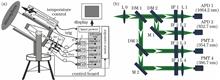
Aiming at the problem of slant visibility detection for safe take-off and landing of aircraft, a 4-channel Mie-Raman scattering scanning lidar is developed to achieve the dual-wavelength assumption-free retrieval of the atmospheric extinction coefficient profile, and then to finely obtain atmospheric slant visibility. Based on the atmospheric visibility theory, assuming that there is no light source near the observation path and ignoring the influence of aerosol particle spectrum distribution, the effectiveness of using atmospheric mean extinction coefficient to retrieve slant visibility is analyzed. This lidar utilizes the fundamental frequency (1064 nm) and triple frequency (355 nm) laser pulses of the Nd∶YAG laser as the light source, adopts the Raman polychromator with dichroic mirrors and narrow-band interference filters, and uses the finite state machine theory and multi-thread concurrency technique to realize the multi-module collaborative control software. Combined with the side-scattering visibility meter, the preliminary observation experiments and comparative analysis are carried out. The results show that when the weather is cloudy to overcast, the ground horizontal visibility is 9 km and the pitch angle is 26°, the effective detection distance of this system within 4 min cumulative time is better than 11 km, and the near-ground analysis results are in good agreement.
Based on the clustering idea, two-dimensional and three-dimensional cloud phase clustering identification algorithms are designed. Combined with the data of polarization lidar, microwave radiometer, and millimeter wave radar, the fine identification and classification methods of cloud phase are studied. The volume depolarization ratio, temperature, and reflectivity factor of cloud particles are taken as the input characteristics of clustering network learning, and the cluster division results of distinguishing different cloud phase are obtained through unsupervised learning. The fine identification of cloud phase is realized by using the cluster division results, which solves the problem of misjudgment of results caused by the single threshold algorithm in traditional cloud phase identification. Using this algorithm, the supercooled water, warm cloud liquid water, and ice phase can be identified efficiently. At the same time, the ice and water dominated mixed phase can be classified in detail. The clouds over Xi’an are observed by the polarization lidar, microwave radiometer, and millimeter wave radar, and the synchronous observation data of three instruments are retrieved. The two-dimensional clustering algorithm and three-dimensional clustering algorithm are used to identify and analyze the cloud data observed from January 9 to 10, 2021 and June 8 to 9, 2021. The distinction of liquid water, mixed phase (ice dominated and water dominated), supercooled water, and ice phase in the cloud is realized. Through comparison and analysis, it is found that the three-dimensional clustering recognition algorithm can show more details of the phase transformation process than the two-dimensional clustering recognition algorithm. The overall identification results are consistent with the actual weather transformation process.
The conventional expectation maximum (EM) decomposition method combining threshold-based denoising and AIC (Akaike information criterion) is ineffective for eliminating the noisy completely. Moreover, the AIC is less flexible for a small sample target data. To solve this problem, an improved EM waveform decomposition method is proposed, which uses adaptive noise threshold estimation to eliminate background noise and random noise at one time. For the small samples and weak echo target data, the waveform decomposition is performed using EM algorithm collaborated with AICC (Akaike information criterion, corrected). The effectiveness and accuracy of the proposed method are validated based on several sets of measured data.
Vertical stratification is one of the basic features of oceans, and almost all marine disciplines require direct or indirect profile information for measurement and analysis. LiDAR is the only remote sensing technology that can be used to obtain the profile information of oceans at a depth of over 100 m, and the echo signals of LiDAR are mainly affected by the joint absorption and scattering effect of water molecules and particulate matter in oceans. When the backscattered signals of LiDAR at 180° are used for the inversion of the components of the particulate matter in oceans, the complexity of water optical properties is determined by the complexity of particulate matter in aspects such as grain size, components, shapes, and internal structure. The particulate matter includes living phytoplankton and their degradation products, inorganic particles (suspended sediment), zooplankton, and air bubbles. The volume scattering coefficient β(π) at 180° is the basic parameter for the water body detection of LiDAR, and the scattering phase functions of different phytoplankton particles differ by a factor of 10 at 180°. In LiDAR simulations and calculations, researchers use the general-purposed volume scattering functions measured by Petzold and the polarization parameter of the Mueller matrix measured by Voss & Fry, which may cause significant divergence compared with specific in-situ results. Given this basic and paramount problem in LiDAR and also in active and passive optical ocean observing and detection, this paper gives a review in this regard. Moreover, the major theoretical and technological problems to be solved are put forward by referring to the relevant research results in recent years.
As a new type of active earth observation technology, hyperspectral LiDAR combines the advantages of three-dimensional spatial information acquisition of traditional LiDAR and imaging technology of passive hyperspectral sensors. Hyperspectral LiDAR can realize the integrated imaging detection of high spatial resolution and hyperspectral resolution, which has become an important direction of the development of remote sensing technology in the future. First, the development process and unique advantages of hyperspectral LiDAR imaging technology are discussed from the research progress of spatial-spectral integrated data acquisition technology for LiDAR. Then, in terms of the application and development of the airborne platform, the technological development of laser transmitting unit, receiving and detecting unit, and data processing unit is introduced from the key technical difficulties in the development of airborne hyperspectral LiDAR system. Finally, in view of the future development prospects, the major application potential of airborne hyperspectral LiDAR in land cover classification, vegetation remote sensing monitoring, marine resource detection and military target detection is analyzed. Meanwhile, the future promotion and application of this technology are prospected and analyzed. Due to its advantages in spatial-spectral integrated data acquisition, airborne hyperspectral LiDAR is expected to develop into a new type of remote sensing technology in the future.
Throughout the review of several typical space-borne low-light remote sensing devices onboard the domestic and international satellites, this paper introduces the design principle and components of the Medium Resolution Spectral Imager-Low Light (MERSI-LL) onboard FY-3E. It describes the special three gain combination design of MERSI-LL low-light band (LLB) for the characteristic of large dynamic range of radiance signals on the twilight orbit. The working principle of the MERSI-LL onboard calibrator based on solar diffusing/transmission board is described in detail. In this paper, the selection of three gain channels and normalized fusion processing methods are given, and processing procedures of low-light channel data are introduced. The paper summarizes the several calibration methods for LLB including on-board calibration, vicarious calibration, ground-based artificial light source calibration, and cross calibration. The quantitative scientific product retrieval capability of MERSI-LL is briefly summarized, and the near-constant contrast (NCC) image products generated based on MERSI-LL observation data are displayed. The generation process of typical nighttime light products from LLB is mainly described. Examples of its products and potential applications are given. Finally, based on the lessons of data processing and product generation of Early morning Satellite MERSI-LL LLB, the future improvement ideas and application perspectives of the instrument are discussed.
Solar radiation in the visible domain can penetrate aquatic environment, which drives photon-related processes including phytoplankton photosynthesis and heating of the upper water column. In addition, the scattered light in the water column can emerge (escape) from water, which forms the bases to sense properties in aquatic environments using sensors onboard satellites. Thus, an understanding of the processes and properties related to the propagation of solar radiation in-and-out of water is a basic requirement in ocean optics and ocean color remote sensing. The spatial (and spectral for inelastic scattering) variation of radiance is governed by the radiative transfer equation, which is not directly applicable to infer in-water optical properties or to describe the relationships between the optical properties measured in the field and inherent optical properties related to environmental properties. Through simple mathematical derivations, or manipulations, of the radiative transfer equation (RTE), ?as transferred the RTE into a set of two equations describing the change of upwelling and downwelling irradiance with depth, and further obtained concise analytical relationships between the apparent and inherent optical properties. These equations not only form the basic theoretical relationships in ocean optics, but also lay the foundation of semi-analytical algorithms in ocean color remote sensing.
To study the mechanism of stimulated Brillouin scattering (SBS) excited by high energy laser in water, a structure model of a non-uniform refractive index grating based on nonlinear polarization and nonlinear absorption of high intensity laser is proposed, and the physical mechanism and spectral characteristics of SBS in water are analyzed. The mechanism of the non-uniform refractive index grating generated by SBS effect in water is studied by establishing the modulation structure and periodic structure of the non-uniform refractive index grating. The effect of the structure of the non-uniform refractive index grating on the spectral characteristics of SBS, such as linewidth, frequency shift, and diffraction efficiency, is analyzed by using the transfer matrix method. Also, the theoretical simulation results are compared with the experimental results. The results indicate that the theoretical simulation results are in good agreement with the experimental results, and the physical mechanism of SBS in water can be analyzed effectively by using the structure model of the non-uniform refractive index grating.
The frequent occurrence of brown tide pollution in recent years has brought huge losses to the economy of coastal areas. Therefore, the accurate and efficient identification of brown tide algae is of great significance to the prevention of marine environmental pollution. In this paper, a combination method of three-dimensional fluorescence spectroscopy, gradient boosting decision tree (GBDT), and logistic regression (LR) is used to achieve accurate identification of brown tide algae. In order to solve the problem of weak feature combination ability of LR model for nonlinear data, the GBDT algorithm is introduced to make full use of the advantages of the integrated learning algorithm in processing nonlinear data. The prediction result of GBDT model is used as a new feature instead of the original feature which is input into the LR model, and a brown tide algae recognition model (GBDT-LR)that combines GBDT and LR is established. In response to the interference of other types of algae in the complex marine environment, five different types of algae such as Chlorella and Synechococcus elongatus are introduced for comparison in the experiment, and analyzed the identification of brown tide algae in different growth cycles are analyzed. The proposed model is compared with LR, support vector machine (SVM) and back propagation (BP) neural network under the same conditions. The results show that the GBDT-LR model is superior to the other models in terms of classification accuracy, recall rate, and F1-score. The fluorescence spectrum of algae in the exponential growth period is the most stable, and the identification result of the brown tide algae in this period is the best.