


 View fulltext

2024
Volume: 51 Issue 3
11 Article(s)

Jiangtao Han, Kai Tan, Weiguo Zhang, Ruotong Zhou, and Shuai Liu
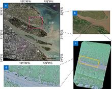
Spatial self-organization is a common phenomenon in many natural ecosystems. The "fairy circle" is a typical spatial self-organization structure that has significant impacts on the ecological functions of the salt marsh vegetation ecosystems. Obtaining the spatial pattern and spatiotemporal changes of the "fairy circle" can provide important scientific support for clarifying its ecological evolution mechanism. In this study, a machine learning method based on random forest is used to intelligently identify and extract the "fairy circle" in salt marsh vegetation using the spatial-spectral information from unmanned aerial vehicle (UAV) LiDAR. First, the effects of the distance, incident angle, and specular reflection on intensity data are eliminated using the laser radar equation and the Phong model. Second, the corrected intensity data are filtered to separate the vegetation from the ground. Third, a series of spatial features and geometric variables are used to classify the normal vegetation and "fairy circles" using the random forest algorithm. The results demonstrate that the proposed method can accurately extract "fairy circles" from UAV LiDAR 3D point cloud data without requiring manual experience-based parameter settings. The overall accuracy of the proposed method is 83.9%, providing a high-precision method for the spatiotemporal distribution inversion of "fairy circles" and technical references for 3D point cloud data processing based on machine learning.
Apr. 05, 2024Vol. 51 Issue 3 230188-1 (2024)
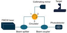
Huiyu Qi, Weihua Zhang, Didi Zhai, Xinyi Zhu, and Zhaohui Li
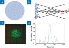
We demonstrate a new laser detection and ranging (LiDAR) system for reconstructing remote targets in three dimensions (3D). In this system, a probe beam, of which wavelength is 532 nm, working at Bessel mode rather than Gaussian mode, exhibits a typical intensity distribution of a bright central spot and some surrounding rings, and takes advantage of non-diffraction character in long-distance ranging. It is an attractive way to improve the imaging resolution of the LiDAR system. Combined with the Si-APD, we built a long-distance LiDAR system and completed the verification experiment. The results indicate that we can achieve an 18.1-μrad angle resolution in long-range target imaging, which provides an effective solution for high-resolution remote imaging.
Apr. 05, 2024Vol. 51 Issue 3 230243-1 (2024)
Anran Li, Guangcun Shao, Fengyu Jin, Chuanhui Zhang, Wei Li, Yuanhui Mou, and Enlin Cai
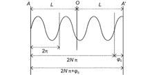
In modern science and technology, LiDAR plays a key role in automatic navigation, industrial mapping and other fields, but the traditional phase ranging system has many problems such as low measurement accuracy and complex structure. A new high-precision phase laser radar ranging system is proposed in this paper. The system adopts the phase difference detection method of laser control with the same frequency reference, including the optical structure optimization of the laser transmitting and receiving modules, and the amplification filtering and differential mixing processing of the receiving circuit, and finally produces a high-resolution phase discrimination system based on AD8302. The experimental results show that the measurement accuracy of the system is millimeter level, which is simple and practical and can meet the needs of a wide range of practical applications. This research provides a feasible solution for LiDAR technology in high-precision distance measurement.
Apr. 05, 2024Vol. 51 Issue 3 230246-1 (2024)
Shenbo Hu, Junchen Liu, Su Yu, Chengyu Yang, Xinghua Qu, and Fumin Zhang
For large complex electromechanical systems such as aeronautics and astronautics, the demand for length measurement has also evolved from one-dimensional displacement measurement to multi-objective, flexible and extensible multiline parallel measurement. The frequency-modulated continuous-wave lidar length measurement technology has the advantages of anti-interference, high precision and no cooperation. In this paper, a multiline parallel coherent precision length measurement method based on frequency modulation continuous wave laser lidar is studied. To solve the problem of fiber dispersion and auxiliary fiber drift in the traditional length measurement system, a three-channel Mach-Zehnder interferometry system containing a hydrogen cyanide gas absorption cell is proposed. On this basis, the precision length multiline parallel measurement is realized based on the optical switch structure. The experimental results of precision guide rail length measurement show that the proposed method is less than 25 μm in the length range of 3.6 m. The four-way parallel length measurement is realized. The absolute error of the multi-channel measurement results is not more than 30 μm compared with the measurement results of a commercial laser interferometer.
Apr. 05, 2024Vol. 51 Issue 3 230285-1 (2024)
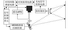
Suisui Wan, Yajun Pang, Ruixiang Xue, and Zhenxu Bai
To address the ineffective reception of larger scanning field echoes by the small photosensitive area of the indium gallium arsenide InGaAs detector in the 1550 nm wavelength band, a receiver device suitable for near-range wide field-of-view applications has been designed. The optical system at the receiving end utilizes an afocal telecentric structure as the receiving antenna, achieving a reception field-of-view of 36° at a photosensitive area of 1 mm. The relative illuminance exceeds 95%, demonstrating excellent light collection and transmission characteristics. Additionally, the receiver circuit adopts a T-network amplification structure combined with a moment identification circuit, utilizing the TDC7200 to achieve high-precision time measurements. The flight time measurement accuracy is less than 120 ps within a range of 200 ns, and the experimental results demonstrate ranging accuracy better than 2 ns within an 8 m distance, meeting the requirements for near-range detection.
Apr. 05, 2024Vol. 51 Issue 3 230287-1 (2024)
Huaiyu Cai, Zhaoqian Yang, Ziyang Cui, Yi Wang, and Xiaodong Chen
Abandoned objects on the road significantly impact traffic safety. To address issues such as missed detections, false alarms, and localization difficulties encountered in detecting of small-to-medium-sized abandoned objects, this paper proposes a method for detecting and locating abandoned objects on the road using image guidance and point cloud spatial constraints. The method employs an improved YOLOv7-OD network to process image data, extracting information about two-dimensional target bounding boxes. Subsequently, these bounding boxes are projected onto the coordinate system of the LiDAR sensor to get a pyramidal region of interest (ROI). Under the spatial constraints of the point cloud within the ROI, the detection and localization results of abandoned objects on the road in three-dimensional space are obtained through a combination of point cloud clustering and point cloud generation algorithms. The experimental results show that the improved YOLOv7-OD network achieves recall and average precision rates of 85.4% and 82.0%, respectively, for medium-sized objects, representing an improvement of 6.6% and 8.0% compared to the YOLOv7. The recall and average precision rates for small-sized objects are 66.8% and 57.3%, respectively, with an increase of 5.3%. Regarding localization, for targets located 30-40 m away from the detecting vehicle, the depth localization error is 0.19 m, and the angular localization error is 0.082°, enabling the detection and localization of multi-scale abandoned objects on the road.
Apr. 05, 2024Vol. 51 Issue 3 230317-1 (2024)

Yuanxin Guo, Kun Liang, Yangrui Xu, Yanpeng Zhao, Yuanqing Wang, and Bei Wang
LiDAR plays an important role in the remote sensing of environmental elements due to its active emission, high detection accuracy, good real-time performance, and high spatial and temporal resolution. Based on the coupling relationship between the scattering spectrum and the medium environment, the direct scattering spectrum LiDAR can invert the multiple environment elements by directly measuring the energy dimension and the spectral dimension multi-feature information such as energy, frequency shift, linewidth, etc. In this paper, the recent advances in spectrum characteristics research and spectrum detection techniques of direct scattering spectrum LiDAR are briefly summarized. The detection theory and inversion models of underwater and atmospheric direct scattering spectrum are mainly introduced, as well as the existing measurement methods of direct scattering spectrum.
Apr. 05, 2024Vol. 51 Issue 3 240003-1 (2024)
Chen Xu, Kai Jin, and Kai Wei
Synthetic aperture ladar is an advanced active optical imaging technology that overcomes the diffraction limit of the traditional optical system. This technology is inspired by the working principles of synthetic aperture radar in the microwave band. Compared with synthetic aperture radar, synthetic aperture ladar has several advantages such as fast imaging speed, high resolution, and its images being similar to what the eye is used to seeing, thanks to its operation wavelength, which makes synthetic aperture ladar potentially valuable. This paper aims to provide a comprehensive review of the progress made in key technologies related to synthetic aperture ladar, including its system model and basic theory, system design and structures, laser phase noise suppression technology, motion compensation technologies, and imaging algorithms. Furthermore, some important outdoor experiments at home and abroad were summarized. At last, the difficulties and challenges for the subsequent implementation of engineering were discussed.
Apr. 05, 2024Vol. 51 Issue 3 240007-1 (2024)
Ling Wang, Bo Liu, Cheng Wu, Lan Luo, and Yuqiang Yang
The optimization and design of optical systems is an important research direction in LiDAR. In this paper, the advantages of diffractive optical elements (DOE), such as high design degree of freedom and large dispersion, are used in the receiving end of LiDAR. The focusing and filtering effects are realized at the same time, which reduces the complexity of the optical system. Based on the principle of diffractive optical elements, the optical characteristics of diffractive optical elements are simulated and analyzed. The LiDAR ranging experiment is completed by using the diffractive optical element as the optical receiving end of the LiDAR. It proved that the diffractive optical elements have both a focusing effect and a narrow-band filtering effect. The experimental results are basically consistent with the simulation. Using the advantages of diffractive optical elements in LiDAR, the lightweight, integration, and high efficiency of LiDAR can be realized.
Apr. 05, 2024Vol. 51 Issue 3 240032-1 (2024)
Yuyang Zhao, Pengfei Zhou, Tianpeng Xie, Chenghao Jiang, Yan Jiang, Zhengwei Zhao, and Jingguo Zhu
With the rapid development of single-photon detectors and technologies, single-photon LiDAR with photon-level sensitivity has become a popular research topic. It plays an increasingly important role in fields such as remote sensing and mapping, intelligent driving, and consumer electronics. This paper focuses on LiDAR technologies and systems employing single-photon avalanche diode detectors, introducing three single-photon LiDAR detection principles: pulse accumulation, coding modulation and chirp modulation. Considering the importance of detectors and algorithms, it outlines the current development status of single-photon detectors and typical processing algorithms. It also reviews the applications and typical systems of single-photon LiDAR in long-distance detection, complex scene sensing, satellite/airborne remote sensing and mapping, intelligent driving navigation and obstacle avoidance, and 3D sensing in consumer electronics. Lastly, the paper analyzes the future development trends and forecasts the potential challenges of single-photon LiDAR technology in detectors, algorithms, systems, and application domains.
Apr. 05, 2024Vol. 51 Issue 3 240037-1 (2024)
Bo Liu, Bin Zhao, Yun Jiang, Songhua Wu, and Guang Wu
In recent years, the rapid development of LiDAR technology has played an increasingly important role in the field of scientific research and industry, giving new vitality to remote sensing, imaging, environmental perception and other fields. A special issue on "Innovation and application of LiDAR" was organized, which is around the single photon LiDAR, synthetic aperture LiDAR, FM continuous wave LiDAR, environmental factors LiDAR, imaging LiDAR, the new LiDAR precision measurement technology, as well as the recent main research progress. As a technical research reference and a exchange platform for scholars in related fields, this special issue will actively promote the research process of China's LiDAR technology.
Apr. 05, 2024Vol. 51 Issue 3 240076-1 (2024)
© Copyright 2018-2021 | Chinese Laser Press.
All Rights Reserved 沪ICP备15018463号-20