


 View fulltext
Journal of Atmospheric and Environmental Optics
Co-Editors-in-Chief
Wenqing Liu

2023
Volume: 18 Issue 4
9 Article(s)

LI Yingjie, GUAN Xin, WEN Yuan, ZHANG Miaomiao, GUI Lijia, and LI Yunduan
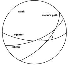
The hyperspectral observation satellite (Gaofen-5(02) satellite), successfully launched in September 2021, is an important indicator of hyperspectral remote sensing capability of China. The satellite has a high degree of quantification, with 6 out of 7 payloads having in-orbit calibration capability. In addition to the working modes of yaw 90° site calibration and yaw sun calibration, an attitude maneuver calibration mode to the moon has also been designed for the satellite. This paper mainly introduces the attitude maneuvering mode and lunar calibration scheme of hyperspectral observation satellites, elaborates on the law of lunar motion, the attitude maneuvering mode of maneuvering to lunar calibration, the observation window and angle of lunar calibration, and summarizes the workflow of lunar calibration, and analyzes the attitude pointing accuracy, illumination conditions, star-sensitive field of view and satellite thermal control of the lunar calibration. The analysis results show that in the process of maneuvering calibration to the moon, the platforms and payload systems can adapt well to the changes of the external environment such as illumination and external heat flux, and the pointing accuracy of the satellite can meet the observation requirements of lunar calibration.
Jul. 28, 2023Vol. 18 Issue 4 281 (2023)
ZHANG Miaomiao, WEN Yuan, ZHU Sifeng, XIE Yanqing, LI Yingjie, LI Yunduan, HONG Jin, LIU Zhenhai, LUO Donggen, SONG Maoxin, and WANG Yi
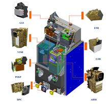
Hyperspectral observation satellite, launched on September 7, 2021, is an operational satellite planned in the "National Medium-and Long-Term Development Plan for Civil Space Infrastructure (2015-2025)", and is an important symbol of China's hyperspectral remote sensing capability. The satellite operates in a sun-synchronous orbit with an altitude of 705 km and a local time of dscending node of 10:30 AM. For the detection of fine particulate matters, the satellite is equipped with a dual-polarization crossfire payload suite composed of a high-precision particulate obersving scanning polarimeter (POSP) and an atmospheric multi-angle aerosol directional polarization camera (DPC), so aerosol information such as AOD and PM2.5 can be obtained through the joint detection of dual-polarization payloads. This paper mainly introduces the overall technical scheme of the hyperspectral satellite and the dual polarization payloads, and elaborates on the key design points of polarization crossfire mechnism, including the engineering design of timing, spectral channel selection, spectral channel matching and field of view matching. At the same time, the on-orbit performance of the polarization crossfire detection mode is evaluated. The results show that the time synchronization accuracy of the dual-polarization payload is better than 0.4 ms, and the field of view matching accuracy is better than 0.066 pixel of POSP, meeting the requirement of aerosol inversion. Finally, the in-orbit measurement performance of dual-polarization payloads is cross-verified. It is shown that the fitting determination coefficient of radiation measurement and reference value is higher than 0.96, and the average absolute difference of linear polarization is better than 0.0088, which meets the design requirements of in-orbit detection accuracy.
Jul. 28, 2023Vol. 18 Issue 4 295 (2023)
ZHU Sifeng, ZHU Mengyao, QIE Lili, XU Hua, LI Zhengqiang, XIE Yisong, HONG Jin, TU Bihai, and MENG Binghuan
In September 2021, China successfully launched the Gaofeng-5(02) satellite (GF-5(02)), which is equipped with a directional polarimetric camera (DPC) and a high-precision particulate observing scanning polarimeter (POSP), forming a "polarization crossfire" observation program. In order to evaluate the in-flight radiation performance of the DPC sensor loaded on GF-5(02) satellite, based on the DPC and POSP observation data in January 2022, two methods, ocean Rayleigh scattering and "polarization crossfire" cross-calibration between DPC and POSP, were used to achieve the absolute calibration in-flight and the relative radiometric consistency test in the field of view of DPC. The results show that compared with the laboratory calibration results before launch, the absolute radiometric and relative radiometric response of DPC/GF-5(02) after launch have not changed significantly, the absolute calibration coefficient of each band changes less than 5.3% after launch, and the change of relative radiometric response in the field of view is less than 2%. Specifically, the absolute calibration coefficients obtained by the two methods of Rayleigh scattering and cross calibration (DPC and POSP) at 443 nm band have a high consistency, with a deviation of about 2%, while the calibration results of the two methods at 490 nm and 670 nm bands have a large deviation, with a deviation of 7.4% and 7.7%, respectively. Overall, the radiation stability of DPC/GF-5(02) after orbit is better than that of DPC/GF-5.
Jul. 28, 2023Vol. 18 Issue 4 310 (2023)
DONG Jiantao, LI Zhengqiang, XIE Yisong, FAN Cheng, HONG Jin, DAI Liuxin, GU Haoran, and ZHENG Yang
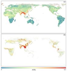
Atmospheric fine-mode aerosols, which are mostly originated from anthropogenic emissions, can reflect human activity's impacts on the atmosphere. Therefore, the fine-mode aerosol optical depth (AODf) is one of the basic parameters in the filed of atmospheric environment. Based on the remote sensing data of Directional Polarimetric Camera (DPC) onboard Gaofen-5(02) satellite, the AODf data over global land of spring 2022 (from March to May) were obtained using the look-up table retrieval method in this study, and then the AODf inversion results were verified using the ground-based observation of AERONET sites. Based on the analysis of AODf distribution, it is found that the distribution of global AODf shows an obvious north-south difference, with low values in the southern hemisphere and high values in the northern hemisphere mainly concentrated in the Asian region. In China, AODf distribution shows considerable differences between the two sides of the "Hu-Huanyong Line". On the south-east side, the high AODf values is mainly concentrated in the Sichuan-Chongqing region, North China Plain and the Guangdong-Guangxi region, while on the north-west side, AODf is generally low over Qinghai-Tibet Plateau and desert area. This kind of spatial distribution pattern of AODf reflects the influence from both anthropogenic factors and natural factors. As for South Asia and Central-North Africa, it is shown that AODf distribution is correlated with smoke and soot emissions from local burning combustion, and meteorological factors such as monsoon. In addition, the AODf retrieval data from DPC were compared with MODIS fine-mode aerosol products, and it is found that the spatial distribution of high AODf from the two datasets is basically consistent, while DPC data have a better coverage for bright surface than MODIS data, which makes it more suitable for providing data support for global and regional monitoring of atmospheric environment.
Jul. 28, 2023Vol. 18 Issue 4 323 (2023)
ZHAI Yingchao, WANG Han, ZHAO Meiru, CHEN Ke, and LI Linsen
The complex terrain characteristics of mountainous areas can increase the estimation error of surface reflectance, reduce the accuracy of land-atmospheric decoupling, and then affect the accuracy of aerosol retrieval. Currently, the widely used retrieval methods include the dark target algorithm (DT) based on the band relationship to estimate the surface reflectance, the deep blue algorithm (DB) based on the regional surface reflectance library, and the generalized retrieval of atmosphere and surface properties (GRASP) algorithm based on the bidirectional reflectance distribution function (BRDF) and bidirectional polarization distribution function (BPDF) model to estimate the surface reflectance. To explore the land-atmospheric decoupling methods suitable for aerosol remote sensing in mountainous areas of China, the accuracy and applicability of GRASP aerosol optical depth (AOD~~G) of polarization and directionality of the earth's reflectances (POLDER-3), DT aerosol optical depth (AOD~~DT) and DB aerosol optical depth (AOD~~DB) of moderate resolution imaging spectroradiometer (MODIS) in China from 2005 to 2013 were compared and analyzed using AErosol RObotic NETwork (AERONET) aerosol optical depth (AOD~~A). The results show that the overall correlation between AOD~~G and AOD~~A at non-mountainous sites is the highest (with correlation coefficient R = 0.921), and the overall accuracy of AOD~~DT and AOD~~DBis not much different. However, the proportion of AOD~~G higher than the expected error in mountainous areas is 79.87%, and the overestimation proportion of AOD~~DT and AOD~~DB increases by nearly 30% and 20%, respectively. Seasonal validation at two mountain sites, Xinglong in Hebei Province and Seimi-Arid Climate and Environment Observatory of Lanzhou University (SACOL), shows that the accuracy of all three satellite products tend to decrease in the autumn and winter seasons when the vegetation cover is low, indicating that the mountain topography can affect the accuracy of land-atmosphere decoupling after removing the influence of surface vegetation on reflectance. Further analysis shows that the mountainous terrain has a great influence on the land-atmosphere decoupling method based on BRDF and BPDF model.The multi-angle observation of surface band relationship is more conducive to accurate estimation of surface reflection over undulating surface such as mountainous areas, while there is no significant difference of estimating surface reflection between BRDF/BPDF models and band relationships in urban areas.The results provide a new direction for further optimizing the multi-angle observation (such as Gaofen-5 DPC) aerosol retrieval algorithm in mountainous areas.
Jul. 28, 2023Vol. 18 Issue 4 339 (2023)

GU Haoran, LI Zhengqiang, HOU Weizhen, QIU Zhenwei, LIU Zhenhai, ZHU Jun, QIE Lili, LUO Jie, HONG Jin, and MA Jinji
To explore the detection ability of the multiangle polarimetric remote sensing measurements in the ultraviolet band for aerosol layer height (ALH), the ALH retrieval information has been systematically evaluated under different observation conditions using the multiangle polarimetric measurements in ultraviolet bands. Based on the optimal estimation theory and the information content analysis method, the sensitivity of the ALH to the observations of 365 nm and 388 nm bands has been analyzed, and the impacts of different conditions on the information content and posterior error of ALH have also been assessed. The results show that: (1) The information content for ALH retrieval is significantly improved by adding multi-angle polarimetric measurements. (2) The information content increases significantly with the increase of the number of viewing angles, and the degree of freedom for signal (DFS) for ALH retrieval can be improved by more than 0.4. (3) Both the addition of polarization observation at 388 nm and the intensity observation at 365 nm can improve the DFS of ALH, however, compared to the intensity observation, the polarization observation shows better results and is less affected by the aerosol model error. Especially, the polarization observation can improve the ALH retrieval under low aerosol optical depth (AOD) conditions.
Jul. 28, 2023Vol. 18 Issue 4 357 (2023)
ZHANG Sugui, ZHANG Jingjing, XUN Lina, SUN Xiaobing, XIONG Wei, YAN Qing, and LI Sui
Cloud detection is of great significance for the application of remote sensing images. However, as for the existing cloud detection methods, there is limited research on the polarization information of remote sensing images, and their performance and generalization ability are also limited. To effectively utilize the polarization information of remote sensing images, a multimodal fusion remote sensing image cloud detection method based on depth learning is proposed and its preliminary experimental evaluation is conducted. In the method, the network is a three-parameter input stream architecture with an encoder-decoder structure, and the channel-spatial attention module is used to perfom multimodal fusion of reflectance and polarization features in remote sensing images. In the upsampling stage of the decoder, the iterative attention feature fusion method is used to fuse the high- and low-level feature maps. The evaluation experimental data set comes from Directional Polarization Camera (DPC) cloud products and cloud mask products. The evaluation results show that the proposed network model achieves good cloud detection performance, with a recognition accuracy of 93.91%.
Jul. 28, 2023Vol. 18 Issue 4 371 (2023)
GUO Tingwei, HUANG Honglian, SUN Xiaobing, LIU Xiao, and TI Rufang
In remote sensing images, large areas of thin clouds can obscure ground object information, which has a great impact on subsequent interpretation and application of the images. In order to eliminate the influence of thin clouds on the underlying surface in satellite images, an algorithm for thin cloud detection and removal in multispectral images is developed. In the algorithm, the blue-green bands is used to synthesize extrapolated bands firstly, and then cloud thickness map (HTM) and thin cloud mask map are generated through dark pixelsearch, thereby obtaining cloud-free area pixel and cloud area pixel. Secondly, the HTM of each band is calculated, then both of the HTM of the extrapolated band and the HTM of each band are used to obtain the linear regression coefficient of each band. Finally, the images are subjected to thin cloud removal based on the coefficients. The method is applied to the multispectral images of Huanjing Jianzai-2A/B (HJ-2A/B) satellites. The results show that for different surface types, the image quality is significantly improved after removing thin clouds, and the ground object information covered by thin clouds can be clearly displayed, without affecting the image quality of cloud-free areas at the same time. After using this algorithm to remove thin clouds, the clarity, contrast and standard deviation of the multispectral images can be significantly improved, which provides quality assurance for subsequent image applications.
Jul. 28, 2023Vol. 18 Issue 4 383 (2023)
© Copyright 2018-2021 | Chinese Laser Press.
All Rights Reserved 沪ICP备15018463号-20