


Please enter the answer below before you can view the full text.

2020
Volume: 75 Issue 2
15 Article(s)

Chuanglin FANG
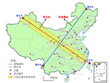
Promoting regional coordinated development strategy is one of the most important strategies in the new period of China. Faced with the reality of unbalanced and insufficient regional development in China, it is objectively necessary to construct one or more main axes supporting the coordinated and balanced development of regions to become the identification line representing the pattern of coordinated regional development. The results show that the Bo-Tai line, the northwest-southeast axis connecting Bole of Xinjiang and Taipei of Taiwan, can be built into a national development backbone line and regional balanced development line, just perpendicular to the Hu Line. In 2016, the area of southwest half and northeast half of Bo-Tai Line accounts for 59:41, while the population accounts for 45:55, the economic aggregate accounts for 40:60, the per capita GDP ratio accounts for 44:56, the population density ratio accounts for 38:62, the economic density ratio accounts for 32:68, and the urbanization level ratio accounts for 48:52. The main average indicators gradually tend to present a balanced development pattern. Further analysis shows that Bo-Tai Line is a strategic shoulder pole connecting two core zones of the Belt and Road, and is the peaceful reunification line of China's national tranquility and Taiwan's return. The Bo-Tai Line is also a solid line supported and connected by comprehensive transportation channels and a Pipa type symmetrical line for the development of cities and urban agglomerations. It is the backbone of the two-way opening up and the linkage development line between land and sea. It is also an important dividing line that promotes the coordinated development of the eastern, central and western regions, and addresses the imbalance and inadequacy of regional development. The Bo-Tai Line plays an irreplaceable strategic role in promoting the coordinated and balanced regional development. It is suggested that the construction of Bo-Tai Line should be included in the national development strategy, and the development strategic plan of Bo-Tai Line should be formulated to fully release the multiple potential functions. We should build three strategic support points (the northwest endpoint, the central strategic node and the southeast endpoint), carry out a comprehensive scientific investigation of the Bo-Tai Line, and strengthen the scientific cognition and publicity, and promote China's development in a higher-level, higher-quality, more coordinated, safer and more civilized direction. And we should make the Bo-Tai Line known to China and the world, and let the Bo-Tai Line truly become the backbone of the great rejuvenation of the Chinese nation.
Feb. 25, 2020Vol. 75 Issue 2 211 (2020)
Xiangzheng DENG, Gui JIN, Shujin HE, Chengxin WANG, Zhaohua LI, Zhanqi WANG, Malin SONG, Qingyuan YANG, Anlu ZHANG, and Jiancheng CHEN
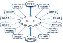
In this paper, we review and sort out research progress on development geography since the 20th century, involving its connotation and theory, fields and methods, and development trends in this paper. Specifically, we systematically reviewed the research and application of development geography in the fields such as in the convergence of underdeveloped countries or regions, the convergence in the process of improving the quality of life in developed countries or regions. Then, in line with the analysis of the research progress on development geography in foreign countries, we indicate the development conditions and disciplinary advantages of development geography in China. Further, we pointed that future development geography research in China should focus more on the latest international academic frontier research and national macro-strategic needs. The future research of development geography should be guided by the theory of sustainable development, with the core of improving the sustainable livelihood capacity and regional green development level in underdeveloped areas, and aiming at constructing industrial policy and development geography theory and interdisciplinary integrated research system, and focusing on research on the spatial pattern, diffusion characteristics and convergence mechanism of regional development, to explore the regulatory policies and scientific paths that serve regional economic construction and industrial development.
Feb. 25, 2020Vol. 75 Issue 2 226 (2020)
Enpu MA, Jianming CAI, Jing LIN, Hua GUO, Yan HAN, and Liuwen LIAO
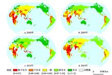
Food security is the basic foundation in accomplishing of the overall Sustainable Development Goals (SDGs). As the objective in SDGs of "halving the proportion of hungry people by 2015" has not been achieved as scheduled, it will become more challenging to realize its final goal of zero hunger by 2030. So exploring the underlying causes of global food security pattern from perspectives of spatio-temporal evolution is badly needed. In this paper, a comprehensive evaluation method with multi-indices was applied to evaluate the food security level of 172 countries in 2000-2014 based on an established global database with country-specific time series data. Then the spatial pattern and changing characteristics of global food security by country was conducted through the spatial autocorrelation analysis. Upon this basis, the underlying factors affecting the food security pattern were further identified and analyzed with a multiple nonlinear regression method. The findings and results show that: (1) The global food security pattern can be summarized as "high-high and low-low agglomerations" of socio-economic status and food security level. The most food secure countries are mainly distributed in the regions with more advanced economy such as North America, Oceania, parts of East Asia, and Western Europe. On the contrary, the least food secure countries are mainly distributed in sub-Saharan Africa, South Asia, West Asia, and parts of Southeast Asia. (2) At 99% confidence level, Western Europe and sub-Saharan Africa are respectively the hot and cold spots in global food security landscape, while in non-aggregation areas such as Haiti and North Korea, there exist long-term food insecurity problems. (3) The spatio-temporal pattern of global food security is generally stable, but the internal changes in the extremely insecure groups are significant. The countries with the most changeable levels of food security are also the countries with the most food insecurity. (4) Annual mean temperature, per capita GDP, the proportion of people who have access to clean water, and political stability are the key factors affecting the global food security pattern. The study indicates that while the global food security situation has improved since 2000, there was a reverse sign or omen in 2013. Affected by climate change, residents' purchasing power, infrastructure condition, and political and economic stability, global food security has in fact been volatile and some areas in the world are still facing acute food security problems. In addressing this challenge, a food security strategy based on the four dimensions, i.e. food supply, food access, food use and political stability, and a worldwide rural revitalization approach, is highly recommended. Meanwhile, it is necessary to progressively introduce some diversified modes of production such as urban agriculture to build a more resilient food system in those fully urbanized regions.
Feb. 25, 2020Vol. 75 Issue 2 332 (2020)
Daming LU, Xinjun YANG, Yuzhong SHI, and Ziqiao WANG
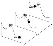
It is important to study rural transformation and development from the perspective of farmers' livelihood regime changes on the Loess Plateau. We selected cunties of Binxian, Changwu and Xunyi located in the apple growing area of the Loess Plateau, as a case study to construct the evolutionary path of rural regime, identify the micro factors that affect rural transformation and development, and reveal the mutual feedback mechanism between farmers' household regime and rural transformation. In doing so we adopted a regime change perspective, and applied the fuzzy analytic hierarchy process method, geodetector, and multiple linear regression. We obtained the following three findings. First, 27 of 130 selected samples, distributed mainly in areas with loess girder topography, belonged to the traditional agricultural regime. Meanwhile, 96 samples, distributed mainly in areas with loess tableland topography, belonged to the new agricultural regime. Another 7 samples, mainly distributed in valley areas, belonged to the non-agricultural regime. Second, when rural transformation sees the traditional agricultural regime replaced by the new agricultural regime, and finally the non-agricultural regime, the overall performance of rural development follows an inverted U-type development trend in a 3D space coordinate system. Simultaneously, rural population development follows an upward convex development trend in a 2D space coordinate system. Meanwhile, rural economic development follows an upward concave development trend, and agricultural production development follows an inverted U-type development trend, both in 2D space coordinate systems. Third, means of livelihood is the control variable that connects family system transformation and rural transformation development, which are determined by human and natural capital and directly affect financial and material capital at the farmer level. These aspects of transformation development are guided by the response process at the village level of three dimensions, namely population, economy and agriculture, and lead the process of rural transformation and development.
Feb. 25, 2020Vol. 75 Issue 2 348 (2020)
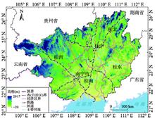
Shuangshuang TU, Yuhan ZHENG, Hualou LONG, Shimeng WAN, Xiaoli LIANG, and Wei WANG
Rural restructuring is an important means of implementing and pushing forward the strategy of rural vitalization. Systematic research on the characteristics and problems of rural development and restructuring in typical areas is the basis of developing scientific policies facing the strategic needs of rural vitalization in the new era. Taking Guangxi Zhuang Autonomous Region as a case, based on the TOPSIS model supported by entropy method, this paper analyzes the spatio-temporal pattern of rural development level and restructuring intensity, identifies the problem regions of rural development and restructuring, and explores the regional path of rural vitalization. The results show that, during the research period, the level of rural development in Guangxi has been rapidly improved, and the development of rural territory is moving from relative homogeneity towards heterogeneity. The average intensity of economic, social and spatial restructuring increases gradually in each research period, and economic restructuring is accelerating, while spatial restructuring is still lagging behind. The average coupling and coordination degree of economic, social and spatial restructuring has gradually improved, but the current level of coordination is still not high. Based on the above research, 37 counties in 7 categories are identified with problems in rural development and restructuring. The formation of problem regions reflects the impact of geographical environment, and is the result of the interaction of various factors such as terrain conditions, location conditions, natural resources, economic foundation, population quality and regional policies under the background of changes in socio-economic elements. The sustainable development in rural areas depends on the economic-social-spatial coordination, and the implementation of rural vitalization strategy in Guangxi requires not only the overall planning of the regional path of rural restructuring from the macro level, but also the regulatory measures to promote rural socio-economic development and spatial restructuring for problem regions.
Feb. 25, 2020Vol. 75 Issue 2 365 (2020)
Chunla LIU, Mei XU, Peilin LIU, and Fanchao ZENG
Cultural landscape protection compensation is a new topic in modern human geography. In this paper, we firstly proposed the theoretical framework of cultural landscape protection compensation of traditional villages, and then set up the cultural landscape protection compensation model on the basis of proposed theoretical framework. Finally, we discriminated the driving factors and offered a proof to the model, which takes Xiangxi nationality autonomous prefecture in Hunan province as a case study. The results can be concluded as follows: (1) From the aspects of the traditional architectural style, the location and pattern of villages, dynamical inheritance of the intangible cultural heritage of villages, and the level of their social and economic development of villages, traditional villages in Xiangxi conforming to the implementation conditions of cultural landscape protection compensation. (2) From the aspects of landscape characteristics and values, external market recognition, self-loss, government management, etc., cultural landscape protection compensation of traditional villages in Xiangxi conforms to the proposed cultural landscape protection compensation model. (3) From the aspects of its driving factors, cultural landscape protection compensation features of the 82 traditional villages in Xiangxi are in accordance with the comprehensive driving mode of landscape characteristics, government management, external market and self-loss. (4) In the traditional villages of Xiangxi, the cultural landscape protection compensation can be divided into three types, namely, social and economic compensation, historical and cultural compensation, and natural environment compensation. The factors of each type, such as social economy, historical culture, natural environment, all influence the structure of the compensation model.
Feb. 25, 2020Vol. 75 Issue 2 382 (2020)
Xiaoliang HU, Hongbo LI, Xiaolin ZHANG, and Yuan YUAN
Rural areas are the core concept of rural geography. The cognition of rural definitions guides the development direction of rural geography. Analysis of rural definitions has been a research hotspot in Western rural geography. Western rural geography is also developing with the deepening of scholars' understanding of rurality. The development of rural geography in China focuses on serving the needs of economic and social development, and there is little discussion on the principles and basic concepts of the discipline, which gradually leads to the situation that theory lags practice. The concept of rural areas is always changing. In recent years, there have been more and more studies on the rural diversified paths and multifunctional transformation and development. Historical experiences have proved that the connotation of rural concept has been constantly broken and subverted by the reality of rural transformation and development. The basic understanding of rurality in the past urgently needs to be changed and expanded, which also shows that the definitions of rural areas is worthy of continuous discussion. With the strategy of rural vitalization put forward, the development of rural areas in China in the new era is of unprecedented importance. This paper sorts out the evolutionary context of cognition of rural definitions and rurality in related research fields at home and abroad, and proposes that rural conceptual cognition gradually changed from single to multiple, from passive to active, from static characteristics to dynamic process. And then, this paper deepens the rural definitions based on the article "On discrimination of rural definitions". It points out that the difficulties in defining the rurality lie in the spatial dynamics of elements' flows, the unconformity of the rural space system, the relativity of the rural concept itself, and the new era background with rural vitalization strategy and urban-rural integration as the policy orientation behind the three characteristics. Finally, this paper prospects the future development of rural geography in China, and summarizes the importance of the analysis of rural definitions to the development of rural geography.
Feb. 25, 2020Vol. 75 Issue 2 398 (2020)
Hengyu GU, Xin MENG, Tiyan SHEN, and Nana CUI
It is demonstrated that the determinants of China's urban floating population's settlement intention are different among geographic units, which seems to be ignored by previous researches. Based on the data from the 2015 national migrant population dynamic monitoring survey (CMDS) and related statistics, this article uses the Semiparametric Geographically Weighted Regression (SGWR) model and k-means cluster method to examine the spatial variation of the factors influencing floating population's settlement intention in 282 prefecture- and provincial- level cites of China. Results provide the following conclusions. (1) The settlement intention of urban floating population is mainly influenced by the floating population characteristics instead of the destination characteristics. (2) Social and economic factors are closely related to the floating population's settlement intention. Meanwhile, the demographic, family and mobility factors exert a significant impact on such an intention. To be specific, there exists an inhibitory effect on floating population's settlement intention in factors such as income, marriage, and cross provincial mobility. However, housing expenditure, participation rate, number of children and other factors can effectively contribute to such intention. (3) Zonal spatial differentiation patterns of the influencing factors' coefficients are illustrated by the SGWR model, which can be further divided into four categories ("E-W", "N-S", "NE-SW" and "SE-NW"): The positive influences of ethnic and family factors are decreasing from the northern to southern regions, while the influence of employment ratio in the secondary industry is declining from the northwest to the southeast regions, and the impacts of factors such as the number of children and per capita GDP are diminishing from the northeast to the southwest regions. In eastern developed areas, the settlement intention of floating population with higher income is comparatively lower, while migrants with higher housing expenditure in southern China have a stronger intention to settle down. (4) Four influencing zones are detected by the k-means method: Floating population's settlement intention in North China, Central China and East China is significantly affected by multiple factors; In the northwest region and part of the southwest region, migrants' settlement intention is mainly influenced by demographic and social factors; The northeast region and the eastern part of Inner Mongolia's floating population's willingness to stay is mainly related to economic and family factors; Apart from housing expenditure, coefficients of other factors are relatively small in southern China and part of the central, eastern and southwestern regions. Additionally, this paper puts forward some suggestions on the service and management of the floating population in China.
Feb. 25, 2020Vol. 75 Issue 2 240 (2020)
Wei QI, Shenghe LIU, and Liang ZHOU
The Tibetan Plateau is regarded as a typically sparsely populated area both from Chinese and global perspectives. There exists a large difference in population distribution of the Tibetan Plateau. Based on the town-level census data in 2010, we compiled a spatial population database to calculate the population density of the Tibetan Plateau. We found that the population distribution on this plateau was characterized in four dimensions, namely longitude, latitude, polarization and altitude. In addition, similar to the "Hu Line" for Chinese population distribution, we introduce the "Qilian-Gyirong Line" (short for Qi-Ji Line), a spatial division line of population geography in the Tibetan Plateau. Our main results are summarized as follows. (1) There are significant regional differences in the spatial population distribution in the Tibetan Plateau. The population density in the southeast was higher than that in the northwest. Compared to longitude-oriented, latitude-oriented and altitude-oriented regional differences, the polarization-oriented regional difference of population distribution was more prominent. This finding indicates that fewer people live in areas close to the cold-arid core of the Tibetan Plateau. (2) The spatial population distribution is closely related to the natural and environmental factors, including altitude, soil, water resources, climate and vegetation. The interaction between the natural factors has an impact on enhancing the regional difference of population. (3) The "Qiji Line" reveals the spatial differences of population in the Tibetan Plateau. The areas on either side of the line are approximately similar, whereas the population shares in the southeast and northwest halves are 93% and 7%, respectively. (4) In general, the population differences on both sides of the "Qiji Line" were stable over time. During 1982-2010 the population share in the southeast half decreased counterbalanced by an increased share in the northeast half. In the future, the majority of the people are expected to live on the southeast side. This is likely to imply two major policy initiatives. More attention is required on the urbanization development and transportation network construction in the southeast half and the increasing eco-environmental pressures from the growing population in the northwest half.
Feb. 25, 2020Vol. 75 Issue 2 255 (2020)
Liang DING, Xinyi NIU, and Xiaodong SONG
Due to the lack of empirical studies of scale variables and distance exponents, the effective application of the gravity model in urban study is challenging. With the development of multi-centralized Chinese cities, the gravity model must be validated because several relevant external conditions have changed. The purpose of this study is to validate Huff's Gravity Model using an individual mobile trajectory of mobile communication user in 2015. We follow Huff's two-step validation method: variable validation and parameter correction. Our main conclusions are as follows. First, attractions of commercial and employment centres conform to the law of the gravity model in which the attraction is proportional to the scale of a centre and inversely proportional to the distance from a centre. Second, in the spatial scale of Shanghai central city with spatial units in a 200-m grid, the mean distance exponent for commercial centres is 2.5 and that for employment centres is 3.0. The distance decay for commuting is greater than that for shopping trips, which means commuting is more sensitive to distance. Third, the gravity model can be used to predict the influence areas of adjusted commercial and employment centres based on validated variables and corrected parameters. Our results indicate that the prediction accuracies can reach 78.5% and 71.9% for the commercial and employment centres, respectively. The prediction accuracy for employment centres is slightly lower. This is because the attraction of employment centres is influenced not only by distance but also by factors such as family and housing prices, which will affect the prediction results. Lastly, in this study, we verify the spatial stratified heterogeneity of distance decay and determine that the distance exponent is not a unique constant because it has different values in different areas. Factors such as accessibility, distance to each centre, distance to a subway station and population density will affect distance decay.
Feb. 25, 2020Vol. 75 Issue 2 268 (2020)
Jianji ZHAO, Yanhua WANG, Jue WANG, and Changhong MIAO
The spatial spillover effects of prefecture-level cities have impacts on the industrial structure of counties. An assessment of such impacts will have important theoretical and policy implications for deepening the "province governing county" (PGC) reform. This paper reviewed the process and characteristics of PGC reform in Henan Province. Based on an econometric model of county's industrial structure as well as in-depth interviews, the study examined how county empowerment and the spillover effects of prefectural cities affect the industrial structure of counties. Several findings deserve to be highlighted. First, during 2004-2016, the decentralization of economic authority accelerated the growth of the tertiary sector at the county level, whereas the decentralization of social power inhibited the output level for all industries. Secondly, the spillover effects of prefectural cities have opposite impacts on agriculture and non-agricultural industries, and the decentralization of economic authority amplifies the spillover effects. The trickle-down effects on agriculture are more noticeable in less developed counties, whereas the polarization effects on non-agricultural sectors (especially the tertiary sector) are more obvious in economically advanced counties. Thirdly, we argue that the delegation of economic authority could be implemented in a larger number of counties, though cautious steps need to be taken in delegating social management power. In more developed prefecture-level cities, the PGC reform should be conducted in agricultural counties; in less developed cities, by contrast, counties with higher level of industrialization should be chosen for the PGC reform.
Feb. 25, 2020Vol. 75 Issue 2 286 (2020)
Yaqun WU, Shuangshuang LI, Junping YAN, and Chengbo WANG
This study analysed the geographical development characteristics of Chinese universities from hierarchical and regional perspectives by establishing a publishing index, defining development patterns, and dividing relevant grades on the basis of academic articles during 1986-2018. The articles were published in the top four Chinese geographic journals: Acta Geographica Sinica, Geographical Research, Scientia Geographica Sinica, and Progress in Geography. We discuss the factors influencing the geographical development of Chinese universities. The results showed that (1) temporally, publication trends indicated an increase in geographical research in China from 1986 to 2018, which featured spatial agglomeration and quantitative hierarchy. So, we divided the number of publications into three categories (high, medium, and low) using systematic clustering analysis. (2) We examined the development history of different types of university involved in projects to promote the development of Chinese higher education by national and local governments. Universities sponsored by Project 985 were the largest contributors to the number of published articles, which formed the nucleus of geographical research, and universities sponsored by Project 211 contributed a medium-high number. For other universities, the annual number of published articles prior to 2006 was generally low and increased slowly. Since 2006, the number in some universities increased rapidly, while others remained low-stationary, showing the evolution of the coexisting pattern of high-medium-low categories. (3) Spatially, in eastern China, Beijing, Shanghai, Guangzhou, and Nanjing are centres of geographical research, ranking at the top in terms of geographical knowledge production. In addition, universities in the central region developed rapidly after 2004. Universities in the western region showed an asymmetric pattern, specifically, the northwest was stronger that the southwest. (4) The historical pattern of geographical research could be summarized using J, S, and linear curves. The findings revealed that the number of universities with J and linear curves was higher than those with S curves, while the number of universities that published papers at the middle and low levels was larger than those at the high level. In the future, geographical development will experience increasing improvement, although there is the external gap between the core and periphery for Chinese universities, i.e., between western and eastern universities, as well as with other universities and those sponsored by Projects 985 and 211. (5) A framework has been constructed to illustrate the development disequilibrium and factors influencing the geographical development of universities. It is suggested that future practices should not only involve the introduction of excellent research teams and the provision of policy support, but also the utilization of regional characteristics to cultivate teams that can achieve sustainable geographical development in China.
Feb. 25, 2020Vol. 75 Issue 2 302 (2020)
Zhenjie YUAN, Junwanguo GUO, Yunying YANG, and Hong ZHU
Education is not only important for strengthening a country's population quality and comprehensive power but key in reshaping the "man-land" relations in a country. This article reviews studies on the distribution of educational resources in both Chinese and Anglophone literature and summarizes the research gaps in the Chinese literature, which include but are not limited to the downplay of the analysis of mechanism and comprehensive effects of the spatial structure of educational resources. Employing different map-making technologies and mechanism-analysis methods, this article dives into three findings. First, though spatial features are slightly different between primary school level and middle school level, eastern regions generally have higher quality educational resources than western regions. In addition, urban agglomeration, including Beijing-Tianjin-Hebei, Shanghai-Ningbo-Hangzhou, and the Pearl River Delta, have an advantage in attracting and cultivating high-quality educational resources. Second, the quantity of high-quality primary school resources is positively correlated with annual per capita disposable income of urban households and number of full-time primary school teachers. The quantity of high-quality middle school resources is positively correlated with the comprehensive economic and social performance of the city. Third, when affected by multiple mechanisms, the spatial structure of China's high-quality educational resources is dynamic and deeply intertwines with the interrelations between cities as well as between the societies within each city. This article contributes both to the understanding of the unequal spatial structure of high-quality educational resources in China and to the analysis of complex socio-political effects on this transforming structure. Its findings encourage further research on the connection between the spatial structure of a region's educational resources and its cooperation and geopolitics as well as on the resulting social mobility among different social strata. Study limitations include: place-related elements, such as local political resources, were not sufficiently considered when selecting factors; there is a lack of longitudinal analysis; and not enough attention is paid to the combination of number-based data and geo-information-based data in analyses.
Feb. 25, 2020Vol. 75 Issue 2 318 (2020)
Lin LU, Qingyuan ZHANG, Yan XU, Jianfeng HUANG, and Yuchen XU
The relationship of power, capital and space is an important issue of the Marxist geography. In recent years, tourism destinations have been gradually connected to the globalization process through abundant spatial practices, providing vivid cases for the research in this field. Taking Wuzhen as a study case, this paper has put forward an analytical framework by putting together David Harvey's circuits of capital theory and Neil Smith's rescaling theory based on the literature review, which regards rescaling as a complex process formed by power and capital acting on a multi-scale space. Using the qualitative research method, this paper analyzes the rescaling of Wuzhen during its transformation from "pre-tourism stage" to "tourism stage" and finally to "post-tourism stage". The results of this study show that the rescaling of Wuzhen is a microscopic mapping of social and economic changes since China's reform and opening-up. The rescaling of Wuzhen is the result of a two-way comprehensive action of "top-down" and "bottom-up" at different scale levels, such as global, national, regional and local levels, and it has dual attributes as method and result under the interaction of power, capital and space. The logic of interaction between power, capital and space is the core mechanism of the rescaling of Wuzhen. The spatial practice of Wuzhen expands the research scope of power, capital and space relevance at a micro level. As a space unit between urban and rural areas, the glocalization space practice of Wuzhen has come out of a "compatible binary relation" realistic path, which is a reference to the improvement of the current imbalance of urban and rural development in China.
Feb. 25, 2020Vol. 75 Issue 2 410 (2020)
Weixuan SONG, Jie SUN, Yanru CHEN, Shanggang YIN, and Peiyang CHEN
Commercial gentrification has been a research frontier of gentrification. It refers to the phenomenon that the traditional business, residence or industry is replaced by business with higher value in the city. Its connotation includes: (1) renovation and renewal of commercial environment and material landscapes; (2) realization of the rent gap of commercial space; (3) the upgrading and succession of business and consumption culture; (4) advanced replacement of business and consumer groups. The social spatial characteristics of commercial gentrification show differences in different countries and regions, for different stages, modes and regulatory environments of urban development. Under the influence of economic globalization and western-style consumer culture, traditional residence or community business was replaced by restaurants with exotic customs, bars, cafes, gyms, and other high-end consumer places, which mainly meet the growing needs of the middle-class consumer groups. They gathered in the specific space of the city since the end of the 20th century. This is the typical commercial gentrification in China, which is a business upgrading and replacement process that meets higher consumer demand. Commercial gentrification in China has a more intense process, as well as a wider range of impact, than that in European and American countries. The paper conducts a kernel density analysis of the six high-end entertainment establishments in the inner city of Nanjing in 2008 and 2018. The result shows that: (1) the "hot spots" of commercial gentrification first appear in the traditional commercial centers and historic conservation areas, and then spread to the periphery of commercial centers and new commercial areas; (2) according to the difference of practice path, commercial gentrification in inner Nanjing can be divided into three modes of holistic implantation, invasive succession, and transformation and upgrading, which are respectively represented by 1912 blocks, NJU-NNU area and Xinjiekou area. Both economic and cultural forces play an important role in promoting the evolution of the three modes of commercial gentrification. The process of commercial gentrification is driven by both the supply side and the demand side, including the facts that local government and capital join hands to pursue commercial rent gap, as well as that young and high-income gentrification groups have a growing demand for fashion and high-end consumption. Commercial gentrification has promoted the business vitality and economic benefits of the city. Also, it has affected the authenticity of the historical blocks, the inclusiveness of the commercial space and the fairness of the space production to a certain extent, for its exclusion and displacement produce effects on the residents, and the low-end business and consumer groups. Commercial gentrification involves cultural identity, quality of life, consumption experience and status symbol, meaning that it has more complicated social spatial connotation than residential gentrification. Consequently, it is urgent to conduct a more systematic study on the phenomenon of commercial gentrification in China.
Feb. 25, 2020Vol. 75 Issue 2 426 (2020)
© Copyright 2018-2021 | Chinese Laser Press.
All Rights Reserved 沪ICP备15018463号-20