


Please enter the answer below before you can view the full text.

2020
Volume: 35 Issue 10
19 Article(s)

Wen-ze YUE... and Hao-xuan XIA|Show fewer author(s)
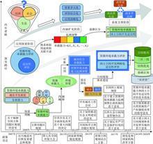
In response to the needs of hierarchy, diversity and difference in territorial spatial planning, this paper discusses the basic logic problems, application challenges and responses between resource and environment carrying capacit
Oct. 28, 2020Vol. 35 Issue 10 2299 (2020)
Fan YANG... and Le-feng LIU|Show fewer author(s)
"Double evaluation" is the system setting and technical foundation of territorial spatial planning system. Based on the practical cases, this paper gives theoretical reflection on the Trial Guide. The results show that the scienti
Oct. 28, 2020Vol. 35 Issue 10 2311 (2020)
Hao-xuan XIA... and Yang CHEN|Show fewer author(s)
The evaluations of resources and environment carrying capacity and territorial space suitability ("double evaluations") play a fundamental role in the new territorial spatial planning system, which is crucial for the scientificity
Oct. 28, 2020Vol. 35 Issue 10 2325 (2020)
Xiao-qing ZHAO... and Jun-xu CHEN|Show fewer author(s)
The coordinated development of territorial space is the premise of regional sustainable development. How to optimize the territorial space structure and build a reasonable control model has become one of the important issues that
Oct. 28, 2020Vol. 35 Issue 10 2339 (2020)
Shu-hai ZHANG, and Duan-bin RUAN
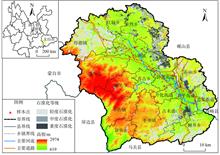
The resources and environment carrying capacity is an important basis for measuring the resource conditions of a region and guiding the spatial distribution of land. In the current evaluation research of resources and environment
Oct. 28, 2020Vol. 35 Issue 10 2358 (2020)
Jing WANG... and Zi-qiu SONG|Show fewer author(s)
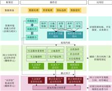
Scientific cognition and evaluation on resources-environment carrying capacity is the basis and prerequisite for territorial spatial planning. From the perspective of sustainable urban ecosystem management, the evaluation framewor
Oct. 28, 2020Vol. 35 Issue 10 2371 (2020)
Long LI... and Zhao-hua FENG|Show fewer author(s)
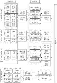
The purpose of this paper is to simplify the "double evaluations" mechanism and evaluation process, build an index system with karst characteristics from the perspective of ecological civilization to identify the advantages and di
Oct. 28, 2020Vol. 35 Issue 10 2385 (2020)
Guang-xin XIANG... and Yi ZENG|Show fewer author(s)
To construct the model of "Ecology-Agriculture-Construction Comprehensive Planning" for delimitation techniques of urban development boundary, this paper calculates the proposed scale of county construction and development under s
Oct. 28, 2020Vol. 35 Issue 10 2401 (2020)
Zhen-tao ZHONG... and Wei-ling LUO|Show fewer author(s)
The national spatial planning system in the new era of ecological civilization has put forward targeted requirements for the baseline control of territorial space. Both of "double evaluation" and monitoring-evaluation-warning of n
Oct. 28, 2020Vol. 35 Issue 10 2415 (2020)
Dan YI... and Xin-yi HUANG|Show fewer author(s)
Delimiting three lines (permanent basic farmland protection zones, urban growth boundaries and ecological protection redlines) scientifically is conducive to rational arrangement of land space resources and identifying the "three-
Oct. 28, 2020Vol. 35 Issue 10 2428 (2020)
Yu LIU... and Hao-sen WANG|Show fewer author(s)
Under the background of rapid urbanization, agricultural development in Beijing has shrunk sharply and the marginalization of agriculture is becoming more and more obvious. Recently, Beijing puts forward the development model of r
Oct. 28, 2020Vol. 35 Issue 10 2444 (2020)
Xiang LUO... and Zuo ZHANG|Show fewer author(s)
Examining the poverty trap and its causes is the basis for understanding the mechanism of poverty reduction and governance. Current research no longer confines rural poverty to "insufficient capital formation", but emphasizes the
Oct. 28, 2020Vol. 35 Issue 10 2460 (2020)
Xiao-fang HU... and Jing-wang LI|Show fewer author(s)
Compared to traditional hotels, the price of homestay inn has unique spatial distribution characteristics and influencing factors. This research, taking the homestay inn price of Enshi Tujia & Miao Autonomous Prefecture in Hubei p
Oct. 28, 2020Vol. 35 Issue 10 2473 (2020)
Ke HE, and Jun-biao ZHANG
On the background of the acquaintance society and atomized society in rural areas, this paper employed game theory and simulation to analyze the contradiction between individual rationality and collective rationality among pig far
Oct. 28, 2020Vol. 35 Issue 10 2484 (2020)
Sheng-yuan MI... and Zhen-kai WANG|Show fewer author(s)
It is of great significance to study the spatial and temporal evolution and driving mechanism of multi-cropping rice area to ensure Chinese grain production and security. The Nich index and geo-detector model were used to explore
Oct. 28, 2020Vol. 35 Issue 10 2499 (2020)
Shu-ting CHEN... and Wen-na YANG|Show fewer author(s)
The Qinghai-Tibet (QT) Plateau is considered as the "natural laboratory" of climate change in China and even in the world. Under the background of global change, the vegetation ecosystem of the QT has undergone profound changes. I
Oct. 28, 2020Vol. 35 Issue 10 2511 (2020)
Yi-zhen LEI... and Hua-fei LI|Show fewer author(s)
Hydrogen and oxygen stable isotope technology is an effective method to study the surface water-groundwater interaction. Based on the hydrogen and oxygen isotope component (δD and δ18O) of precipitation, river water and groundwate
Oct. 28, 2020Vol. 35 Issue 10 2528 (2020)
Wen-jun LI... and Yue-ji QI|Show fewer author(s)
The strong El Nino in 2015 caused droughts, little rainfall and intensified active fires in Southeast Asia (SEA). To our knowledge, the spatio-temporal characteristics, occurrence types and intensity of active fires as well as the
Oct. 28, 2020Vol. 35 Issue 10 2539 (2020)
Hao-zhe YU... and Jiu-yi LI|Show fewer author(s)
The Beijing-Tianjin-Hebei region is one of the main producing areas of high-quality winter wheat in China, but drought disasters frequently occur in this region under the influence of global warming. Accurate monitoring of drought
Oct. 28, 2020Vol. 35 Issue 10 2553 (2020)
© Copyright 2018-2021 | Chinese Laser Press.
All Rights Reserved 沪ICP备15018463号-20