


Please enter the answer below before you can view the full text.
7+7=

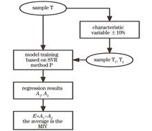
This study proposes a method based on a convolutional neural network (CNN) and support vector regression machine (SVR) for predicting the vertical distribution of NO2 in the troposphere by multi-axis differential optical absorption spectroscopy (MAX-DOAS) technology. Taking the Nanjing site as an example, we obtain the O4 and NO2 differential slant column density (dSCD) according to the raw MAX-DOAS data collected by QDOAS fitting in 2019, invert the tropospheric NO2 profile by combining the optimal estimation-based aerosol and trace gas profile inversion algorithm-PriAM, and use the profile as the output of the prediction model. In addition, the input variables of the prediction model are selected by the mean impact value method, with MAX-DOAS data, temperature, aerosol optical thickness, and low cloud coverage finally identified as the optimal input variables for the model. Furthermore, the network structure and parameters are optimized through experiments, and the average percentage error of the final CNN-SVR prediction model in the test set with PriAM is only 9.14%, which is 8.22%, 6.00%, and 32.28% lower than that of the separately constructed CNN, SVR, and backpropagation models, respectively. Therefore, CNN-SVR can effectively predict tropospheric NO2 profiles by using MAX-DOAS data.
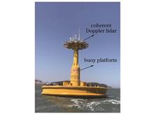
Lidar is able to provide atmospheric wind field data with high spatial-and-temporal resolution. To improve the observation precision of lidars on offshore buoys and other moving platforms, an inversion algorithm for the wind field in the marine atmospheric boundary layer based on a floating wind lidar system is investigated. With the data observed by the self-developed floating wind lidar system, the methods of correcting the attitude and radial velocity of the buoy platform, the velocity-azimuth display (VAD)-based inversion method for the wind field, and the data quality control method are employed to improve the accuracy of the inversion results of wind profiles. The results of the simultaneous observation experiments are compared with the inversion results of the wind profiles for verification. The comparison shows that the matching errors in the horizontal wind speed and wind direction are 0.3 m/s and 2.0°, respectively, and the coefficients of determination of the two factors are 0.986 and 0.996, respectively, indicating the accuracy of the proposed inversion algorithm for wind profiles based on floating lidar.
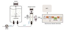
This paper takes mixed algae as the research object to study the influence of single cell variable fluorescence (SCVF) differences of algal species in mixed samples on the accuracy of variable fluorescence statistical analysis. The research results show that when the SCVF ratio of two algae is no more than 5.3, the analysis is still applicable, and the mean absolute value of the relative errors between measurement results and microscopic examination results is no more than 17%. When the SCVF ratio of two algae is higher than 8, the measurement results are quite different from the microscopic examination results. In addition, when high SCVF algal cells account for a large proportion, the measurement results of variable fluorescence statistical analysis only reflect the number of high SCVF algal cells in the mixed samples. As a result, for the mixed algae with large differences in SCVF, the paper combines a filtration separation method with the variable fluorescence statistical analysis method. The mixed samples are filtered by a metal filter screen with suitable pore size, and the density sum of measured viable algal cells before and after filtration is taken as experimental result. The results show that the proposed method can greatly reduce the mean absolute value of the relative error from 58.4% to 5.5%, effectively mitigate the influence of the SCVF difference of algal species in mixed samples on the quantitative analysis of cell number, and accurately quantify viable cells in mixed algae.
The flow around the turret causes serious aero-optical effects, consequently limiting the effective performance of airborne laser weapons. Therefore, researching the suppression of aero-optical effects of a turret has become a real urgency. In this paper, high-precision numerical simulation methods are used, and wind-tunnel verification experiments are conducted, to provide high-confidence time-series wavefront data. On this basis, the curve and scatter plot of correction residual variation with correction order in the airspace are developed for quantitative evaluation of adaptive optics correction. The results show that complex structures, such as shedding vortex streets, are observed in the flow field around the turret, and shock waves also appear when the Mach number is large. The aero-optical effect of the top view is the strongest, while the steady-state aberration of the front view accounts for a large share of the whole. Moreover, the dynamic aberrations of the top view and the rear view assume large proportions, and shock waves further increase the dynamic aberration ratios of the wavefront. The front view can achieve a satisfactory adaptive optics correction effect, while the correction of the top view is difficult as it requires a high wavefront fitting ability of the deformation mirror for adaptive optics correction. Therefore, joint suppression methods, such as combining adaptive optics correction and flow control, are recommended to suppress aero-optical effects of a turret.
For the polarized scanning atmospheric corrector (PSAC) onboard the Huanjing Jianzai-2A/B (HJ-2A/B) satellites, this study analyzes the noise terms in the signal chain and their correlation with the signal in detail and builds a signal-total noise power linear (S-TNPL) model. Experimental measurements are conducted to obtain the coefficient of the model in which the noise power of each channel only varies with the signal and the background noise power (intercept) that is related to operating conditions rather than to the signal. An on-orbit signal-to-noise ratio (SNR) evaluation method independent of homogeneous regional scenes is developed with background noise measured on orbit and is then verified by a comparison with the onboard diffuser method. The comparison shows that the results of the on-orbit SNR evaluation of the PSAC obtained by the proposed S-TNPL model and the onboard diffuser method exhibit a relative deviation of -0.62%-6.27%, indicating favorable consistency and thus verifying the validity of the proposed on-orbit SNR evaluation method. This SNR evaluation method can not only adapt to degrading on-orbit radiation performance but also facilitate the conversion of SNRs under different radiance conditions. Moreover, it can be directly applied to evaluate the SNR of the result of any single observation. The SNR analysis method in this paper is also applicable to other optical remote sensors theoretically and can thus provide a reference for the on-orbit SNR evaluation of such remote sensors.
An optical flow calculation method is proposed based on median absolute deviation (MAD) to estimate the refractive index structure constant of near-surface atmospheric turbulence, namely, Cn2. Specifically, this paper captures the jitter information of adjacent target images with multiple frames shot by a telescopic system through optical flow calculation and obtains the mean value of the angle-of-arrival fluctuation variance on the transmission path, so as to estimate the refractive index structure constant of near-surface atmospheric turbulence. Subsequently, a 6-day observation experiment is carried out in Hefei, and the mean value of Cn2 estimated by the model is comprehensively compared with the results measured by a micro-temperature sensor on the observation path. As a result, in terms of estimated and measured values, the mean deviation (BIAS), root-mean-square error (RMSE), and correlation coefficients are -0. 0202, 0. 2391, and 0. 8230, respectively. Therefore, it is fully proved that the proposed method can effectively estimate the refractive index structure constant of near-surface atmospheric turbulence and provide reference for the inversion of atmospheric turbulence parameters based on images.
Descriptors in lidar closed-loop detection algorithms such as Intensity ScanContext (ISC) are easily disturbed by carrier rotation and translation variations, and their invariance is weak, which leads to poor closed-loop effect. In view of these problems, a lidar point cloud descriptor with rotation and translation invariance in an urban dynamic environment is proposed. Firstly, in terms of point cloud processing, a ground point segmentation algorithm based on angular images is used to remove ground points in point cloud data, and a dynamic target elimination algorithm based on curved voxel clustering is adopted to realize point cloud segmentation and remove dynamic targets. Secondly, Coordinate system transformation of point clouds are carried out based on quaternions collected by an inertial measurement unit, and the point clouds in all frames are unified under the same heading angle, so as to realize the rotation invariance of the descriptor. In addition, the relative position relationship between the static targets in the point clouds and the normal plane where the moving direction of the carrier is located is used to determine the rendering center of the descriptor, so as to realize the translation invariance of the descriptor. Finally, the proposed descriptor is used for closed-loop detection, and the consistency of the closed-loop detection results is verified according to the spatial structure of the point cloud data. The experimental results under the KITTI public dataset show that the proposed method can achieve closed-loop detection more quickly and accurately in an urban dynamic environment. Compared with that of the ISC algorithm, the recall rate of the proposed method is improved by 8.58 percentage points at an accuracy of 100%, and the average time consumption is reduced by 12.90%.
To quickly predict and evaluate the effects of turbulence and thermal blooming on the beam spreading during high-energy laser (HEL) propagation in atmosphere, this study examined the scaling law for the beam spreading during laser propagation in atmosphere. By calculating the variation law of the simulated beam spreading with characteristic parameters of atmosphere and laser parameters, the paper built a scaling relationship for the beam spreading during laser propagation in atmosphere with both the turbulence effect and the thermal blooming effect. This scaling relationship reveals that when the initial beam quality of the laser is poor, the beam spreading caused by diffraction and turbulence grows with the ratio of the aperture of the transmitting system to the atmospheric coherence length at a faster rate. Also, the effect of thermal blooming on beam spreading intensifies as the Fresnel number of the transmitting system increases. The established scaling relationship performs well in rapidly predicting and evaluating the beam spreading laws of lasers with different powers under turbulence and thermal blooming effects of different intensities. Therefore, it can provide a reference for the design and optimization of laser systems.
To solve water surface glint interference problem in the reconnaissance, detection, and recognition of water surface and underwater targets, this paper uses polarization characteristics to suppress water surface glint and enhance targets. For this purpose, the propagation laws of the polarization characteristics of light waves during the reflection and refraction of such waves at the water surface are analyzed. According to the relationship between the intensity distributions of light waves in perpendicular and parallel directions, this paper proposes a suppression method for water surface glint based on the reflection and refraction polarization effects. This method achieves the separation and suppression of water surface glint by using the degree of reflection polarization, the degree of refraction polarization, the perpendicular light intensity image, and the parallel light intensity image. A saturated light intensity restoration method based on complete polarization decomposition is proposed to address the problem of saturation distortion of the perpendicular light intensity image in the suppression of saturated glint. The perpendicular light intensity image can be calculated and restored with the parallel light intensity image and the light intensity image obtained in any unsaturated polarizing direction. Then, the restored perpendicular light intensity image can be used to suppress the saturated water surface glint. The experimental results show that the suppression of the water surface glint effectively increases both the contrast and the signal-to-noise ratio between the target and the background in the glint area and thereby enhances the prominence of the target.
When wireless ultraviolet light is availed for non-line-of-sight scattering communication in the atmosphere, the scattering and absorption of atmospheric particles and the change in low-altitude atmospheric turbulence have a substantial impact on the performance of ultraviolet communication (UVC). This study builds a link model for wireless ultraviolet non-line-of-sight (NLOS) single-scattering communication under low-altitude atmospheric turbulence. Then, computer simulation is performed to analyze the system's communication performance, such as the light intensity distribution characteristics, signal-to-noise ratio, and signal attenuation, in NLOS scattering communication under different factors, including the ranges of the transmitter and the receiver, the refractive index structure parameters, and the pointing angle, and the effect of altitude variation on UVC during the day and at night. The simulation results reveal a gap between the performance of wireless UVC during the day and at night under turbulence changes at different heights. In the cases of horizontal communication, vertical communication, and oblique communication, the atmospheric refractive index structure constant at night increases by an order of magnitude compared with that under the weak turbulence condition, and the signal energy attenuates to 1/2.09, 1/2.16, and 1/2.03 of the original values, respectively, on average. The atmospheric refractive index structure constant during the day increases by an order of magnitude compared with that under the weak turbulence condition, and the signal energy attenuates to 1/2.07, 1/2.15, and 1/1.96 of the original values, respectively, on average. Clearly, communication at night is more affected by turbulence, and communication performance during the day is better than that at night. Moreover, turbulence has a greater impact on vertical communication.
Considering the problems of severe scattering, unclear target imaging, and low contrast in high-turbidity water environments, a residual Unet (Mu-UNet)-based de-scattering algorithm for underwater Mueller matrix images is proposed on the basis of the traditional UNet structure and polarization imaging theory. According to the intensity and polarization information of targets provided by Mueller matrix images, this algorithm establishes the image data sets of multiple targets under different turbidities. The residual module is introduced on the basis of UNet, and the Mu-UNet is used to extract the underlying information of the targets, which learns the characteristics of the labeled images and finally reconstructs the underwater target images with high contrast and detailed information. The comparative experimental results reveal that compared with the original image, the image restored by the proposed algorithm is improved by 89.40% in the peak signal-to-noise ratio, and the structural similarity is improved by 82.37%. Compared with traditional algorithms and UNet, the proposed algorithm can obtain restored images with a more significant de-scattering effect and finer details, which provides a new idea for the detection and high-quality imaging of underwater polarization.
Due to the significant nonlinear radiometric differences between synthetic aperture radar (SAR) and optical images obtained by satellite remote sensing, the current SAR and optical images registration algorithms are weakened by their poor real-time performance and weak rotation and scale invariance. To address the problem that the current algorithms only focus on the appearance information on the local features of images and ignore the geometric structure information, a SAR and optical image matching method combining the convolutional and graph neural network (GNN) is proposed. The method uses the convolutional neural network for feature detection and description, and adopts the GNN for feature matching. In contrast to the nearest neighbor matching algorithm that merely uses local descriptor information, the GNN embeds the location coordinates of feature points into the descriptors, thereby providing the descriptors with geometric location information. Then, the geometric context information of the feature descriptors is further aggregated with the attention mechanism. Finally, the matching results of the feature points are directly output by the differentiable optimal transport algorithm to ensure that the network can be trained in an end-to-end manner. The experimental results show that the proposed method achieves state-of-the-art performance on the registration task featuring rotation and scale variation in a large range. In addition, compared with the current mainstream registration algorithm radiation-invariant feature transform, the proposed method not only improves matching accuracy, but also increases the computational speed by more than 50 times.
Aiming at the multi-frame short exposure image overlay, this paper proposes a method that integrates the angle information of the imaging system and obtains the image offset pixels through the coordinate transformation calculation between the optical system and the camera system. For the angle of each frame of a short-exposure image, the geometric relationship of the optical system is used to perform sub-pixel offset registration, and the Fourier spectral filter H(u, v) is constructed through the frequency shift characteristic of the Fourier transform. The image is corrected at the sub-pixel level in the frequency domain, and the high-frequency response of the image is evaluated by the edge method. Compared with that of the unrepaired image, the line pair of the image corrected by the proposed algorithm is increased from 20 lp/mm to 33 lp/mm at a modulation transfer function (MTF) attenuation of 50% (MTF50), with its repair effect higher than that of the traditional quadratic interpolation algorithm. The proposed algorithm shows a positive repair effect in the line pair part of 40-80 lp/mm, and the peak value of the MTF is increased by four times.
This paper designs and develops a Compton camera system suitable for nuclear decommissioning scenarios with a detector containing a 23×23 array of cerium-doped gadolinium aluminum gallium garnet [GAGG(Ce)] and row/column readout circuits. The detector is composed of an array of GAGG(Ce) coupled with silicon photomultipliers (Si-PMs). A subset-driven origin ensemble iteration (SOE) algorithm based on graphics processing unit (GPU) acceleration is developed to accelerate the reconstruction process. After development is completed, the detector performance and system performance are evaluated. In terms of detector performance, the energy resolution and position resolution of the developed camera are 6%±0.6% at 662 keV (full width at half maximum) and 2.2 mm, respectively. The detector also exhibits favorable energy linearity (goodness of linear fit R2=0.991). Regarding imaging performance, the initial imaging of a 137Cs point source with an activity of 1.11×10⁷ Bq takes only 20 s when it is placed at 3.4 m in front of the imaging system. The angular resolution of the imaging system is 7°@JND (just noticeable difference). Finally, a simulation is carried out in the application scenario. The results show that the Compton camera developed in this paper can simultaneously image and position multiple radioactive sources within the π field of view. It can be used in radioactivity measurement in nuclear decommissioning to reduce the exposure dose of operators.
To deal with issues such as less feature information and difficult positioning raised by small object detection in remote sensing images, this paper proposes a remote sensing image small-target detection algorithm FFAM-YOLO (Feature Fusion and Attention Mechanism YOLO) based on feature fusion and attention mechanism. Firstly, in terms of inadequate effective information in backbone network feature extraction and weak information representation in feature maps, the algorithm constructs a feature enhancement module (FEM) to fuse multiple receptive field features in lower-level feature maps and improve the network's ability in extracting object features. Secondly, with low-level and high-level feature maps obtained by the backbone network, the algorithm's low-level and high-level feature fusion structures are rebuilt, and a feature fusion module (FFM) is implemented to enhance the feature information of small targets. Thirdly, small object features are accurately captured by cascade attention mechanism (ESM) consisting of enhanced-efficient channel attention (E-ECA) and spatial attention module (SAM). Finally, the small object is detected in the output dual-branch feature maps, and results are delivered. The experimental results show that with the USOD (Unicorn Small Object Dataset), based on the constructed remote sensing images, the proposed algorithm achieves a precision of 91.9% and a recall of 83.5%, with an average precision APof 89% for intersection ratio threshold (IoU) between the prediction box and the ground truth box of 0.5 andanAP of 32.6% for IoU of 0.5∶0.95, respectively, and the detection rate reaches 120 frame/s. The algorithm is with robustness and real-time performance.
To effectively correct the spectral line curvature of a transmission dispersive imaging spectrometer system, this paper proposes a distortion compensation method based on the off-axis slit. Specifically, the variation in the incident angle of the dispersive element with slit length is calculated on the basis of the assumed correction of the spectral line curvature of the central wavelength. Then, the slit is moved away from the optical axis of the collimator, and the target incident angle of the dispersive element is obtained based on the distortion of the collimator. The Smile distortion (spectral line curvature) of the central wavelength is thereby corrected. The Smile distortion and Keystone distortion (color distortion) of the remaining wavelength curve outward, and overall pincushion distortion is observed. Finally, the remaining spectral line curvature is corrected with the distortion of the converging lens. A reflection grating imaging spectrometer is designed by the proposed method, and the spectral line curvature of the system is corrected with the distortion of the collimator on the premise that the various parameters meet the design requirements. A principle prototype is developed on the basis of the above design. The system achieves a maximum Smile distortion of 12.9 μm and a maximum Keystone distortion of 6.4 μm. The test results meet the design requirements of the system and thus prove the feasibility of the proposed method.
This paper proposes and experimentally validates a large-scale multi-antenna and one-receiver global navigation satellite system (GNSS)-over-fiber differential positioning system using silicon on-chip optical routing. The radio-over-fiber (RoF) distributed antenna architecture is utilized to facilitate remote multipoint GNSS signal acquisition, and RoF transmission links featuring low loss, large bandwidth, and immunity to electromagnetic interference are reaped to achieve the centralized reception of remotely collected GNSS signals at the local end. At this end, a complementary metal-oxide-semiconductor (CMOS)-process-compatible high-speed silicon optical switch chip is fabricated for the periodic switching and differential calculation of GNSS signals over fiber obtained at different monitoring points. Then, a time-division multiplexing-based multi-antenna and one-receiver GNSS positioning system using on-chip optical routing is built. In the experiments, a self-developed 1×8 thermo-optic silicon optical switch chip based on a Mach-Zehnder interferometer is employed to build an experimental multi-antenna GNSS positioning system with five remote monitoring points. The RoF transmission distance of the GNSS signals is 10 km. According to the experimental results, the real-time response time of the optical switch chip module is less than 200 μs. Stable and high-accuracy positioning at five remote monitoring points (10 km away) is achieved without the aid of additional optical amplification. The obtained positioning accuracy in the east (E), north (N), and up (U) directions is all at the millimeter level.
As the research on space-borne LiDAR in China is insufficient, we explore the hybrid source photogrammetry of optical remote sensing images and space-borne LiDAR. The surface-element trajectory matching of digital elevation model (DEM) is performed on photon data of space-borne LiDAR to establish the correspondence between the trajectory of laser altimetry points and the digital surface model (DSM) generated by remote sensing images. Then, the selected ground photons and high-resolution optical remote sensing images are combined with the joint block adjustment method. By the iterative solution method considering coordinate errors of laser altimetry points, the stereo positioning accuracy of satellite remote sensing images can be promoted. The data ATL03 of space-borne LiDAR, as well as satellite remote sensing images from Gaofen-7 (GF-7) and Tianhui-3 (TH-3), are used to verify the performance of the method. The experimental results indicate that the proposed method can effectively improve the stereo positioning accuracy of satellite remote sensing images without ground control points, and the elevation accuracy can reach 1.258 m.
We propose a millimeter-wave radar and dual-wavelength lidar combined model for the microphysical and optical properties of water cloud particles. On this basis, we build the relationships of the effective radius and reflectivity-extinction ratio, as well as reflectivity-backscattering ratio of water cloud particles. Assuming the effective radius of the cloud droplet at the reference height and the lidar ratio at the next range gate, we can obtain the backscattering coefficient at the boundary value using the effective radius and backscattering coefficient inversion errors by dual-wavelength as constraints. Moreover, we employ Fernald backward integration method for the inversion of the aerosol profiles under water cloud conditions. The correlation coefficient between the simulated effective radius and that after algorithm processing is 0.98, and the correlation coefficient of the dual-wavelength backscattering coefficient is 0.81. The case studies indicate that this method can give rise to better inversion continuity of aerosols under water cloud conditions and a relatively accurate backscattering coefficient.
Under ideal clean atmosphere conditions, the backscatter signal intensity of micro-pulse lidar has a monotonic variation with height. An inversion algorithm of cloud vertical structure based on the interpolation and reconstruction method is proposed to screen the corresponding interpolation points in the pre-processed signal for Akima interpolation, with the places with the lowest and highest detection distances as the starting point and reference point, respectively. The obtained forward and backward reconstructed signals are further averaged to simulate the cloud-free signal. Clouds and aerosols are first distinguished by the proposed algorithm combining the adaptative threshold and empirical threshold to determine the candidate cloud interval. On this basis, the intensity of the simulated cloud-free signal is compared with that of the pre-processed signal, and the cloud base and cloud top heights of the candidate clouds are extracted. The validation using micro-pulse lidar data shows that compared with the results of the traditional direct inversion algorithm, the correlation coefficients of the cloud base and cloud top are improved to 0.9836 and 0.9334, and the root mean square errors are reduced to 43.8 m and 280.2 m, which indicates that the proposed method effectively improves the accuracy of cloud detection.
Given the large scale, uneven distribution, and large scale changes of small targets and the complex background in remote sensing images, an improved cascade algorithm SA-Cascade is proposed. This algorithm uses a recurrent feature pyramid network to strengthen the feature representation generated step by step, thereby improving the detection rate of small targets. The region proposal generation network based on the learnable anchor is utilized to locate the remote sensing target accurately. The feature adaptation module and feature fusion module are introduced to improve the performance in detecting images with complex backgrounds. On the basis of the cascade algorithm, the two-branch detection head is adopted to improve the performance of the model for detecting small targets. A comparative experiment of various algorithms is performed on TGRS-HRRSD-Dataset and VisDrone-DET dataset. The experimental results show that the improved cascade algorithm can detect and locate remote sensing image targets more accurately. Compared with the original cascade algorithm, the improved one increases the accuracy on the two datasets by 2.94% and 9.71%, respectively.
This paper proposes a wavelet-spatial high-order feature aggregation network (WHFA-Net) which can be divided into two branches: wavelet domain feature extraction and spatial domain feature extraction. Firstly, a Harr wavelet transform is embedded into convolutional neural networks (CNNs), and low-frequency components of the depth-wise convolutional features are retained as wavelet depth features. Secondly, depth feature learning is performed by the max pooling, and then the output is used as spatial depth features. In addition, the wavelet domain and spatial domain depth features are vectored, and their auto-correlation and cross-correlation high-order depth feature vectors are obtained. Feature regularization, feature aggregation, and feature normalization are then performed in sequence. Finally, a cross-entropy loss function is utilized for end-to-end network training. The experimental results on NWPU45 (NWPU-RESISC45 Dataset) and AID (Aerial Image Dataset) show that compared with that of the benchmark network (VGG-16), the accuracy of the proposed WHFA-Net in scene classification is improved by 5.13%-12.12%. Furthermore, compared with DCCNN, APDC-Net, GBNet, LCNN-BFF, MSCP, and Wavelet CNN, the accuracy of WHFA-Net in scene classification is higher. Additionally, the effectiveness and performance differences of each module and branch are verified through the ablation experiments. Therefore, WHFA-Net can effectively and stably extract the high-order aggregated features of different feature domains in remote sensing scene images and accurately perform scene classification.
To realize the synchronous measurement of temperature and salinity of seawater, we study a data inversion method by combining frequency shift and line width of stimulated Brillouin scattering (SBS) theoretically and experimentally. Theoretically, the variations of frequency shift and line width of SBS with the changes in temperature and salinity are fitted by empirical formulas. Experimentally, the frequency shift and line width of SBS in seawater with different temperatures and salinity are measured, and then the temperature and salinity of seawater are analyzed by the theoretical inversion model. The results indicate that the simultaneous inversion of seawater temperature and salinity can be realized by the combination of frequency shift and line width of SBS. The minimum and maximum temperature inversion errors are 0.04 ℃ and 0.41 ℃, respectively, and the minimum and maximum salinity inversion errors are 0.09‰ and 0.65‰, respectively.
On the basis of the imaging model of an interferometric imaging spectrometer, a novel model with a priori constraints is proposed to recover spatial and spectral information simultaneously. The nonnegative low rank property and total variation (TV) regularization are adopted to constrain the strong spectral correlation and spatial piecewise smoothness of recovered hyperspectral image, respectively. Meanwhile, the sparse noise and Gaussian noise in interferometric data are modeled by the L1 norm and Frobenius norm, respectively. The effectiveness of the proposed method is verified through comparative experiments on simulated and real interferometric data. Compared with traditional recovery methods for interferometric data, the proposed method not only recovers the spectral information of the object accurately but also effectively eliminates the degradation effect of mixed noise in the interferogram. As a result, the data quality of the recovered hyperspectral image is improved.
The Infrared Hyperspectral Atmospheric Sounder II (HIRAS-II) is mounted on China's Fengyun-3E satellite (FY-3E), a meteorological satellite in dawn-dusk orbit. The high geolocation accuracy and radiometric calibration accuracy of the instrument are the keys to the quantitative application of its observational data. The relative deviations of geolocation and radiometric calibration of HIRAS-II are evaluated via cross-comparison by the Moderate Resolution Spectral Imager-Low Light (MERSI-LL) mounted on the same satellite platform. After the observational data samples of the two instruments are spatially matched, the MERSI-LL data is used to evaluate the observation background uniformity of the matched samples. The geolocation accuracy of HIRAS-II is evaluated with non-uniform background observation samples of sea-land or cloud boundary, and its radiometric calibration accuracy is evaluated with homogeneous background observation samples of clear-sky ocean and other scenes. Before cross-comparison, the hyperspectral simulated observational data of each infrared channel in MERSI-LL is obtained by integrating the HIRAS-II observed radiation spectrum with the spectral response function of each infrared channel in MERSI-LL. The results show that the geolocation of HIRAS-II at nadir deviates by 3.53 km in the along-orbit direction and 2.01 km in the cross-orbit direction. In terms of radiometric calibration accuracy, the mean radiation brightness temperature (BT) deviations of most channels in HIRAS-II and MERSI-LL are lower than 0.50 K, and the standard deviation of the deviations is lower than 0.40 K. Only the deviation of the 4.05 μm channel is large to the low-temperature target, and the temperature dependence of this channel is obvious. The BT deviation of the 4.05 μm channel fluctuates while that of the 8.55 μm channel does not change significantly with the scanning angle. The variations in the BT deviations of the other channels with the scanning angle are related to the target temperature. The long time series analysis of the BT deviation shows that it remains stable as a whole.
According to spectral characteristics of apparent modulation transfer function (MTF) of turbid atmosphere, this paper proposes a new imaging quality evaluation factor to select optimal bands and obtains the imaging quality in different bands. Furthermore, the paper analyzes factors affecting optimal bands and summarizes optimal bands under typical atmospheric conditions and typical bandwidths. It is found that relatively universal and favorable images can be obtained in the bands of 1036-1046 nm and 1620-1630 nm. Finally, the effectiveness of the proposed method is verified by imaging experiments.
The rapid and efficient adsorption of heavy metal Cr by Chlorella pyrenoidosa is combined with X-ray fluorescence (XRF) spectroscopy technology for rapid detection of heavy metals in the field. Rapid detection of heavy metal Cr in water is realized by XRF spectroscopy technology. The research shows that Chlorella pyrenoidosa can achieve high-efficient and stable adsorption for heavy metal Cr within 5 min, and the optimal pH value range of adsorption reaction is 6-8. The optimal mass concentration of Chlorella pyrenoidosa is 100 mg·L-1. Under the optimal adsorption reaction condition, the rapid enrichment of heavy metal Cr in water by Chlorella pyrenoidosa is achieved by suction filtration-membrane enrichment, and then XRF spectrometry measurement is performed. When the enrichment volume of the reaction solution is 10 mL, and the XRF signal accumulation time is 2 min, there is a positive linear relationship between the net integral fluorescence intensity of the Kα characteristic spectral peak of heavy metal Cr and the concentration of Cr in water to be tested, and the correlation coefficient R2 is 0.9967. The detection limit of the method for heavy metal Cr in water is 0.0299 mg·L-1, which is significantly lower than the standard limit of 0.05 mg·L-1 of Cr in Class Ⅱ water stipulated in Environmental Quality Standards for Surface Water (GB 3838—2002). This method is used to test the recovery of water samples from the Kuanghe River in Hefei City, Anhui Province. The recovery rate of heavy metal Cr ranges from 90.00% to 101.24%, and the precision of 10 repeated measurements ranges from 1.59% to 2.66%. Therefore, the accurate detection of heavy metal Cr in actual water can be realized by the enrichment of Chlorella pyrenoidosa and XRF spectrometry.