


 View fulltext
Journal of Atmospheric and Environmental Optics
Co-Editors-in-Chief
Wenqing Liu

2024
Volume: 19 Issue 2
11 Article(s)

MA Yu, ZHANG Wenhao, ZHANG Lili, WU Yu, TANG Jianxiong, and FU Yashuai
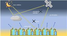
With the launch of a series of nighttime low-light remote sensing satellites, such as Defense Meteology Satellite Program (DMSP) and Suomi National Polar-orbiting Partnership (Suomi NPP), the application of low-light data in quantitative remote sensing has received increasing attention from researcher. However, there is still a lack of research summaries in the field of atmospheric remote sensing based on night-light data. Therefore, a comprehensive review of atmospheric remote sensing research based on nighttime low-light data in the past 20 years is presented. The progress of nighttime low-light atmospheric remote sensing research is summarized from three aspects: radiometric calibration low-light imager of low-light radiation transfer model and atmospheric parameters research based on low-light data. The application status and characteristics of low light data in atmospheric remote sensing research are also reviewed in this paper, which will provide a valuable reference for future in-depth application of night low-light data in atmospheric remote sensing.
Mar. 28, 2024Vol. 19 Issue 2 125 (2024)
CHEN Jiao, WANG Gen, SUI Xinxiu, XIE Feng, and ZHAO Sen
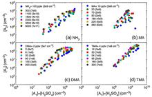
New particle formation is an important source of atmospheric aerosols and cloud condensation nuclei, which can indirectly affect global climate, air quality, ecosystem and human health. However, there are still certain limitaions in the current research and understanding of new particle formation mechanisms, especially in the understanding of key precursor species that may participate in and promote nucleation. Organic amines are abundant in the atmosphere with complex structures. As common organic bases with unique ability of acid-base neutralization, they have always attracted much attention. In view of the crucial role of organic amines in the formation of new particles, the research progress on the mechanism of organic amines promoting the formation of new particles from is reviewed in three perspectives: laboratory simulations, field observations and model calculations. Both laboratory studies and field observations have confirmed the existence of sulfuric acid-organic amine molecular clusters, and organic amines promote atmospheric nucleation more effective than ammonia at the same concentration. The model calculations also show that organic amines are more likely to react with sulfuric acid to form more stable hydrogen bond molecular clusters, thereby overcoming the free energy nucleation barrier and promoting the formation of new particles. Finally,the important role of amines in the formation of new particles is summarized, and a prospect for the future research on new particle formation is given.
Mar. 28, 2024Vol. 19 Issue 2 142 (2024)
Ling Xinfeng, HOU Can, Yang Yuanjian, HUANG Yong, and NI Ting
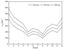
Based on the aerosol scattering coefficient, aerosol mass concentration and meteorological observation data of Shouxian National Climate Observatory Anhui, China, in 2019, the characteristics and causes of aerosol scattering over farmland area of the Huaihe River Basin is statistically analyzed, providing quantitative observation evidence for the study of aerosol radiative forcing and its impact on agricultural production over the Huaihe River Basin. It is shown that the aerosol scattering coefficient in the region has a significant seasonal variation, with the highest in winter and the lowest in summer. The daily average scattering coefficients of aerosols at three wavelengths (450, 525, 635 nm) are 329.8 ± 180.0, 270.2 ± 153.7, 214.4 ± 128.4 mm-1, respectively. The diurnal variation of aerosol scattering coefficient has a good correlation with weather factors and atmospheric diurnal variation, and the diurnal amplitude in winter is much smaller than that in the other three seasons. The annual average values of Angstrom index, backscattering ratio and aerosol mass scattering coefficient are 1.32, 0.15 and 4.83 m2/g, respectively, indicating that the aerosols over farmland area of the Huaihe River Basin are dominated by fine particles. It is also foungd that the aerosol scattering coefficient is mainly controlled by the westerly winds, and there is a high negative correlation between the scattering coefficient and visibility. In addition, the aerosol scattering coefficient of pollution days is much greater than that of clean days, and pollutants greatly affect the transmission of light radiation in the atmosphere, so the higher the pollution degree, the stronger the scattering effect of the atmosphere is.
Mar. 28, 2024Vol. 19 Issue 2 162 (2024)
YANG Dongsen, LI Wanying, CHEN Jiangyao, LIU Xinran, and ZHENG Jun
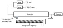
The primary particle concentration in China keeps continuously decreasing in recent years, thus, the secondary generated aerosols have become the main component of atmospheric particulate matter. As an important source of secondary aerosols, new particle formation has received increasing attention since the beginning of this century. In the chemical process of new particle formation, gaseous sulfuric acid is an extremely important gas precursor. Due to its extremely low concentration and extremely high instrument sensitivity required for detection, the accurate quantification of gaseous sulfuric acid is always the biggest difficulty in the study of new particle formation chemical process. The existing quantification method for gaseous sulfuric acid is mainly based on photochemistry methods, which uses ultra-violet radiation to photolyze water vapor to generate OH radicals and then react with excess sulfur dioxide to finally generate gaseous sulfuric acid. So, the concentration of gaseous sulfuric acid is determined by the intensity of ultra-violet light and the concentration of water vapor, in which the mainly uncertainty is the intensity of ultra-violet light due to its direct measurement highly affected by the uneven distribution of light intensity inside the reaction chamber of the calibration instrument. Besides, the scattering and absorption of background aerosols during the filed measurement can also amplify the uncertainty of the direct measurement of ultra-violet light. Therefore, this study establishes and compares two indirect measurement methods for ultra-violet radiation determination based on ozone and nitrous oxide actinometry, respectively. The results show that the main error of the ozone-based indirect measurement method comes from the absorption cross section of oxygen, with a theoretical error of > 60% and a repeated laboratory experiment error is around 12%. While the main errors of the nitrous oxide-based indirect measurement method come from the second-order rate constant kn, the uncertainties of the measurement instruments for nitrogen oxide and the mass flow controllers, with a theoretical error of < 16% and a repeated laboratory experiment error of < 1%. During the field measurement of gaseous sulfuric acid, for the indirect measurement method based on nitrous oxide, the measurement error of gaseous sulfuric acid is around 24% under the condition of calibration carried out once a day for half a month, which is close to or better than that of foreign observation results. This indicated that the nitrous oxide-based actinometry method in the quantification of ultra-violet radiation intensities has quite good accuracy and stability, and can be effectively applied to the quantitative measurement of gaseous sulfuric acid.
Mar. 28, 2024Vol. 19 Issue 2 175 (2024)
SUN Zhe, LIU Shutong, ZHANG Hong, WEI Youwen, WANG Shuibing, HONG Xingyuan, WANG Xinqi, QIAN Liming, and ZHU Sen
With the rapid development of Hefei's economy and the continuous growth of energy consumption brought about by urbanization and industrialization, the regional composite air pollution dominated by ozone (O3) and fine particulate matter (PM2.5) is becoming increasingly prominent. In order to understand the pollution characteristics and sources of volatile organic compounds (VOCs) in the atmosphere of typical industrial park in Hefei City, China, strengthened monitoring was conducted on the atmospheric quality of a certain industrial park in Hefei City from September to November 2021, and the component characteristics, concentration level, source analysis and reaction activity of VOCs were analyzed. The results show that during the monitoring period, the average value of total volume [φ(VOCs)] was (40.64 ± 8.83) × 10-9, with alkanes and oxygenated volatile organic compounds (OVOCs) accounting for a relatively high proportion of 34.2% and 26.3%, respectively. The total volatile organic compounds (TVOCs) concentration showed a typical dual-peak pattern over time throughout a day, reaching the peak value at 9:00 and 19:00, and the lowest value around 16:00-17:00. This study used PMF model to analyze the sources of VOCs, and the analysis results showed that vehicle emission (25.7%), industrial emission (24.9%), solvents volatilization (19.6%), fuel volatilization (18.6%) and biomass burning emission (11.3%) were the main sources of VOCs during the observation. Ozone generation potential (OFP) of VOCs was 233.05 μg/m3, among which OVOCs contributed the most, accounting for 36.33%.
Mar. 28, 2024Vol. 19 Issue 2 185 (2024)
JIA Pengcheng, WANG Jianlin, GU Jie, and CAO Yang
Based on the hourly ozone (O3) concentration monitoring data of the national control points in Nantong City from 2017 to 2020 and the hourly meteorological data of the national basic meteorological station in Nantong City, China, during the same period, the interannual variation, monthly variation, daily variation of ozone pollution changes in Nantong City were analyzed, as well as the relationship between O3 pollution characteristics and meteorological factors. The results show that: (1) The seasonal variation amplitude of ozone concentration is summer > spring > autumn > winter, and diurnal variation of O3 shows a unimodal trend, with the lowest value usually occuring during 06:00–07:00 am and the highest value around 15:00. (2) The O3 concentration is positively correlated with temperature, and negatively correlated with relative humidity. When the temperature is greater than 20 °C, the relative humidity is between 30% and 50 %, and the wind speed is between 0 m/s and 4 m/s, the O3 concentration is often high, and excessive conditions are likely to occur.
Mar. 28, 2024Vol. 19 Issue 2 199 (2024)

YE Xiaoxin, XU Bo, ZHANG Yi, QIAN Chenchen, and SHAO Wei
The typical dust pollution process in Taixing City, Jiangsu, China, in the spring 2021 was comprehensively analyzed using the monitoring data of particulate matter from local air quality automatic monitoring station and atmospheric particulate matter monitoring lidar, as well as the meteorological data, and HYSPLIT air mass backward trajectory model. The results show that: 1) At the initial stage of dust pollution, the concentration of PM10 increases significantly, and when the pollution is serious, PM2.5/PM10 decreases to about 0.2. 2) During the influence period of dust pollution, the concentration of particulate matter in Taixing City shows a bimodal distribution, while the reasons for the secondary peak of the two dust polluion events are different, with the secondary peak in the evening of March 30 being related to dust deposition, and that in the morning of May 8 being related to dust backflow caused by the weather system. 3) Combined with the lidar inversion results, it can be seen that in the two dust pollution processes, the dust transport height is generally below 2 km, and the thickness is greater than 1 km; 4) According to air mass backward trajectory analysis, dust transport in Taixing City is mainly from northwest and north, and the potential pollution sources are mainly the imported pollution from Inner Mongolia, Anhui, Henan, Hebei and Hubei. By understanding the spatial and temporal distribution and evolution process of spring dust pollution in Taizhou City, it provides a certain scientific basis for improving the situation of spring particulate matter pollution in the area.
Mar. 28, 2024Vol. 19 Issue 2 210 (2024)
WANG Xiaodi, WANG Xianhua, SHI Hailiang, YE Hanhan, LI Chao, AN Yuan, and SUN Erchang
Solar-induced chlorophyll fluorescence can indicate the physiological state of vegetation directly. As vegetation is an important sink, it is of great significance of using greenhouse gas satellite remote sensing data to retrieve vegetation chlorophyll fluorescence for analyzing the sources and sinks of atmospheric greenhouse gases. Based on the GF-5 satellite "Atmospheric Major Greenhouse Gas Monitor (GMI)" and U.S. OCO-2 remote sensing data, the retrieval of chlorophyll fluorescence for the GMI satellite remote sensing data of Amazon forest, Sahara desert and African grassland regions in January and July 2019 is conducted using the oxygen absorption line fitting method, and the results are compared with OCO-2 data fluorescence products. The retrieval results show that the GMI data presents a good result in the retrieval of chlorophyll fluorescence intensity compared with U.S. OCO-2 data in two research periods of the three research areas.
Mar. 28, 2024Vol. 19 Issue 2 221 (2024)
PU Lilan, and ZHANG Xianyun
In order to fully exploit the environmental monitoring capability of domestic Gaofen-4 satellite (GF-4), overcome the complexity of retrieving aerosol optical depth (AOD) based on look-up table method, make up for the lack of aerosol monitoring station in Guiyang City, China, and improve spatial and temporal resolution of MODIS AOD products, the AOD inversion model for Guiyang was constructed based on LightGBM algorithm using the elevation data of the study area and the surface reflectance, solar zenith angle, satellite zenith angle, relative azimuth angle and normalized different vegetation index extracted from the data of GF-4 panchromatic multispectral sensor (PMS) as the feature variables, and taking MODIS aerosol products as the label. The research results show that the model can achieve high precision AOD intelligent inversion based on GF-4 PMS single-phase remote sensing data, greatly simplify the AOD inversion steps, and has high modeling accuracy (with mean absolute error EMA, root mean square error ERMS and coefficient of determination R2 of 0.042, 0.057, and 0.751, respectively) and prediction accuracy (with EMA and ERMS of 0.077 and 0.086 respectively in urban area, and EMA and ERMS of 0.094 and 0.101 respectively in non-urban area). In addition, it is shown that the predicted AOD with the proposed inversion model and MODIS AOD have a similar variation trend, and the Pearson correlation coefficient of them is 0.697.
Mar. 28, 2024Vol. 19 Issue 2 232 (2024)
LI Chaonan, and XU Yannan
Based on Landsat 8 OLI-TIRS remote sensing imagery, the surface temperature data of Nanjing City, China, was inverted using the radiation equation algorithm, the spatial and temporal variability of the thermal environmental landscape in Nanjing during 2013-2021 is revealed in terms of quantity and rate, and the spatial evolution of the thermal environmental landscape is further revealed using kernel density analysis and spatial centroid migration trajectories. In addtion the driving mechanisms of the thermal environmental landscape from 2013 to 2021 was explored with the help of the PLUS model.The results indicate that: (1) The mesothermal landscape dominated the study area, from 2013 to 2021, and the strongest change in the thermal environmental landscape from 2017 to 2021, with a comprehensive thermal environmental dynamic degree of 23.94%. (2) During 2013-2021, the density core of the low temperature zone was mainly located in water and woodland, with more pronounced clustering characteristics in the north.The sub low temperature zone was characterized by a denser and more fragmented distribution in northern and southern regions.The medium temperature zone had a "less in the middle and more around" distribution pattern.The sub high temperature zone landscapes showed a trend of multi-core growth, and the high temperature zone had the most significant landscape clustering characteristics, mainly distruibuted on both sides of the Yangtze River and in the centre of urban areas. (3) Generally, the low temperature zone has the fastest rate of centroid migration with an overall movement of 21.30 km to wards the northeast.The rate of centroid migration of the sub low temperature zone changed from slow to fast, during the period, first moving 9.52 km to the northwest and then 17.881 km to the southeast.The centroids of the high temperature zone, sub high temperature zone and medium temperature zone were shifted to the southwest as a whole, with distance of 19.99, 4.77 and 4.04 km respectively. (4) In terms of the driving factors for the expansion of the different thermal environmental landscapes, the expansion of the low temperature zone, sub low temperature zone and medium temperature zone was mainly driven by the elevation, while the main drivers for the expansion of the sub high temperature zone and the high temperature zone were distance from residential buildings and distance from factories.This study provides an important reference for strengthening the monitoring of Nanjing's surface thermal environment and promoting the sustainable development of the urban ecology.
Mar. 28, 2024Vol. 19 Issue 2 243 (2024)
ZHAO Zihao, LU Meina, XU Zhilong, WU Yang, LIU Jingyan, SONG Maoxin, and LUO Donggen
Aiming at the characteristics of strong real-time, high synchronization and high data rate of the focusing and leveling system based on the linear Charge-coupled Device (CCD) imaging principle, an optical fiber communication test system based on the serial RapidIO bus protocol was designed. The system uses Field-Programmable Gate Array (FPGA) as the control core, optical fiber as the transmission medium, and completes the command control and image data transmission during the performance verification process of the focusing and leveling system through the serial RapidIO bus protocol. The SRIO interface design based on dual First Input First Output (FIFO) buffers makes the test system highly versatile and practical. The test results show that the data transmission rate of the optical fiber interface of the system reaches 440 MB/s, which can meet the requirements of data transmission rate and correctness for the performance verification of the focusing and leveling system.
Mar. 28, 2024Vol. 19 Issue 2 257 (2024)
© Copyright 2018-2021 | Chinese Laser Press.
All Rights Reserved 沪ICP备15018463号-20