


Please enter the answer below before you can view the full text.
6-1=
The Yellow River Basin as a whole is in the mid- to late stage of industrial transformation and the rapid development stage of the regional economy. It is in general in the “siphon effect” stage where the agglomeration function is stronger than the diffusion effect, and in the period of intense competition in intraregional development. Medium/high-speed economic growth of high-quality is a prerequisite for the modernization and sustainable development of the Yellow River Basin. Based on a general analysis of the connotation and change of theories of high-quality development in the basin (region), this article explores the basic conditions and core strategies of high-quality development in the Yellow River Basin. The basic conditions of high-quality development are the local diversity and vulnerability of agricultural development, the loose nature of the economic links in the river basin, constraints from the stage of economic development and its internal differences, and lack of momentum of external investment and industrial transfer, among others. These particularities determine that the high-quality development of the river basin must manifest itself in a long-term, diverse, competitive, cooperative, and regional orientation. Therefore, the high-quality development of the Yellow River Basin needs to explore a core strategy of “overtaking by curves”: (1) With the development of smart society and globalization, the region should seek high-quality growth, that is, continue to explore new industrialization models in the region that are suitable for national needs and local characteristics, and build localized industrial clusters/chain to enhance comprehensive competitiveness; (2) Explore new models of synergy under the premise of homogeneity, plan river basin coordination and improve coordination mechanisms, and seek a new urbanization model of localization, including localized population urbanization strategy and urban-rural coordination model, especially the continued migration of rural population to river valleys/basins, plains, and towns based on land transfer. Improve labor productivity, paying attention to water resources and infrastructure construction, and so on; (3) Implement the “center breakthrough” system, seek the spatial reconstruction of the drainage basin led by the centers, promote the healthy development of central cities and urban agglomerations, and promote high-quality development. In general, the high-quality development of the Yellow River Basin is a long-term exploration process of at least 20-30 years.
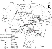
In accordance with the national strategy of “ecological protection and high quality development of the Yellow River Basin,” this article discussed the development of the Yellow River Delta. First, regional territorial structure was studied. According to the regional characteristics and the development strategies, the breakthrough point of further development is land-sea coordination. Second, territorial function zoning was conducted to divide the research area into different functional zones for development and protection. The functional zones connect land and sea across the coastline, which is convenient for implementation and management of coordination. Third, with respect to land and sea coordination and interconnected development, this study examined several key issues. (1) Harbor system: Take the ports as nodes to link land transportation and sea shipping, revitalize the area with ports, improve the channel, and expand the hinterland. (2) Fishery: Develop the zonal layout of marine fishery, put forward high efficiency ecological fishery models of sea water and fresh water, and land-sea coordination with a wider scope and meaning. (3) Ecology and environment: Include land-sea integrated ecological protection, land and sea environmental co-governance, as well as coastal protection and disaster risk reduction systems. As an integral part of the overall system of the Yellow River Basin, the development of the Yellow River Delta should not only be linked with basin-wide development, but also adapt to local conditions in order to achieve ecological protection and high-quality sustainable development through land and sea coordination.
The world’s major river basins witnessed the history of the development of human economic division of labor. Today’s global environmental changes and economic integration have a profound impact on the relationship between the opening-up of river basin economic systems and their sustainable development. Through a regional economic geography analysis guided by modern systems science methods, this study conducted case descriptions and indicator comparisons of selected international river basins in Asia, Europe, North and South America, and Africa. The findings show that the opening-up factors have a complex effect on the operational parameters of the economic systems of the river basins, which leads to the diversification of the pattern and development path of the economic systems of the river basins. The global river basin economic system form the benign teraction between opening-up and sustainable development through the combined action of independent opening-up, innovation, coordination, adaption and sharing, which can provide the Yellow River Basin with experiences for realizing high- quality sustainable.
The upstream area of the Yellow River Basin in Qinghai Province is an important component of the national ecological barrier and the “water tower” of China, and a priority area for ecological protection. In this article, a set of relevant studies on land use pattern and process in this area over the past 40 years were reviewed, and the article comprehensively analyzed the current status, changes, and effects of land use and made policy recommendations. We found that: (1) There is a relatively stable land use pattern with grassland as the absolute dominant land-use type in the upstream area of the Yellow River Basin. An important turning point in land use occurred around 2000. Before then, ecological land such as grasslands, woodlands, and wetlands decreased and resulted in adverse effects such as land degradation, soil erosion, and desertification in the region. After 2000, ecological land and vegetation index increased, the ecosystem gradually changed to a healthier direction, and the carbon sink function is enhanced. (2) The implementation of a series of ecological projects and climate change make land use and its effects extremely complex. On the whole, the total area and degree of land degradation decreased to some extent, with grazing resources and livestock population largely balanced. The cultivated land area of the Yellow River-Huangshui River valley in the east has been decreasing, and agricultural intensification has increased significantly with the planting structure gradually optimized. Local deterioration is still severe, especially that soil erosion intensified in the freezing-thawing zone in alpine regions. (3) In the future, it is necessary to further research on the mechanism of ecological effects of land use, the contribution of environmental effects of ecological engineering and natural factors, and ecological service value to better understand the human-environment relationship in this study area.
The spatiotemporal pattern of land use is an important representation of the interaction between human and nature. Study on the spatial-temporal pattern of land use and its driving factors in the Yellow River Basin and to clarify land-use conversion as well as the spatial-temporal variation of cultivated land, ecological land and urban-rural construction land, which can provide some reference for the planning and implementation of the national strategy of ecological protection and high-quality development of the Yellow River Basin. Based on the transfer matrix of land use types and spatial autocorrelation, the study explored the land use in the Yellow River Basin provinces from 1970 to 2015 by using land use data of seven periods from multiple scales of city cluster, province, city, and county. The results show that: (1) The proportion of ecological land and arable land in the Yellow River Basin is 79.04% and 18.64% respectively on average, indicating that ecological protection and food production are two main functions there; (2) The urban-rural construction land proportion increases year by year, and urban agglomeration region is the main space of construction land expansion; (3) Moran’s I of arable, ecological, urban-rural construction land of the Yellow River Basin provinces was more than 0.75 in different years and showed a strong positive spatial agglomeration effect and a pattern of concave type distribution ; (4) The expansion of urban-rural construction land is at the expense of arable land, and at the same time, part of rural land is gradually transformed into urban land, and the imbalance between human and land is increasingly prominent. (5) Population size and economic development are the core factors to promote land use change, and the performance of different spatial driving factors is inconsistent. There will not appear large-scale expansion of urban and rural construction land with the economic development in Shandong and Henan provinces located in the lower reaches of the Yellow River.
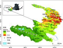
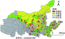
Clarifying the spatial and temporal change characteristics of regional population is helpful for promoting high-quality population agglomeration. Based on the multi-source data and by using the population gravity center method, standard deviation ellipse, population structure index, population-land distribution consistency coefficient, spatial autocorrelation analysis, and GIS spatial statistical analysis, this study analyzed the spatial-temporal characteristics of population distribution in the Lanzhou-Xining (Lan-Xi) urban agglomeration at different scales (urban agglomeration, county, township (town), and grid). The results show that: (1) The scale of population of the Lan-Xi urban agglomeration is small, population mobility is limited, urbanization level is very low, and the growth rates of population and urbanization is very slow. (2) During the study period of 2000-2017, the population gravity center moved westward slightly, and the population showed a northwest-southeast distribution pattern and formatted a core-periphery spatial structure. Lanzhou, Xining, and Linxia are the three population concentration centers, and Lanzhou has the “siphon effect” of population concentration. The population distribution is higher in the central and southern parts and lower in the northern part of Gansu Province, while in Qinghai Province the population distribution decreases outward concentrically from Xining. (3) Altitude is the main topographic factor which influences the vertical distribution pattern of population. The population is mainly concentrated in the valley basins with an altitude of less than 2400 m, indicating that the vertical gradient effect and basin agglomeration are obvious. The spatial-temporal characteristics of population distribution were analyzed from different perspectives and at different scales, so that the research results and corresponding countermeasures and recommendations can provide a scientific basis for promoting the spatial layout optimization of population distribution.
In order to analyze the coastal erosion and sediment dynamics of the Yellow River Delta and their responses to the runoff-sediment flux since 1976, satellite images of Landsat from 1976 to 2018 were acquired and used in this study. After the extraction of coastline and Yellow River Delta area, we analyzed the erosion and sediment dynamics of the whole area, the northern coast, and the estuary respectively. Then, the inter-annual and intra-annual variations of runoff and sediment were analyzed. At last, the relationship between coastal erosion and sediment dynamics and runoff and sediment flux in the estuary was discussed. The results show that: (1) The land area of the Yellow River Delta has increased over the past 43 years. Before 1996, the area of the estuary increased significantly, with an annual average increase of about 17 km 2. Then the landmaking process gradually slowed down. (2) After water-sediment regulation, the rate of annual sedimentation decreased from 31 million t to 0.7 million t, the maximum decreased by 79.7%, and sediment decreased by 74.8% during the flood season. (3) The continuous decrease of sediment directly affects the epeirogenic process of the current flow path of the estuary, while the dynamic constraints of the ocean are increasing. Correlation between the cumulative epeirogenic area of the estuary and annual sediment decreased from 0.93 in 1976-1993 to 0.39 after 2002. On the whole, although the water-sediment regulation has maintained the growth of delta land area, the land area of the delta tends to decrease in the future.
The Kuye River catchment is located in the soft sandstone area of the middle Yellow River where the ecological environment is extremely vulnerable. It is one of the principal sources of coarse sediment in the middle reaches of the Yellow River. The runoff and sediment load of the river have been changing considerably in recent decades. Therefore, it is of great significance for improving the catchment management of the middle Yellow River to explore the impacts of climate change and human activities on runoff and sediment discharge in the Kuye River catchment. In order to reveal the long-term variations of runoff and sediment discharge of the Kuye River, this study analyzed the runoff and sediment discharge series from 1955 to 2015 using non-parametric Mann-Kendall test and three kinds of abrupt change test, and estimated the contribution rates of climate change and human activities, respectively, using elasticity method based on the water balance model and double mass curve method. The results show that annual runoff and sediment discharge had a significant decreasing trend and the jump points occurred in 1996. The relationship between runoff and sediment discharge has changed significantly since 2012. Compared with the reference period (T1: 1955-1996), the contribution rates of climate change and human activities to annual runoff reduction are 18.53% and 81.47%, respectively. The contribution rates of climate change and human activities to annual sediment reduction are 3.59% and 96.41%, respectively. Human activities, mainly vegetation restoration and coal mining, are the most important reasons that caused the reduction of annual runoff and sediment load in the Kuye River. Considering that intended and unintended human interferences in the Kuye River catchment have greatly reduced not only the sediment yield but also the inadequate water resource, it is a question of how to achieve ecological protection and high quality development by planning future soil and water conservation projects and adjusting the industrial structure in the context of global climate change with reference to previous governance effects.
The source region of the Yellow River is an important ecological barrier and grass-based livestock husbandry area in China. It plays a significant role in ensuring the national ecological security and improving local pastoralists’ livelihood. Since the 1970s, alpine grasslands in this region have been degraded to varying degrees under the combined influences of climate change and human activity, which has posed certain threat for local grass-based livestock husbandry, regional ecological security, and the sustainable development of the middle and lower reaches of the Yellow River Basin. Since 2000 the state has implemented a series of ecological protection and construction projects to curb alpine grassland degradation in the source region of the Yellow River. As expected the grassland ecological environment in this area has been gradually improved since project implementation, but the grassland degradation trend has not been effectively curbed. In order to promote the ecological protection and economic development in the source region of the Yellow River, we systematically reviewed the research, demonstration and application works in relevant fields, and summarized a regional suitable technology system for grassland ecological protection and grass-based livestock husbandry development, then established a regional coupling development model based on the optimal allocation of grass-livestock resource. Additionally, we analyzed the application effects of related conservation and development technologies based on our case studies, also we proposed suggestions for the management of degraded alpine grassland and the development of ecological grass-based livestock husbandry in this region. The paper offers a certain enlightenment to promote the grassland ecological protection and high-quality development in the source area of the Yellow River.
Comprehensive monitoring and assessment of the ecological changes in the Yellow River Delta (YRD) is fundamental of properly understanding ecological conditions of the delta region and strengthening ecology and environment protection and supervision. Based on multi-source satellite remote sensing and ground observation data, this study monitored the changes of ecological space and vegetation growth in the High Efficiency Eco-economic Zone of the Yellow River Delta (HEEZ-YRD) over the past 30 years, identified the basic characteristics of regional ecological status, and quantitatively analyzed changes of regional wetland, coastline, water and sediment resources. Then, combining with a series of ecological protection and restoration measures taken by the state and local governments, this article discussed the regional protection effectiveness, identified the main ecological problems in the YRD, and put forward countermeasures and suggestions. The results show that from 1990 to 2018, occupied by urban and agricultural space, the reduction of ecological spatial area in the past 30 years was about 7.6% of that in 1990, and the growth trend of vegetation around the coastal and urban agglomeration areas decreased in the HEEZ-YRD. Artificial wetland that mainly composed by ponds increased by 18.1%, artificial shoreline increased by 27.1%, and the natural wetland and shoreline resources lost significantly. The speed of ecological space being occupied has slowed between 2010 and 2018, and the positive effects of ecological protection planning and engineering measures have gradually emerged. The growth rate of the artificial wetland area and the artificial shoreline length has slowed significantly, and the regional ecological protection effect has gradually shown. Since the 1950s, water and sediment conditions of the Yellow River have changed dramatically, and the water and sediment resources entering the YRD have gradually reduced. The ecological water replenishment demand of the original wetland and the threat of erosion and regression faced by new wetland are still severe. Therefore, increasing protection and restoration of regional wetland resources, optimizing the spatial distribution planning of ecological protection, and strengthening the control of ecological space are the necessary means to improving the biodiversity of the YRD and promoting the high-quality development for the region.
As the global value chain (GVC) plays an increasingly more important role in the global economy and trade, the impact of GVC on resources and the environment has attracted increasingly greater attention. In order to explore the impact of GVC position on carbon emissions, we focused on major global economies and combined GVC index with the Carbon Dioxide Information Analysis Center (CDIAC) carbon emission database to form panel data for analyzing the impact of GVC position on carbon emissions, based on the environmental Kuznets curve. A structural equation model was used to perform endogenous analysis and robustness test. The empirical results show that, similar to the environmental Kuznets curve, the impact of GVC position on carbon emissions showed an inverted U-shaped relationship. Further mechanism analysis found that improved GVC position can reduce carbon emissions through increased use of green energies. Using cross-item analysis, improved GVC position can help R&D investment and innovation and entrepreneurship levels, which in turn reduces carbon emissions. Meanwhile, the increase in R&D investment levels and the improvement of innovation and entrepreneurship can improve the status of GVC positions, helping the economy to cross the turning point faster and shift to a more low-carbon and environmentally friendly development model. The research conclusions may enrich the application of global value chain theory in the environment field and provide new ideas for exploring the theory of carbon emission reduction.
Substituting fossil fuels with bioenergy is one of the most promising options for energy transition in China, and abundant forest biomass plays an important role in this process. In this study, the mitigation effects and economic benefits from substituting wood pellets for coal in heat and power generation in China were investigated, based on a life-cycle assessment and economic contribution analysis using the system boundaries defined for the two energy systems in terms of greenhouse gas emissions and economic cost. The results suggest that: (1) When wood-based pellet replaces coal in heat and power generation, the life cycle energy consumption per unit of energy produced decreases (0.01-0.176 MJ), and the greenhouse gas emissions are significantly reduced if wood pellets are assumed to be carbon neutral; (2) Based on the average market prices of wood pellets and coal, the cost per unit heat or electricity generation by burning wood pellets is higher than that of coal (16.06-34.16 Yuan), because the energy used in wood pellets production is more costly; (3) The sensitivity analysis suggests that energy conversion efficiency, fuel energy content, and fuel price are the most important factors that affect the effectiveness of energy substitution; and reducing energy consumption and the overall cost for producing wood pellets is most effective for reducing the substitution cost and creating a win-win situation for both climate mitigation and economic development. The development and utilization of forest biomass play an important role in China’s energy structure transformation. This study can inform policy development from the aspects of emission reduction under carbon neutrality assumption, source of biomass, emission reduction efficiency, and financial subsidies.
Under the land-based development mode, local governments dominate land allocation and adopt the strategy of “low price for industrial land, high price for commercial and residential land” in land transfer, which has achieved the goal of industrial structure upgrading and economic growth in China. However, during China’s economic transition, the land supply strategy that once promoted the upgrading of industrial structure may no longer meet the development requirements of the new era. Through the theoretical analysis of governments’ land supply logic and the effects of differential pricing strategy in land supply on the upgrading of industrial structure at different economic development levels, this study came up with hypotheses and then based on the threshold regression model made an empirical test by using the data of land supply in 277 cities of China from 2011 to 2016. The results show that the influence of land price difference on the upgrading of industrial structure is non-linear due to different economic development levels. The effect of the differential pricing strategy in land supply on the upgrading of industrial structure changes from positive to negative with the improvement of economic development level, and the mismatch of land supply structure caused by inclined supply of commercial and residential land significantly restrains the upgrading of industrial structure, whereas enhancing the marketization of land transfer and lowering the dependence on land finance will promote it. Therefore it is suggested that local governments should fully consider the socioeconomic environment in which they operate when formulating land supply strategies, and identify the limitations of their intervention in the economy, pay attention to cultivating more effective markets, improve the degree of land marketization, and avoid excessive reliance on land finance when participating in land market activities.
Traditional ecological suitability evaluation methods based on current land use status have their limitation in supporting development decision for urban construction land in rapid urban-expansion regions. This article first proposed the concept and method of potential ecological suitability evaluation of urban construction land. The method highlights the predicted future urban land-use distribution that is regarded as an important factor in the ecological suitability evaluation framework, and generates the evaluation result that is suitable for future planning and decision making of urban construction land. This study took Baoshan District, Shanghai Municipality, China as the study area and presented the spatial distribution of ecological suitability of urban construction land in 2050 under the background of urban expansion. The result was compared with the traditional ecological suitability evaluation results. The comparison revealed that potential ecological suitability evaluation can effectively reduce the high overlaps of the lands unsuitable or moderately unsuitable to be developed and the future urban buildup areas (reducing the overlap from 9.74% and 22.7% to 0.0% and 14.5%). It can match the urban development boundary planning and ecological space planning better and highlights the key protected ecological regions in future development. The case study proved the soundness and effectiveness of the new evaluation method, which can provide better decision supporting for ecological urban planning under the background of urban expansion.
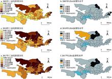
Function of renewable resource-based cities is a main indicator of industrial structure, and the transformation of industrial structure causes the evolution of the functions of such cities. Using the method of locational remoteness and entropy weight TOPSIS, the functional heterogeneity characteristics and evolution paths of China’s renewable resource-based cities from 2005 to 2016 were studied. The promoting role of industrial structures in the evolution of their urban functions was also discussed. The results show that: (1) The functions of the studied cities have continued to improve, but the co-evolution pattern of each sub-function has not yet been formed. However, the resource exploitation function has declined significantly. The industrial manufacturing and science and education innovation functions have continuously increased. In particular, there are significant differences in the functions of industrial manufacturing and concentrated radiation. Among these cities, the mature and developing cities are characterized both by strong industrial manufacturing and weak resource exploitation, while cities at the initial stage of development have strong ecological security functions and clear differences among sub-functions. (2) The functions of the studied cities have diversified and mainly are based on ecological security-industrial manufacturing overall. However, the evolutionary path is heterogeneous. The mature cities are characterized by multi-dimensional balanced change. The developing cities are characterized by dual functions of resource exploitation and concentrated radiation. The cities at the initial stage of development show an unbalanced and multi-functional dominant change trend. (3) The differences in the functional evolution paths of China’s renewable resource-based cities are driven by the heterogeneity of industrial structure transformation. For China’s renewable resource-based cities, the higher the level of industrial structure’s diversification, advancement, greening, and service, the more comprehensive its functions will be. The evolution of city functions also affects the speed of industrial structure transformation. The degree of advanced industrial structure in cities with strong comprehensive functions is higher, and vice versa.
Global sustainable development and China’s ecological civilization education put forward higher requirements for stimulating public environmental awareness and guiding public’s environmentally responsible behavior, especially for the urban population. Beijing took the lead in introducing the concept of forest experience education, giving full play to the forest ecosystem’s educational function and carrying out rich and diversified forest experience educational activities. Based on the flow theory and literature, this study constructed a conceptual model of the impact of forest experience educational activities on guiding the environmentally responsible behavior of the public. Taking Beijing as an example, it surveyed 676 participants and used the structural equation modeling method to verify the influencing mechanism of participation motivation (before the activities) and personal experience (during the activities) on the environmentally responsible behaviors (after the activities). The results of the study indicate that the impact of experiences during such activities on guiding the public’s environmentally responsible behavior is significant and positive, and it is a complete mediator between participation motivation and environmentally responsible behavior. This conclusion indicates the effectiveness and necessity of forest experience educational activities. It provides some theoretical support and practical reference for further enhancing the effect of those activities in Beijing and promoting similar activities in other areas of China.