


 View fulltext

2020
Volume: 49 Issue 11
31 Article(s)

Chunyu Yue, Yongchao Zheng, Yanqiu Xing, Yong Pang, Shiming Li, Longtao Cai, and Hongyan He
Forestry observation is an important direction of the development of space-borne LiDAR. So far, foreign space laser remote sensing payloads have been developed. The experimental LiDAR carried by Chinese ZY-3(02) satellite is a big breakthrough in earth observation of space-borne LiDAR in China, and the oncoming multi-beam LiDAR of Chinese CE-1 satellite will be applied to forestry remote sensing. The vertical structure of forest was acquired by ICESAT-1/GLAS waveform, while point cloud of forest was obtained by ICESAT-2/ATLAS photons. The space-borne LiDAR forestry remote sensing gradually entered the practical stage, beyond the experimental stage. During this period, technical system, configuration, and techniques had improved. In this paper, the applications and technique developments of main forestry remote sensing space-borne LiDAR in use were analyzed, and the characteristics and development trend were summarized, based on the study of detection principle, technical system, observation condition, etc. Space-borne forestry observation LiDAR payloads should be designed according to scientific mission, application requirements and technical characteristics, using the advantages of space-borne LiDAR, and based on which the development trend and research focus of space-borne forestry observation technology and application were prospected.
Nov. 25, 2020Vol. 49 Issue 11 20200235 (2020)
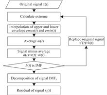
Xiangfeng Liu, Genghua Huang, Zhijie Zhang, Fengxiang Wang, and Rong Shu
The complex full waveforms from laser altimetry, mixed with high noise, are usually reflected by the object with multiple height elevations. To accurately analyze the decomposition, vertical structure and characteristic parameters from these waveforms, a noise reduction method based on empirical mode decomposition (EMD) was investigated and tested with the full waveform of nonlinear and nonstationary signals obtained by GaoFen-7 space-borne laser altimetry. The reconstruction of an effective waveform signal was implemented through reverse superimposition of its intrinsic mode functions (IMFs) and the residual. And then different selection methods for these IMFs were compared, such as removed high frequency, threshold, wavelet and detrended fluctuation analysis (DFA). The results show that EMD-DFA1 and EMD-1 IMF have a higher noise reduction effect on these full waveforms, followed by EMD-Wavelet and EMD-Threshold. Finally, EMD-DFA1 was performed on the full waveforms with single peak, mixed peaks and multiple peaks. And the results show that EMD-DFA1 does well adaptability.
Nov. 25, 2020Vol. 49 Issue 11 20200261 (2020)
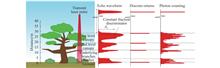
Yuanyong Deng, Weiqun Gan, Yihua Yan, Shangbin Yang, Xianyong Bai, Junfeng Hou, and Jie Chen
Magnetic field is the most important observed parameter in modern solar physics. The observation and research related to the solar magnetic field are always the front and hot topic in solar and space physics. The development history, current status, and the difficulties in the measurement of solar magnetic field were briefly reviewed. The progress made by Chinese solar community was outlined too. Depending on these reviews, what Chinese solar magnetic field should do in the future international competition was discussed. Based on the advantages of space observation, it is believed that deep-space exploration will play a decisive role in the breakthrough of major scientific problems related to the solar magnetic field.
Nov. 25, 2020Vol. 49 Issue 11 20200278 (2020)
Huabing Du, Ao Sun, Wanli Shang, Lifei Hou, Xingsen Che, Yimeng Yang, and Guohong Yang
Flat response X-ray diodes have been widely used in large-scale laser devices at home and abroad for the measurement of angularly distributed X-ray radiation flux. In practical experiments, flat-response X-ray diodes measure radiation flux images that have a step change in a shaped pulse-driven radiation source. In order to ensure a good signal-to-noise ratio, a single signal will be connected to multiple channels of the oscilloscope, and then the signals of different channels will be processed, and the final image with good signal-to-noise ratio will be stitched. The research in this paper mainly introduced this data processing method and gave theoretical calculations. At the same time, a theoretical approximation and numerical simulation of a deviation in the calculation of the low temperature radiation flow reduction were made, and the relative uncertainty of the deviation was obtained. Coupled with the uncertainty of all factors, the curve of the overall uncertainty of the flat-response X-ray diode as a function of the radiation temperature was obtained, which realized precise diagnosis and completed the experimental needs for diagnosis.
Nov. 25, 2020Vol. 49 Issue 11 20200181 (2020)

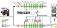
Jiachuan Sheng, Yaqi Chen, Jun Wang, and Yahong Han
Automatically analyzing the sentiment of natural images plays a vital role in analyzing user needs and network public opinion monitoring. However, the training processes of deep learning-based classification algorithms are too difficult to be controlled, and their classification results are always lack of interpretation. A deep learning structure optimization algorithm with human cognition was proposed to classify image sentiment. Firstly, the emotional features extracted were visualized by the convolutional neural networks. Then, the network structure was optimized by combining with human’s subjective perception of image emotion, and the network structure was driven by human knowledge to focus on the apparent features of emotional information. Finally, the parameters of the rebuilt network were fine-tuned to make it more suitable for images sentiment classification task. Contrastive experiments on the Twitter dataset systematically demonstrate that the proposed algorithm achieves 88.1% classification accuracy, which has superior performance than other methods. Ablation experiments confirm that our network optimization improves the classification effect by 8.1%. Besides, the process and reason were intuitively explained for the model operation through class activation maps, spatial location visualization and neuron group visualization. The visualization experimental results further demonstrate the ability of proposed algorithm to recognize the sentiment of natural images.
Nov. 25, 2020Vol. 49 Issue 11 20200269 (2020)
Lei Zhang, Shuai Zhu, Tianyu Liu, and Yuehuan Wang
To cope with the problem of numerous accompanied interference in the field of target detection and tracking in space, a fast detection and tracking method for targets in space based on dense multi-target motion grouping was proposed. Firstly, within the range allowed by the sensor resolution, the sparse optical flow was adopted to extract the motion information of the individual in the group, and then the generating function regularization was used to integrate the similarity between the motion paths. With the idea of “collective merging”, collective motions were detected from dense random motion, so that the group targets can be divided into several sparse groups with similar motion patterns in space. Finally, a graph model based on the topological relationship among sparse groups was constructed to filter out potential targets for which the false alarm was suppressed by inter-frame correlation. Simulation and experiment results show that the proposed method has good robustness and real-time performance for different group targets distribution in space.
Nov. 25, 2020Vol. 49 Issue 11 20200284 (2020)

Pufan Zhao, Yue Ma, Yu Wu, Shizhe Yu, and Song Li
On-orbit calibration technique is a key factor which affects the photon geolocation accuracy of spaceborne LiDAR. The current status of spaceborne LiDAR on-orbit calibration technique was introduced, and the characteristics of various spaceborne LiDAR on-orbit calibration technique were analyzed. Aiming at the characteristics of the photon counting mode spaceborne LiDAR, a new on-orbit calibration method based on the natural surface was derived, simulated point cloud was used to verify the correctness of the calibration algorithm, and a cross validation experiment was made with the surface data of the Antarctic McMudro Dry Valleys and China Lianyungang areas and ICESat-2 point cloud data, the experimental results show that the plane offset between the point cloud calibrated by proposed algorithm and point cloud provided by National Aeronautics and Space Administration is about 3 m, elevation offset is in centimeter scale. The differences between the point cloud calibrated by the algorithm and the point cloud provided by National Aeronautics and Space Administration were also compared by using the feature points of artificial construction on the ground. Finally, the accuracy of the on-orbit calibration method based on natural surface and the influence of the calibration field topography were discussed.
Nov. 25, 2020Vol. 49 Issue 11 20200214 (2020)
Xiaoming Gao, Guoyuan Li, Jinquan Guo, Sida Ouyang, and Wenfeng Fan
Antarctica, Arctic and Qinghai Tibet Plateau are known as the three poles of the earth. The " tri-polar" regions, which are undergoing great changes, are not only the key areas affecting the study of global climate change, but also the important strategic special areas to protect national security interests. Compared with other polar satellites, it has obvious advantages in obtaining high-precision 3D earth surface information. In order to meet the needs of remote sensing observation and research in the "tri-polar" region under the new situation, based on the laser altimetry satellite, the status of the existing laser altimetry satellites in polar observation was summarized. The observation requirements in polar region were analyzed, and the observable elements of laser altimetry satellite in polar region were discussed. Moreover, the development of laser altimetry satellite for polar observation in China was proposed, the preliminary ideas and prospects for the future construction of polar remote sensing satellite observation system were discussed.
Nov. 25, 2020Vol. 49 Issue 11 20200233 (2020)
Guoyuan Li, Jiaqi Yao, Yiming Zhao, Zhengqiang Li, Xu Li, and Hongzhao Tang
Laser altimetry satellite can obtain the surface elevation information of sub-meter or even centimeter-level in a wide range, but it is inevitably affected by the scattering caused by particles such as clouds and aerosols. The laser ranging and final height measurement errors caused by forward scattering of the cloud or fog can not be ignored. In this paper, the atmospheric scattering error correction technology of laser altimetry satellite was systematically reviewed, and the satellite laser altimeter system parameters, atmospheric detection and scattering correction algorithm at home and abroad were introduced. Different from the Monte Carlo simulation correction method theory, an atmospheric scattering correction algorithm based on exponential function model was proposed. The data of GLAS (Geo-science Laser Altimeter System) on the ICESat (Ice, Cloud and land Elevation Satellite) in Qinghai Lake and other regions was selected for the experiment, and the experimental results show that the algorithm can effectively improve the accuracy of the altimetry data affected by atmospheric scattering when the optical thickness is less than 2, and the data availability rate can be improved by about 9%. The algorithm is easier to realize operation application. Finally, according to the necessity of synchronous detection of atmospheric parameters, some suggestions for atmospheric scattering correction of domestic laser altimetry satellites were put forward in combination with onboard atmospheric parameter detection equipment.
Nov. 25, 2020Vol. 49 Issue 11 20200234 (2020)
Jiapeng Huang, Yanqiu Xing, Lei Qin, and Tingting Xia
In view of the difficulties in retrieving Digital Terrain Model (DTM) with the spaceborne lidar data, the terrain elevation estimation accuracy of Ice, Cloud, and land Elevation Satellite-2 (ICESat-2)/Advanced Terrain Advanced topographic laser altimeter system (ATLAS) strong and weak beam data under the forest was studied, and the effect of canopy height and vegetation coverage on ICESat-2/ATLAS estimation accuracy of DTM was explored. The results show that the accuracy of DTM under the forest with strong beam estimation accuracy is R2=1, RMSE=0.74 m, and that with weak beam estimation accuracy is R2=1, RMSE=0.76 m. The performance of the strong beam estimation accuracy performed better than that of the weak beam, but both the photon cloud data of the strong beam and the weak beam can provide scientific data for estimating the DTM under the forest. In the study area, with the increase of the canopy height and vegetation coverage, the error of different laser types data gradually increases.
Nov. 25, 2020Vol. 49 Issue 11 20200237 (2020)
Junfeng Xie, Chenchen Yang, Yongkang Mei, and Baomin Han
The echo of the all waveform lidar contains the vertical structure information of the ground object. The traditional all waveform data processing methods rely too much on the initial parameters when extracting these information, resulting in the low availability and accuracy of the data in the terrain complex area. To solve this problem, a waveform decomposition method based on genetic algorithm was proposed. The improved algorithm did not need to provide accurate initial parameters, and used probabilistic transfer rules instead of deterministic rules, which had the characteristics of global optimization. The experiment was carried out with the full waveform data of GF-7 satellite laser. The results show that the correlation coefficient between the echo waveform fitted by the improved waveform processing method and the preprocessed waveform is more than 99%. The inversion of the maximum tree height in the forest area was compared with the forest canopy height parameter in the ATL08 data of ICESat-2. The correlation coefficient is 0.85 and the mean square error is 1.1 m, which shows that the method can extract the feature information of complex waveform more accurately.
Nov. 25, 2020Vol. 49 Issue 11 20200245 (2020)
Hongcheng Li, Hui Zhou, Song Li, Yue Ma, and Yue Wang
The photon events acquired by the single-photon lidar have the characteristics of random distribution, which makes the laser ranging value be uncertain and reduces the ranging accuracy of the single-photon lidar. Under the circumstance that the sampling resolution was not decreased, an accumulative histogram of photon was constructed by accumulating photon events from the multiple contiguous spots. The range was determined on the basis of the time centroid of the derived target response function. As for the ICESat-2 single-photon lidar, a comprehensive evaluation approach of the range error was put forward by considering the effects of the terrestrial relief, the accumulative spot numbers and returned photons on the range error according to the root mean square error (RMSE) and mean absolute error (MAE). The random terrain on a strip of ICESat-2 in the West Valley City of American Utah was selected to validate the proposed method. The results demonstrate that the RMSE value is reduced from 114.25 cm to 63.84 cm and the MAE value is reduced from 70.97 cm to 48.52 cm. They outweigh the RMSE of 137.96 cm and MAE of 97.24 cm from the ICESat-2 products. The conclusions might provide some guidance for improving the ranging precision on the terrain.
Nov. 25, 2020Vol. 49 Issue 11 20200247 (2020)
Zhiqiang Zuo, Xinming Tang, Guoyuan Li, and Song Li
The full-waveform satellite laser altimeter is able to record the complete backscattered echo waveform from the target surface, which can be used for range measurement and geophysical parameters inversion of the target surface. Some received raw full waveforms of the GF-7 satellite laser altimeter contain significant noise, skewed wave peak, and unsaturated flat peak, causing interferences to the information extraction from waveform. Firstly, an iterative method for waveform background noise removal was proposed, then, the characteristics and geometric structure of the waveform noise were analyzed and quantitatively described, and finally, an adaptive Gaussian filter considering the noise and heterogeneity structure of the waveform was designed. Comparison between the proposed method and other existing classical filtering methods was made in the experiment, and the superior performance of proposed method was proved in noise removal, signal retention, and unsaturated flat peak waveform processing. The higher signal-to-noise ratio (SNR) of the filtered waveform was achieved using the proposed method, and the amplitude decline of the waveform is within 3 times of the noise standard deviation. After the filtering of the waveform with unsaturated flat peak, the decomposition precision of the waveform Gaussian parameter amplitude, mean value and standard deviation are (0.69 ± 2.34) mV, (0.007 ± 0.024) ns and (0.026 ± 0.069) ns respectively.
Nov. 25, 2020Vol. 49 Issue 11 20200251 (2020)
Xiaoxiao Zhu, Cheng Wang, Xiaohuan Xi, Sheng Nie, Xuebo Yang, and Dong Li
The ICESat-2/ATLAS employed a micro-pulse multi-beam photon-counting laser altimeter system for the first time. ICESat-2/ALTAS was significantly different from ICESat-1/GLAS in terms of detection mechanism, data processing methods and the breadth and depth of data applications. Firstly, the key configuration parameters, data and products of ICESat-2/ATLAS were introduced. Secondly, the key technologies of noise removal and classification algorithms for ICESat-2/ATLAS data as well as the adaptability and problems of each algorithm were elaborated. Thirdly, the applications of ICESat-2/ATLAS data in ice sheet and sea ice elevation measurement and change monitoring, ground elevation and forest height extraction, forest biomass estimation, lake level and storage change monitoring were summarized. Finally, the development trend and prospect of photon-counting LiDAR data processing methods and applications were expected.
Nov. 25, 2020Vol. 49 Issue 11 20200259 (2020)
Binbin Li, Huan Xie, Xiaohua Tong, Dan Ye, Kaipeng Sun, and Ming Li
ICESat-2 data was considered as a new land cover classification data source, and a method was proposed to classify land cover using ICESat-2 data with random forest, to explore the application potential of the space-borne photon counting lidar in the land cover classification. The method used the photon number, the proportion of horizontal and vertical distribution of different types of photons, signal-to-noise ratio, solar conditions and atmospheric conditions as the input of classification, and was verified by the experiment of multi-category land cover in China's Yangtze River Delta. For four categories of water, forest, low vegetation and urban/barren, the classification results show that the overall accuracy of strong beam and weak beam is better than 85%. For three categories of water, forest, and low vegetation/urban/barren, the classification results show that the overall accuracy of strong beam and weak beam is better than 90%.
Nov. 25, 2020Vol. 49 Issue 11 20200292 (2020)
Yong Fang, Bincai Cao, Li Gao, Haiyan Hu, and Zhenzhi Jiang
The rapid development of laser altimetry satellite has a great impact on the traditional satellite earth observation field. The accurate elevation data can effectively compensate the lack of optical satellites, while laser altimetry satellite data processing and mapping applications are worthy of attention. Firstly, the principle and characteristics of laser altimetry satellite was introduced, and the its development history was presented. Then, the current on-orbit LiDAR satellite ICESat-2 was focued on, which had a high degree of attention. The satellite configuration characteristics and data processing methods were discussed, and its surveying and mapping capabilities in many fields, such as image joint adjustment, multi-source terrain fusion, global vegetation survey, and shallow water bathymetry et al. were analyzed and revealed. Finally, some thoughts about the development and construction of laser altimetry satellite in China were shared.
Nov. 25, 2020Vol. 49 Issue 11 20201044 (2020)
Yang Zhang, Weidong Huang, Changzhe Dong, Jinru Yuan, Yan He, Yuan Wan, Zijun Wang, Liping Chen, Xiaopeng Zhu, Huaguo Zang, Lingbing Bu, and Jiqiao Liu
Started with needs of the national marine strategy, the necessity of China’s oceanographic lidar developing was analyzed, the characteristics and domestic overseas’ development of the oceanographic lidar were summarized; the oceanographic lidar current construction and planning at home and abroad and the launched spaceborne lidar’s situation were analyzed, the future spaceborne ocean lidar’s development direction was put forward and on-orbit data application product was expected, the key technology of the spaceborne ocean lidar was discussed, the application prospect of developing the oceanographic lidar during the 14th five year plan oceanographic was given.
Nov. 25, 2020Vol. 49 Issue 11 20201045 (2020)
Yong Cheng, Xu Liu, Chaoyong Tan, Sai Wang, and Shangfang Wei
As a typical advanced laser, spaceborne solid state laser is one of the key components used in spaceborne laser altimetry systems. The requirement and working condition of spaceborne laser altimetry determine the technical characteristics of this kind laser source. The spaceborne solid state laser integrates the advanced, high reliable, light weight technologies and mature process, thus can meet the specific requirements of laser altimetry used in space environment condition. The development of high reliable laser resonator technology, high repetition rate narrow pulse width micro-pulse multi-beam laser technology, LD/fiber/solid-state integration technology for spaceborne laser altimetry and the current challenges were reviewed and analyzed, the significant breakthrough of multi-beam laser for spaceborne single photon scanning ladar system was proposed. At last, the development trend of spaceborne laser were summaried.
Nov. 25, 2020Vol. 49 Issue 11 20201046 (2020)
Rong Shu, Genghua Huang, and Wei Kong
Space-based laser altimetry, which measures the planetary surface topography based on time-of-flight ranging, is an important technology for earth and deep space exploration. The development history and current status were sorted out systematically and development in three directions was proposed, including multi-beam observation, underwater terrain observation of offshore and islands and laser active multispectral detection. It was suggested that some key technologies should be developed, including infrared single photon detection, ultra-narrowband optical filtering, multiphoton resolution detection, single-photon data on-board preprocessing and high conversion efficiency laser and nonlinear optical frequency conversion, to promote the further development of Chinese space laser altimetry technology.
Nov. 25, 2020Vol. 49 Issue 11 20201047 (2020)
Zebin Feng, Yi Zhou, Rui Jiang, Xiaoquan Han, Zexu Sun, and Hua Zhang
Energy stability and dose accuracy are important indicators of high-repetition frequency excimer lasers for semiconductor lithography, which must be controlled by high-precision control algorithms. Firstly, the single-pulse energy characteristics of the excimer laser were analyzed. Based on the analysis, a simulation model of the output energy of the excimer laser was established and had been experimentally proven to be effective. Then, the energy stability control algorithm, the double closed-loop dose accuracy control algorithm based on PID and the dose accuracy control algorithm based on decision algorithm were designed respectively and the control effects of the algorithms were tested separately on the simulation model. The simulation analysis results showed that the dose accuracy control algorithm based on the decision algorithm is more adaptable. The algorithm based on decision was validated on a KrF excimer laser with a repetitive frequency of 4 kHz. Controlled by the algorithm, the 3σ of laser energy stability was less than 5% and the dose accuracy was less than 0.4%, which satisfied the requirements of semiconductor lithography. The effectiveness of the energy characteristic control algorithm in the research had been proved in both simulation and actual experiments.
Nov. 25, 2020Vol. 49 Issue 11 20200043 (2020)
Ce Yang, Meng Chen, Ning Ma, Yaoyao Xue, Xinbiao Du, and Lingfei Ji
Picosecond infrared multi-wavelength Raman laser which adopted multi-pulse pumped KGW crystal was reported. A mathematical model was developed to investigate the effect of multi-pulse burst pumping regime on the vibrational mode of the Raman active molecule. The simulated results show that the response oscillation of the Raman active molecule to the multi-pulse burst pumping regime is more active and durable compared with the traditional single pulse pumping regime, which promotes the weakened molecule oscillation to return the natural frequency multiple times. The enhancement effect is beneficial to improve the Raman gain, reduce the Raman threshold, and increase the Raman conversion efficiency. During the experiment of picosecond multi-pulse pump KGW Raman crystal, the three-pulse burst pumping regime improves the Raman gain more than two times, reduces the threshold of stimulated Raman scattering more than 50%, and increases the Raman conversion efficiency more than 16% for 768 cm–1 Raman mode and 22% for 901 cm–1 Raman mode. Based on the three-pulse burst pumping regime, a 1 kHz mJ-level picosecond infrared multi-wavelength Raman laser was designed, which achieved the pulse energy of 1.39 mJ, the maximum Raman conversion efficiency of 29.6% for the 768 cm–1 vibrational mode of KGW, and the pulse energy of 1.38 mJ, the maximum Raman conversion efficiency of 25.7% for the 901 cm–1 vibrational mode of KGW. In addition, the Raman laser can radiate up to eight infrared Raman lines simultaneously for both the two vibrational modes of the KGW crystal, which covers the range of 800–1 700 nm.
Nov. 25, 2020Vol. 49 Issue 11 20200044 (2020)
Yinhui Yang, Yijun Zheng, Ziren Zhu, Ke Sun, Huajiang Tang, Rongqing Tan, and Xinjun Su
A solid-state high voltage switch for pulsed gas laser based on magnetic pulse compression system was developed in the experiment. The output efficiency of the magnetic compression switch was maximized by adjusting the reset current and load resistance. After being compressed by two-stage magnetic switch, the pulse width was about 5% of the original. The rising time after compression was about 180 ns, and the amplitude was about 16 kV. The first-stage magnetic compression efficiency was 89.2%, the second-stage magnetic compression efficiency was 97.7%, and the total compression efficiency reached 87.2%. After receiving the laser, the measured output laser pulse energy was about 20 mJ, the output laser pulse half-height and width were about 85 ns.
Nov. 25, 2020Vol. 49 Issue 11 20200045 (2020)
Ke Zhu, Li Pei, Qi Zhao, Yuheng Xie, and Yanbiao Chang
A switchable multi-wavelength erbium-doped fiber laser based on double Sagnac loop filter was proposed. The parallel double Sagnac loop filter was consisted of polarization-maintaining fiber and few-mode fiber. Its structure was simple. And the multi-wavelength output of erbium-doped fiber laser was realized by the comb filter property. Adoptting transmission matrix method, the characteristics of double Sagnac loop were analyzed in detail. When using the double Sagnac comb filter in linear cavity laser system, a switchable multi-wavelength fiber laser with stable single-, dual-, and triple-wavelength outputs can be obtained at room temperature by adjusting the polarization controllers and changing the polarization state in the cavity. At the same time the lasing wavelength locations also can be switched. The results show that the side mode suppression ratio (SMSR) of the output wavelength is more than 34 dB. In the test of the stability, the maximum wavelength shift of output wavelength is less than 0.05 nm, which has stable output and can be applied in fields such as wavelength division multiplexing and all-optical communication systems.
Nov. 25, 2020Vol. 49 Issue 11 20200047 (2020)
Ke Wang, Yan Qin, Jiaqi Han, Shuang Guan, and Bin Ma
Optical instrument will be damaged when irradiated by high-energy laser. The damage process is accompanied by material fracture, structural collapse and particle ejecting, and the particles emitted will affect the performance of surrounding optical instruments. In this paper, a dual-beam pump-probe imaging system was built to obtain a transient image of the particles ejected form transmissive element induced by nanosecond laser. A particle receiving plate was placed behind the sample, so that the spatial distribution of the particles as well as the size and angular characteristics were analyzed. Then, the effects of different laser energies, different particle receiving distances and vacuum environment on the particle distribution were studied. In addition, combined with EDS spectrum detection technique, the characteristic of particles induced in the metal film was investigated. Also, the differences between different kinds of metal film and the influence of the vacuum environment were studied. The results show that the transmissive substrate emits micron-sized particles under laser induction, while atomic state particles or molten droplets from metal film. The distribution characteristics of the particles on the final receiving plate are mainly affected by the initial conditions. There is little change in the vacuum within a few pascals, and different metal films are also significantly affected by their own properties.....
Nov. 25, 2020Vol. 49 Issue 11 20200065 (2020)
Xiaohui Ji
In order to improve the search range and imaging resolution of the ground target by the laser tracker, a method of searching and tracking the target with a common aperture laser tracker under an airborne platform was presented and the optical system was designed. The laser tracker was fixed on the aircraft by strap down, its stability was improved. The R-C reflection telescopic system with common aperture was adopted to emit the laser and receive laser echoes, which reduced the overall size and improved the imaging resolution. The scanning search target was realized by double optical wedge component, and the search frequency was increased and the search field of view was enlarged. The relationship between the rotation angle of double optical wedge and the angle of outgoing optical deflection was given. The design results show that when the aperture of the system is φ300 mm and the focal length is 2 100 mm, the overall size is 685 mm, the search and scan field of view is ±5°, the imaging field is ±0.08°, the maximum size of the imaging spot speckle is 2.417 μm, and the MTF value of the system is greater than 0.4 at 50 lines per millimeter, which meets the imaging requirements. When the target distance is 3 km, the searchable range reaches 526 m, and the four-meter-sized target can be recognized with a imaging resolution of two seconds.
Nov. 25, 2020Vol. 49 Issue 11 20200088 (2020)
Juntong Zhan, Su Zhang, Qiang Fu, Jin Duan, and Yingchao Li
The polarization scattering characteristics of spherical particle swarm have been studied, but in the real environment, the shape of particles is non-spherical, and the multiple scattering polarization characteristics of non-spherical particles have not been obtained. The aspheric particle scattering model was improved based on the T matrix calculation method to obtain the scattering amplitude matrix of aspheric particles. The influence of different horizontal and vertical axis ratios, shape and wavelength on the polarization characteristics of ellipsoidal particles, cylindrical particles and Chebyshev particles were analyzed by computer simulation. The results show that for ellipsoid particles, the maximum polarization degree changes from 130° to 90° after the eccentricity changes from 2 to 3, and the polarization degrees of 450 nm, 532 nm and 671 nm increases by 50%, 25% and 24% respectively. Cylindrical particle long and short axis interchange has little effect on the change of polarization. The surface irregularity of Chebyshev particles changes from 3 to 8, the polarization degree increases by 18%. The research results provide a theoretical basis for the multiple scattering characteristics of the aspheric particle group, finally solve the problem of the difference in polarization transmission characteristics between the real environment and the ideal environment.
Nov. 25, 2020Vol. 49 Issue 11 20200150 (2020)
Pengquan Zhang, Tieming Xiang, and Yijun Shi
A pulsed optical parametric oscillator (OPO) was demonstrated for the purpose of wavelength-tunable yellow output with narrow spectral line width. The OPO pumped by the green output of an acousto-optic Q-switched Nd:YAG used a type II phase-matched KTiOPO4 (KTP) crystal as the nonlinear gain medium and a folded cavity arrangement. The OPO was designed to have the idler wave tunable in near infrared oscillated in the cavity, which was further frequency doubled to generate the wavelength-tunable yellow output by using a LiB3O5 (LBO) crystal with type I non-critical phase matching scheme. A fused silica etalon was inserted in the idler wave cavity to narrow the idler wave and the resultant yellow spectral line width. The wavelength of the yellow output obtained could be tuned over 587.2-595.2 nm, within which the maximum average output power of 2.89 W was obtained at 591.2 nm, under an incident average green pump power of 24.0 W. The beam quality factor M2 was 3.4. The conversion efficiency from the green pump to the yellow output was 12.0%. The pulse width at the maximum output power was 37 ns, and the peak power was 7.8 kW. The spectral line width of the yellow output was 0.15 nm, which was narrowed effectively compared with that without etalon in the OPO cavity.
Nov. 25, 2020Vol. 49 Issue 11 20200275 (2020)
Xuanzhe Zhang, Yan Wang, Jiahua Wang, Zaihong Hou, and Shaojun Du
It is of great significance to obtain clear imaging and point cloud data of targets from hundreds to dozens of kilometers away under atmospheric turbulence without deformable mirror. Light field cameras are powerful tools in the field of image clarification and point cloud calculation, but they don't work well in turbulent conditions. Meanwhile, the main research direction of light field camera technology focuses on how to improve the precision and density of point cloud, and no one applies it to turbulence image clarification temporarily. This job was finished by improving information extraction algorithm of light field camera based on phase space optics. This algorithm was more fully to use RAW data, because of adopting four dimensional density functions to describe the structure of compound eye, and therefore, it could resist the influence of turbulence on local sub-aperture images, acquire target point cloud steady, calculate the depth map and clarify turbulence-degraded image. Light field camera based on such method acquired more than 4 k accurate wavefront distribution, when it was used for detecting indoor target behind the turbulence pool and outdoor target 500 m far from the camera, and 3D point clouds and clear image were obtained successfully. The results show that this method is a stable analytical algorithm without deforming mirror system or prior information.
Nov. 25, 2020Vol. 49 Issue 11 20200053 (2020)
Xu Yang, Pengfei Jiang, Long Wu, Lu Xu, Jianlong Zhang, Haili Hu, Yuehao Liu, and Yong Zhang
The detection environment of underwater optical imaging is relatively complex. The forward scattering, back scattering and absorption greatly reduce the imaging quality of underwater optical imaging. Single pixel imaging is considered to be a suitable technique for underwater optical imaging because of its high noise resistance. The serious problem of underwater single pixel imaging system is that the structural light is required for illumination, and the forward scattering distorts the pre-generated speckle, when the speckle travels underwater. Therefore, the resolution of the reconstruction results decreases, making the reconstruction results blurry. In order to reduce the influence of the forward scattering on single pixel system, the reconstruction process of Fourier single pixel imaging should be improved. Underwater degradation function of Fourier single pixel imaging system was estimated in the spectrum domain, and then target spatial spectrum inversion was implemented based on the estimated degradation function. The image of the target can be obtained by transforming the target spatial spectrum with Fourier transform. The validity of the proposed method was proved by theoretical analysis and experimental results. Utilizing the proposed method, the influence of the forward scattering was reduced and the quality of reconstruction results of underwater Fourier single pixel imaging was improved.
Nov. 25, 2020Vol. 49 Issue 11 20200281 (2020)
Hangwei Zhu, Yanlin He, Guangkai Sun, Yanming Song, and Lianqing Zhu
The soft surgical manipulator is the scientific frontier and research hotspot in the field of minimally invasive surgery and robotics, which is very important to improve the level of minimally invasive surgery. The existing sensing methods, such as vision, electronics and photoelectricity, have not solved the problem of measuring the state of the arm of soft gymnastics. The optical fiber sensor arranged in a straight line in the soft manipulator is easily broken and repeatable when the flexible manipulator is stretched and bent. Problems such as poor sex, failed to achieve closed-loop control of the surgical manipulator, limiting its surgical application.Therefore, a state measurement method of soft manipulator based on helical optical fiber sensor was proposed, and its sensing characteristics were studied. Different from the linear optical fiber sensor method, the unique helical structure could prevent the sensor from dislocation and support the ductility of the material, which was convenient to meet the measurement requirements of the operating arm when it moved. Based on the theoretical analysis of the movement characteristics of the expansion and bending of the pneumatic soft maniputator, the sensing model of the helical fiber grating in the soft maniputator was established by using the FBG sensing points engraved on the optical fiber, and the relationship between the center wavelength drift of the FBG and the bending curvature of the soft maniputator was deduced. Finally, in order to verify the sensing performance of the helical fiber grating in the soft manipulator, the sensitivity and stability of the sensing were tested. The experimental results show that the helical optical fiber sensing method proposed can realize the state measurement when the manipulator is extended by 10% and the bending angle reaches 180°. The error between the theoretical bending angle of the manipulator and the optical fiber sensing is up to 9%, and the sensing sensitivity is up to 12.55 pm/(°) which can meet the needs of the measurement when the soft maniputator is retracted and bent in all directions.
Nov. 25, 2020Vol. 49 Issue 11 20200276 (2020)
Lu Liu, Dongdong Xi, Lei Cheng, Yuwei Wang, Bolin Cai, and Huiyu Zhou
Conventional Gray-code (GC) plus phase-shifting methods have been extensively utilized for three-dimensional (3D) shape measurements. Nevertheless, how to achieve fast and accurate measurement remains challenging because multiple GC patterns are necessary for absolute phase recovery. An enhanced GC method based on geometric constraint was proposed, which would decrease the number of fringe patterns. The 8-bit phase-shifting patterns could be transferred into 1-bit binary ones by using the binary dithering approach to realize high-speed projection. Specifically, a total of six binary patterns including three phase-shifting patterns and three GC patterns were employed in the proposed method. The phase-shifting patterns were adopted to compute the wrapped phase, and then the GC patterns could be utilized to unwrap the wrapped phase to obtain a pseudo unwrapped phase. In the end, the absolute phase would be reconstructed after using the geometric constraint to unwrap the pseudo unwrapped one. The experiments demonstrate that the enhanced GC method is an effective way to reconstruct the 3D shapes of measured objects.
Nov. 25, 2020Vol. 49 Issue 11 20200314 (2020)
© Copyright 2018-2021 | Chinese Laser Press.
All Rights Reserved 沪ICP备15018463号-20