


Please enter the answer below before you can view the full text.
7+3=
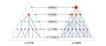
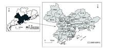
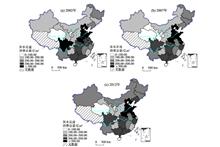
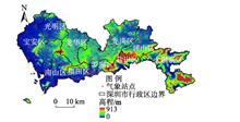
Scientific analysis of the spatial reconstruction of industrial development in the Beijing-Tianjin-Hebei urban agglomeration not only can contribute to expanding the scope and depth of research on industrial spatial change, but also can serve the national strategy of Beijing-Tianjin-Hebei coordinated development. From the perspective of global value chain (GVC), this study employed the method of measuring the industrial proportion change after calibration based on the statistical data from 2000 to 2014 and the national industrial enterprise database for 2001, 2006, and 2013 to investigate the spatial pattern of industrial development in the Beijing-Tianjin-Hebei urban agglomeration, and proposed the optimization strategies accordingly. The main conclusions are as follows: 1) The industrial spatial reconstruction is an important driving force for promoting the development and maturation of an urban agglomeration. Following the trend of globalization and embedding in global value chains are of great significance to advancing the upgrading of urban agglomerations, and domestic industrial spatial reconstruction is an important approach for improving the industrial cooperation network and accelerating the integration of urban agglomerations. In addition, the interaction of GVC restructuring, industrial suburbanization, and resource and environmental carrying capacity is the foudation of the double C-shaped spatial pattern. 2) With regard to the international industrial spatial reconstruction, Tianjin has become the core of the Beijing-Tianjin-Hebei urban agglomeration to undertake international industrial transfer, followed by Beijing, while the development of other cities is relatively lagging behind. On the whole, the Beijing-Tianjin-Hebei urban agglomeration is still in a lower position in the GVC, which is not conducive to the promotion of regional competitiveness. 3) In repect to the industrial spatial change within the urban agglomeration, industrial reconstruction is mailny concentrated in the inner C-shape region consisting of Beijing, Tianjin, Tangshan, and Cangzhou cities, while the intensity of spatial reconstruction in other regions is relatively weak. Different industries present diverse features of reconstruction: texile and garment industry is market-dominated within the GVC; chemical industry is influenced by both environmental regulations and dependence on water resources; steel industry is government-dominated; and pharmaceutical industry is regulated by the government under the influences of the GVC. 4) Based on the development of industrial spatial reconstruction, resource and environmental carrying capacity, and the double C-shaped spatial pattern, this article puts forward some suggestions on optimizing the industrial spatial patterns of the Beijing-Tianjin-Hebei urban agglomeration. As the economic core of the Beijing-Tianjin-Hebei urban agglomeration, the inner C-shaped region is recommended to accelerate industrial upgrading to become a world-class industrial highland. The northern part of the outer C-shaped area is proposed to strengthen ecological environment protection for the sustainable development of the urban agglomeration, while the southern part of the outer C-shaped area should promote industrial transformation to become a solid support for industrial upgrading in the Beijing-Tianjin-Hebei urban agglomeration. The two C-shaped regions should be interconnected to ensure the implementation of the coordinated development strategy of the Beijing-Tianjin-Hebei urban agglomeration.
The spatial restructuring of regional manufacturing industry involves the dispersion of different types of industries and change in industrial spatial structure. It is an important driving force for optimizing regional spatial organization and increasing regional competitiveness. Based on the aggregated data of manufacturing enterprises, this study used county as the basic unit of analysis to explore the spatial reconstruction features of manufacturing space in the Pearl River Delta urban agglomeration. The result shows that, the differences in spatial agglomeration and diffusion of different types of manufacturing industries have led to further change of the "core-periphery" structure of the urban agglomeration. Core cities have become more specialized in the development of technology-intensive industries, while peripheral cities have accommodated labor-intensive industries. Resource and environmental carrying capacity has significantly affected the changes in the spatial pattern of manufacturing industry. The shortage of land resources has prompted the manufacturing industry in general and particularly labor-intensive industries to shift to areas with more abundant land resources. Environmental stress has facilitated the proliferation of labor-intensive and capital-intensive industries in places with greater environmental carrying capacity. However, the impact of resource and environmental carrying capacity on technology-intensive industries is not obvious. In addition, the impact of traffic conditions, technological levels, policies, and other factors on different types of industries is significantly different, which jointly promote the industrial transformation of the Pearl River Delta urban agglomeration.
Water shortage and water pollution have seriously affected human survival and China's sustainable development. Analysis of water pollution in various regions and industries is the key for addressing China's environmental sustainability problem. This study used multiregional input-output tables for 2002, 2007, and 2012 on the basis of traditional greywater footprint research, calculated the process and final consumption grey water footprints of China's 30 provinces, municipalities, and autonomous regions (not including Tibet, Hong Kong, Macao and Tianwan) and 17 industries during 2002-2012, and the total grey water footprint transfer of the eight regions and 17 industries. The results show that: 1) The grey water footprints of large economic areas such as Shandong, Henan, and Hebei have been relatively high, and the grey water footprints of relatively small economies such as Qinghai, Ningxia, and Hainan have been relatively small. 2) Agriculture is the largest sector contributing to grey water footprint. The four industries in the commercial and transportation sectors have large grey water footprints, but their total is far less than the agricultural grey water footprint. The grey water footprints of five industrial sectors, such as other manufacturing industries, have been relatively small. 3) The net input area of grey water footprint is the Beijing-Tianjin region, northern coastal region, eastern coastal region, and southern coastal region. The sum of the two paths with the largest amount of grey water footprint transfer increases first and then decreases. The identified main grey water footprint outflow-inflow area is the central area-the eastern coastal area. 4) Agriculture and mining industry are the net export sectors of grey water footprints. Most light industries and tertiary industries are the net input sectors of grey water footprints. The identified major grey water footprint outflow-inflow sectors include agriculture-food manufacturing and tobacco processing, agriculture-textile services, and agriculture-chemical industries. The grey water footprints generated by various regions and industries and the grey water footprint paths identified for the regions and industries can provide a theoretical basis for reducing grey water production, and provide theoretical support for the rational use of regional and industrial water resources.
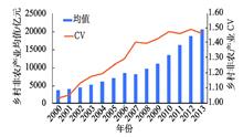
The development of rural non-farm sector (RNFS) is an important part of China's Rural Revitalization Strategy and the prerequisite for the prosperity of rural economy. Based on the data of Chinese township and village enterprises, this study examined the development of RNFS and its spatial pattern during 2000-2013 in China. On the basis of spatial and temporal analyses on RNFS, the spillover effects of RNFS on rural residents' income was studied by regression analysis from the spatial and temporal perspectives. The results show that: 1) The overall development of RNFS changed greatly. Temporally, the RNFS increased rapidly in China, but differences within the sector were enlarged. Spatially, there was an obviously east-central and west gap, and the agglomerations were mainly found in Shandong, Jiangsu, and Zhejiang Provinces. With regard to the structure of RNFS, industry took the dominant position, followed by wholesale and retail trade and construction. The eastern region relied more on industry than the central and western regions. 2) The rural non-farm sector had positive spillover effects on rural residents' income, which showed heterogeneity in space. The impact of RNFS on rural residents' income in the eastern region was stronger than that in the central and western regions. Over time, the impact of RNFS on residents' income is gradually weakening. Accordingly, some recommendations are put forward, including supporting the development of the central and western regions, improving the reform of the rural system, and developing various types of industries.
As one of the characteristic disasters of urbanization, heatwaves seriously affect the life and health of urban residents. Existing research on heatwaves mainly focuses on the spatial and temporal pattern based on static data, risk management, and vulnerability assessment, and studies on dynamic population exposure are relatively few. This study first integrated spatial and temporal distribution models of population and temperature hourly in Shenzhen to reveal the dynamic population exposure to heatwaves based on mobile phone location data. Then a set of geographically weighted regression models in different time were built based on seven types of points of interest (POIs) and population distribution to explore the influencing mechanisms of POIs on crowd behavior patterns during the heatwaves. The results show that: 1) Compared with the baseline (12:00 to 18:00 on 28 July 2018), the average radiation range of the heatwaves increases by 8.66 times on 29 July, and jumped to the peak of 18.93 times on 30 July from 26 July to 1 August 2018. The overall coverage shows that temperature in the west was higher than the east and temperature in the south was lower than the north. 2) Population distribution exhibited an obvious zonal distribution of aggregates in different time periods, and population exposure was closely related to the dynamic evolution of temperature and population. The population exposure was similar to that of heatwaves, showing 2.29 times proportional growth. The coverage included densely populated urban commercial, industrial, and residential centers such as Nanshan District, Futian District, and Luohu District. 3) The same type of POIs at different times and the different types of POIs at the same time showed obvious spatial-temporal differences as driving mechanisms and selection preferences in the interactive mobility behavior of reducing population exposure. Under the background of sustainable urbanization, this research can provide a scientific reference for the analysis of population exposure to similar urban hazards and disasters.
Land surface elements such as land use / land cover are in constant change and dynamic balance, driving the changes of global ecological processes and forming the regional differentiation of landscape, which cause many ecological risks under multi-source stresses. Based on a probability-loss risk model, a multiple hazards and potential ecological damage approach was used to construct a regional ecological risk evaluation system of Shaanxi Province. After identifying multiple hazard types from the perspective of geomorphologic regionalization, potential ecological damages were synthesized by taking landscape pattern and ecosystem services value losses as related factors. The spatial and temporal differentiation of individual risk factors and regional ecological risks in Shaanxi Province between 2000 and 2015 were analyzed. Meanwhile, the spatial and temporal changes of ecological risks were demonstrated from the perspective of geomorphologic regionalization and risk gravity model. Several conclusions were drawn from this analysis: 1) In 2000 and 2015, the multiple hazards index values of Shaanxi Province were 0.3837 and 0.4558, respectively, with an increase of 18.79%. Multiple hazards presented the spatial pattern of high in the north and south and low in the middle, with a W-shaped distribution along the north-south axis. Potential ecological damages were 0.5537 and 0.6270, up by 13.24%. Except for the southern part of the Loess Plateau and the eastern part of the Qinling Mountains, potential ecological damages were high. The regional ecological risks were 0.2429 and 0.2865, rising by 17.95%, and presented a spatial distribution pattern of "three high value areas sandwiched by two low value areas". 2) The ecological risks of the Qinling-Daba Mountains were low and the change rate of risks was small. The change rate of risks of the Loess Plateau and the sandification transitional zone was moderate, and the latter was facing a high risk. The Hanjiang Basin had the highest risks and the Hanjiang Basin and Guanzhong Plain took the first and second places in the change rate of risks, respectively. The risk gravity centers of the Loess Plateau and the sandification transitional zone both moved to the southwest, the risk gravity centers of the Guanzhong Plain and the Qinling Mountains moved significantly to the east, and the risk gravity centers of the Hanjiang Basin and the Daba Mountains jumped to the southeast.
Based on the MODIS evapotranspiration (ET) products (MOD 16) and the observation data of meteorological stations, coefficient of variation method and Sen+Mann-Kendall model were used to analyze the spatiotemporal feature, variation trends, and influencing factors of land surface ET and potential evapotranspiration (PET) in Shanxi Province from 2000 to 2014. The main conclusions are as follows: 1) The accuracy of the MOD16-ET (R2=0.9) of Shanxi can meet the requirements of such research, and can be used to examine the spatiotemporal distribution of surface ET. 2) The mean annual ET and PET were 816.77 mm and 1608.46 mm, respectively. The annual distribution showed a unimodal pattern, which increased first and then decreased; the difference between ET and PET was the largest in May and June when it was the driest in the study area. 3) The annual average ET of the study area was low in northwest Shanxi and high in southeast, while the annual average PET was high in southwest and low in northeast of the study area. The overall difference between the annual average ET and PET was relatively large, which reflects that the whole province was shortage of water, especially in Xinzhou and the west of Lvliang. 4) The interannual variations of ET and PET have been relatively small in the past 15 years. Evapotranspiration showed a decreasing trend, and PET showed an increasing trend, which suggest that the drought was aggravated in Shanxi in the past 15 years. 5) The correlation analysis between evapotranspiration and meteorological factors indicated that the spatiotemporal variation of evapotranspiration was closely related to many climatic factors—they were related to precipitation and relative humidity spatially, and were most closely related to temperature and precipitation temporally.
Residents' low-carbon behavior-cognition relationship has been widely concerned by scholars since cognition-behavior separation is a key factor that hinders the construction of low-carbon cities and the transformation of residents' lifestyle. This study constructed a spatial-behavioral/cognitive analysis framework and used large-scale field survey and remote sensing data of Zhengzhou City in 2018, as well as expert scoring method to estimate the low-carbon behavior level and low-carbon cognition level of 1485 families based on their daily travel and consumption of household energy. The color coding method was used to classify their behaviors into the green type, the forced type, the susceptible type, and the red type based on cognition-behavior gaps, and the multiple Logistic regression model was used to analyze the influencing factors of different low-carbon behaviors. The research findings show that: 1) There are large cognition-behavior gaps in low-carbon behaviors of residents in Zhengzhou City, and the proportions of the four low-carbon behaviors vary greatly. 2) Green low-carbon behaviors are mainly concentrated in areas with highly mixed land use and convenient infrastructure, and forced low-carbon behaviors, susceptible low-carbon behaviors, and red low-carbon behaviors are randomly distributed in space. 3) The influencing factors of the four types of low-carbon behaviors are very different. Residents living in areas with a high walking index score and a high level of low-carbon cognition tend to exhibit green low-carbon behaviors, and have a high level of low-carbon behavior and low-carbon cognition. In areas where housing conditions are relatively poor and residents have low levels of education, the residents tend to exhibit forced low-carbon behaviors, their low-carbon cognition level is low but low-carbon behavior level is high. Residents of high-end residential buildings tend to show susceptible low-carbon behaviors, they have a high level of low-carbon cognition but a low level of low-carbon behaviors. Young residents with high economic status tend to exhibit red low-carbon behaviors and have a low level of low-carbon behavior and low-carbon cognition.
Urban spatial cognition is a classic research topic of behavioral geography. In this study, we selected the main urban districts of Beijing and investigated the spatial cognition of graduate students of the University of Chinese Academy of Sciences using a combination of methods of cognitive map and questionnaire survey. We conducted the surveys in three stages of the same students and asked them to draw a sketch of the city of Beijing, then classified the sketch maps and counted the identified ground features. Based on statistical data, we analyzed the development process and the characteristics of differences of sketch maps of the surveyed students. The research shows that different from Kevin Lynch's five elements of space imagery, the basic elements of cognitive maps are three types: paths, domains, and landmarks, in which landmarks occupy the absolute dominant position. According to the combination of identified ground features in the sketch maps, the cognitive maps can be divided into three types: scattered structure, topological structure, and transitional structure between them, with scattered structure maps constituting the absolute majority. With the progression of time, imaginary space of the city gradually became complicated, and the spatial structure changed from single core to multiple cores; urban spatial cognition of the survey respondents showed the characteristics of personal preference, spatial non-equilibrium, individual difference, and incompleteness of the cognitive process. Beijing urban spatial cognition of the surveyed students is limited mainly because of the long distance from the target places, huge spatial scope of the city, short duration of stay of the students, and the respondents' own attributes that increase the difficulty for the students to imagine ground features of Beijing.
In modern society, cultural evolution follows the logic of capital, and the reconstruction of festivals is influenced by economic forces. Based on the research of the Shankang Tea Ancestor Festival of Bulang people in Mangjing Village, Jingmai Mountain, Yunnan Province, this article discusses the reconstruction process of the invented festival. In order to study the process and mechanism of the festival's reconstruction, four field investigations through participatory observation and non-participatory observation were carried out respectively in January 2015, April 2016, April 2017, and January 2018, and in-depth interviews were conducted with 38 local residents, government officials, and tourists. Empirical findings indicate that the festival reconstructs two main cultural systems of the Bulang people—the Tea Ancestor culture and the Tea Soul culture. The culture in festivals has become a cultural symbol in the market economy and has produced economic values. Economy becomes the external power of the construction of local culture and the native people's cultural identity becomes the internal driving force. The festival represents the local ethnic minority culture, promotes the development of tea economy, and improves the livings of local inhabitants. The Shankang Tea Ancestor Festival successfully integrates culture and economy, which in turn enriches the connotation of the festival. The study explored the cultural reconstruction of traditional festivals through an economic perspective and deeply revealed the evolution of meaning, which expands the theoretical research of traditional festivals.
China is in a critical period of economic transformation and social development, which brings great pressure and challenges to land use. Therefore, imbalanced land-use structure and conflicting land utilization become more common, which result in more attention to land-use conflicts and thus increasingly more related studies has appeared, but there is a lack of systematic review and compilation of existing research. This study examined the research related to land-use conflicts in China through literature analysis and comparative analysis, and identified the research trends. First, this article points out that land-use conflict refers to the phenomenon of spatial competition and conflicting interests between people and land caused by the way and structure of land use by stakeholders in the process of land use, which was defined by the comparison and identification among relevant concepts related to land-use conflicts in the existing literature. Second, the Chinese land-use conflict research results were summarized and elaborated from six aspects, including the theoretical basis of land-use conflicts, the stakeholders in land-use conflicts, the identification and intensity diagnosis of land-use conflicts, the forms and classification of land-use conflicts, the evolution of land-use conflicts and its driving mechanisms, and the reconciliation program of land-use conflicts. Finally, through reviewing and comparing Chinese and international research results, this article puts forward the future direction of China's land-use conflict research: 1) Complement and improvement of land-use conflicts theoretical system under the background of economic and social transformation. 2) Content expansion and paradigm innovation of land-use conflict research considering the global scale. 3) Spatial justice and efficiency of land-use conflict resolution in the context of rural revitalization strategy. 4) Quantitative and precision management of land-use conflicts with the support of participatory GIS. 5) Coordination and trade-off of land-use conflict resolution under the integration of national spatial planning systems. 6) Comprehensive analysis and results application of land-use conflicts from the perspective of multidisciplinary integration.
Achieving sustainable development in an increasingly interconnected globalized world requires cross-system thinking and more integrated regional policy. First, it requires disciplines devoted to sustainable development research to improve their insights into trans-regional resource and environmental issues. Accordingly, it is necessary to promote the adaptive innovation and transformation of the traditional research framework of geography. Telecoupling, as a theoretical framework focusing on socioeconomic and environmental interactions among coupled human and natural systems over distances, has great potential and advantages to facilitate the process of theoretical innovation. In order to narrow the gap between Chinese and international research in the field of telecoupling, we introduce the telecoupling framework and its application progress from theoretical construction, empirical evidence, key research areas, and research methods based on literature review, document analysis, and our own understanding of telecoupling, and further give some suggests. The review shows that there is a large amount of empirical evidence of telecoupling in the dimensions of teleconnection, globalization, and urbanization due to the continuous growth of long-distance human activities and their interaction with large-scale natural processes. Currently, the application of the telecoupling framework in academia mainly focuses on three aspects: ecosystem services, the socioeconomic and environmental impacts of telecoupling, and land change science. Due to the progress in operationalizing the theories, current telecoupling research has been well supported methodologically. We further argue that geographical research based on the telecoupling framework should make breakthroughs in the theoretical innovation of Human-Earth relationship network system, telecoupling mechanism, and telecoupling regulatory tool sets, so that scientific research can keep up with the latest trends and solve the emerging real world problems.
The traditional extensive urban land use will not meet the requirements of new urbanization. As a result, controlling urban sprawl and land use optimization have become one of the key tasks of land resources management. The purpose of this study is to provide new perspectives and identify research areas for urban growth boundary study through the review and analysis of existing theoretical models, methods, and effectiveness evaluation cases. The research methods we employed are literature review and induction and deduction. The results indicate that the theoretical basis of urban growth analysis came from monocentric city model. Most studies in China mainly focused on the impact of economic factors, industrial structure, and accessibility on urban growth while public policies and services, externality, and stakeholder power struggles are also thought to have effects on urban growth. Urban growth rigid boundary design is mainly based on suitability and carrying capacity assessments, and elastic boundary is usually modeled by using cellular automata. The effectiveness of urban growth boundary on controlling urban sprawl is different in different cities in developed countries. There are few case studies to evaluate the effectiveness of urban growth boundary in China. We should adopt diversified theories to study the mechanism of urban growth. The effects of multilevel drivers on urban growth should be considered in future research. Most importantly, stakeholder power struggles should be taken into consideration in future elastic boundary modeling. In order to make urban growth boundary policies sustainable and balance regional development, legal and management systems of urban growth boundary should be designed in the future.
From the spatial perspective, an urban agglomeration can be understood as the concentration of population and economic activities within a large urban region. In this urban region, the original rural areas were densely involved in industrialization and economic development. On the basis of a comprehensive review of classical theories, this article proposes to understand urban agglomeration from the unique characteristics of spatial patterns, namely, dispersed regional concentration. We believe that the dispersed regional concentration is the result of spatial choices of economic globalization and information technology revolution, and also the product of the unique policies and institutional background of China. As a unique reflection of global manufacturing platform and coordinated control center in space, this fundamental attribute makes urban agglomeration different from traditional regions and not ubiquitous in space. Its dispersive development characteristics represents the most serious resource and environmental constraints, which deserve special attention. The planning strategy based on these decentralized regional units may be easier to implement and achieve results than the current overall urban agglomeration strategy. At the same time, with the implementation of domestic consumption demand strategy and the Belt and Road initiative, the Chinese and international backgrounds of urban agglomeration development are undergoing important transformations. The spatial pattern of dispersed regional concentration does not necessarily apply to all regions of China. This fact is of great significance and must be carefully considered in future regional planning and management.