


Please enter the answer below before you can view the full text.
7-6=
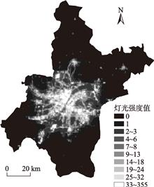
Based on the results of existing research, typical urban problems can be divided into three categories—traffic congestion, resources shortage, and environmental pollution. This study used cross-section data of 204 Chinese prefecture-level cities in 2013 to build a population spatial distribution index on the basis of nighttime light data for an empirical study. First, ordinary least squares (OLS) regression was applied to examine the impacts of city size, spatial imbalance, lagged infrastructure construction, industrial transformation, and institutional obstacles on urban problems. Second, a threshold effect model was constructed to further investigate possible nonlinear relationships between the influencing factors and urban problems. The empirical results prove that the various aspects of urban problems should be attributed to different influencing factors since these problems are complex. The main reasons leading to traffic congestion are big city size and centralized distribution of urban population, as well as the lack of transportation infrastructure. While resources shortage is not a universal problem in most big cities, in contrast, the improvement of industrial structure, increasing supply of public services, and concentration of administrative power are helpful for big cities to attract and bring in resources. The expansion of urban population and the agglomerated structure of population distribution both hinder environmental pollution control. Besides, the growth in the proportion of non-agricultural industries and expansion of urban road area both can damage urban ecosystems.
Research on the spatial-temporal change and intrinsic spatial correlation of metropolitan urban-rural integration zones can help cities to avoid inefficient sprawling development and achieve spatial structure coordination and smart growth. Taking the desakota region in Wuhan City as the case, we used the National Polar-Orbiting Partnership / Visible Infrared Imaging Radiometer Suite (NPP/VIIRS) nighttime light data to assess urban factor allocation and operational efficiency and effectiveness. This study then detected the spatial correlation intensity, spatial-temporal change of spatial connection potential, and the change of socioeconomic location index of the urban-rural integration areas during 2016-2018 using the gravity model. The results show that: 1) The desakota regions in Wuhan City have expanded by 28.10%, and sprawl most significantly to the northwest during 2016-2018. This process is characterized by the integration of small plaques and the enhancement of regional development continuity. 2) The spatial connection network structure among desakota regions in Wuhan tends to be polycentric, which originates from the changes of economic development levels, urbanization development scale, and traffic accessibility. Wuhan East Lake High-tech Development Zone, Sino-French Wuhan Ecological Demonstration City, Wuhan Airport Economic Zone and so on are the engine of regional development in a decentralized process. 3) The spatial correlation pattern of urban-rural integration areas in Wuhan has been transformed from the "large and small cores" structure consisted of Wuhong District and Jiangxia District to the "peripheral circle" structure composed of Jiangxia-Wuhong-Caihan-Jianghuang-Jiangqiaodong. The spatial connection intensities of desakoda regions have increased year by year, but Wuhong and Jiangxia Districts, as the core areas of Wuhan urban-rural integration area, failed to develop multi-directional spatial radiation and attractiveness, which led to insufficient positive effects to other areas. 4) The changes of socioeconomic location index of each urban-rural integration area show that the impact of existing Wuhan urban planning is more significant in the northern, western, and northeastern parts of urban-rural integration area.
Desert steppe is distributed in the semiarid and arid areas and is extremely sensitive to climate change. However, limited field observations and lack of community surveys have resulted in insufficient research on the vegetation phenology and productivity of the desert steppe. Based on the normalized difference vegetation index (NDVI) data from the MODIS dataset during 2000-2017, we used a relative threshold method to extract the phenological parameters in the desert steppe of Inner Mongolia, including the start of growing season (SOS), the end of growing season (EOS), and the length of growing season (LOS). We then estimated the spatiotemporal changes in net primary productivity (NPP) of the desert steppe vegetation by the Carnegie-Ames-Stanford Approach (CASA) model. Finally, we analyzed the relationship between desert steppe productivity, phenophases, and climate variables. Our results show that: 1) during the study period, SOS advanced significantly at a rate of 0.88 d/a (PP2·a) in the study area, showing regional differences with an obviously decreasing trend from east to west. Net primary productivity in spring, summer, and the growing season increased insignificantly, while NPP in autumn showed an insignificant decreasing trend. The increase of precipitation in the growing season is beneficial to the accumulation of ecosystem NPP. 3) Advance of SOS was conducive to the accumulation of spring NPP, and the delay of EOS promoted the accumulation of autumn NPP. There was a significant correlation between the LOS and NPP during the growing season (P<0.05). This study revealed the impacts of climate change on vegetation phenology and productivity of the desert steppe in Inner Mongolia, which is significant for ecosystem management and ecological construction of the region.
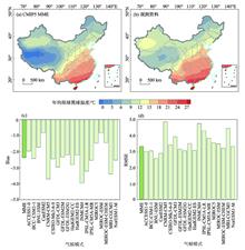
Humidity is a significant factor contributing to heat stress but it is not fully considered in studies quantifying heat stress or in heat risk assessment. It is directly related to human body heat exchange and the co-occurrence of consecutive hot and humid days during a heatwave can strongly affect human health. In this study, wet-bulb globe temperature (WBGT) considering both temperature and humidity effects was utilized as a heat index to define heatwaves. Using daily mean air temperature and relative humidity data from 824 meteorological stations for the reference period (1986-2005) and the corresponding CMIP5 multi-model simulations, spatial distribution characteristics and change of heatwaves that would occur in China's mainland were analyzed for the future period (2076-2095) under different greenhouse gas emission scenarios (RCP2.6, RCP4.5, and RCP8.5). Our analysis suggests that the average number of heatwave days in a year would be 3.4 and 6.6 times of that for the reference period under the most aggressive mitigation scenario (RCP2.6) and high emission scenario (RCP8.5), respectively. Average heatwave amplitude (as defined by the peak daily WBGT in the hottest heatwave in a year) would increase 4.9 ℃ under RCP8.5 as opposed to about 1.6 ℃ under RCP2.6. In the future period, the highest annual heatwave amplitude of eastern and southern China would reach 40 ℃ under the RCP8.5 scenario, which is higher than the optimum body core temperature (near 37 ℃). Although the Tibet Plateau has low heat amplitude, increase in the annual total heatwave days is rather significant in the future period. Heatwaves in the future would be most serious over southern China, the middle and lower reaches of the Yangtze River and parts of southwestern China considering both temperature and humidity effects on human thermal comfort. It suggests that without taking surface air humidity into consideration, there could likely be an underestimation of intensity and influences of heatwaves over areas with high humidity (such as southern and eastern China).
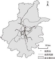
Urban geographic space, climate, and transportation system are interrelated, and recently available traffic and spatial big data bring new opportunities for understanding the relationship among them. Urban rail transit is an important transport mode for residents to travel green and relieve traffic congestion in big cities in China. In-depth study of factors that affect the changes in the spatial and temporal distributions of metro passenger flows is conducive to the formulation of reasonable land use and traffic demand management policies, and can also provide a theoretical basis for real-time response to the changes in travel demand under specific weather conditions and optimization of transit service operation. To study the impact of weather conditions on metro usage in densely populated areas, in this research the influence of local weather factors (including temperature, humidity, rainfall and so on) on hourly metro passenger flows was investigated based on metro smart card data and weather data from Nanjing City, China. A time series model—seasonal autoregressive integrated moving average with explanatory variables (SARIMAX)—was developed to investigate the impact of weather conditions on metro passenger flows. It is found that some weather factors such as rainfall have significant influence on metro passenger flows. Except for some special sites (large residential areas and large transportation hubs), the influence of weather factors on metro passenger flows reduces gradually from the city center to suburban areas. The effects of weather conditions on regular metro passengers and irregular metro passengers were explicitly compared in this study. Irregular metro passengers are found more vulnerable to adverse weather conditions than regular metro passengers.
The identification of rural territorial functions of major agricultural areas can provide an important support for rural revitalization and food security. The Jianghan Plain is one of the main agricultural areas in China and is undergoing a rapid rural transformation and reconstruction. From the perspective of ecological, production, and living spaces, this study constructed an indicator system for the assessment of production, living, and ecological functions of rural areas. Using the entropy weight method to determine the weights of indicators, we examined the pattern of change of rural territorial functions in the rural areas of the Jianghan Plain from 2000 to 2015. The influencing mechanism of change was analyzed by applying spatial econometric models. The results show that: 1) The total index value of rural territorial functions of the rural area in the Jianghan Plain increased notably. Values of the three sub-index of production, living, and ecological functions increased by 78.26%, 34.25%, and 9.69%. Growths in the production function and living function were the two main ways of rural function improvement in the Jianghan Plain. 2) The rural function index values of the Jianghan Plain showed prominent spatial differentiation, with an overall east-west divide. Specifically, counties dominated by ecological function mostly aggregated on the northern fringe of the Jianghan Plain, while those dominated by living function aggregated on the central and southern part of the Jianghan Plain, and those dominated by production function showed a random spatial distribution. Ecological function and living function played a major part in the change of rural functions in the Jianghan Plain. 3) We argue that the factors that affect rural development can be divided into two types, namely exogenous driving forces and endogenous responses. The results of the spatial econometric models indicate that both types have an impact on the change in rural territorial functions in the Jianghan Plain. More specifically, the exogenous factors showed a positive influence on the change of rural function in the Jianghan Plain, while the endogenous factors showed a negative effect. The greatest impacts of both the exogenous and the endogenous factors were on production function, followed by living function and total function. The marketization response had spatial spillover effects on the change of rural territorial functions of the Jianghan Plain. Our findings indicate that developing multifunctional agriculture in the Jianghan Plain is a rational choice. In practice, exploring change and influencing mechanism of rural territorial functions for major agricultural areas, on the one hand will be helpful for identifying different patterns of rural development and providing guidance for the implementation of rural revitalization. On the other hand, research on functional types of rural areas could have a broad impact on rural development and urban and rural coordination. Due to the differences in major territorial functions and external conditions, we suggest that the applicability of the evaluation index system and influencing mechanism should vary along with the territorial types.
Deep poverty-stricken counties are the key areas for targeted poverty alleviation, and objective analysis of the poverty pattern and influencing factors in these areas can provide a scientific basis for developing the tactics of poverty relief. This study applied spatial analysis and mathematical statistics methods to explore the poverty pattern and influencing factors of Hailun City, Heilongjiang Province, by taking poverty villages and poverty population as the focus. The results show that: 1) As a deep poverty-stricken county, Hailun's poverty villages and poverty population are unbalanced, and their spatial patterns are related and different. 2) The poverty villages of Hailun City centralize in the terrain transition zone of 150-250 m, presenting a multi-core zonal distribution pattern. 3) The distribution pattern of poverty population in Hailun results from the joint effects of natural and human factors. Physical geographic conditions, agricultural production, rural infrastructure, and social welfare are key factors. In order to strengthen targeted poverty alleviation and rural revitalization, it is important to strengthen agricultural infrastructure and improve the ability of resisting natural hazards and disasters; accelerate planting structure adjustment and layout optimization and improve rural industrial development level; improve social insurance level and reduce the risks of causing and returning to poverty; optimize settlement system and promote space reorganization, restructuring, and functional readjustment of various key rural factors.
In recent years, urban networks have become a focus of research in geography, urban studies, and other related disciplines. While previous research has examined the urban networks in China from different perspectives, the networks generated by cultural industries have remained a largely unexplored area. This article aims to fill this gap by presenting a comprehensive analysis of the spatial structures of the cultural industry-generated urban networks in China's mainland and compares the disparities between these networks and the urban networks created by other types of economic activities. Data of the headquarter-affiliation connections of 230 NEEQ (National Equities Exchange and Quotations)-listed cultural firms in 2017 were collected and analyzed using social network analysis method. In addition, the article also explores the economic and social factors that shape the formation of the spatial patterns of China's cultural industry urban networks drawing on the method of multiple linear regression (MLR). The outcomes reveal that: First, shaped by both market mechanisms and the interventions of local governments, the distribution of the NEEQ-listed cultural firms demonstrates a geographically dispersive, but quantitatively concentrated pattern in China. The spatial structure of the cultural industry urban networks is highly uneven, with most inter-city connections concentrated in the eastern part of the country. The cultural industry urban networks do not exhibit the typical diamond-shaped structure that has been observed in many other urban networks in China. Second, the core nodes of the cultural industry urban networks are mainly economically advanced metropolises in the eastern and central areas, as well as a few minor cities that possess some special local assets, including large film and television studios, unque natural or humanistic environment, and preferential tax policies. Most cities are receivers instead of exporters of cultural industry functions. Third, the expansion of the cultural industry urban networks is mainly between the core nodes of different hierarchies instead of between geographically proximate cities. The contribution of local (intra-urban) networks to the formation of intra-firm relationships of cultural industries is weaker than that of trans-local networks, which indicates that, compared with the advantages of geographical proximity, the complementarity of market or resources is the primary factor considered by cultural firms during their expansion. Fourth, the urban networks of different subsets of cultural industries have rather diverse spatial structures, which reflect the varied market demands and development conditions of different cultural industry activities. Fifth, according to the outcome of MLR analysis, the function of local governments and urban industrial structure are two important factors that shape the location strategy of cultural firms and the pattern of cultural industry urban networks in China, whereas the impacts of other economic and social factors are not significant. The article enriches our understanding of the spatial organization of cultural industries and the diversity of modern urban networks. It also sheds light on cultural industry development policies in the Chinese context.
Food production is an important aspect affecting greenhouse gas emissions. As carbon emission intensity coefficient values of different food types vary greatly, the improvement in economic development levels and living standards and the resulting rapid change of resident food consumption in China have important impacts on the ecological environment and carbon emissions in the country. This study examined the trend of change of urban and rural resident food consumptions in China from 1997 to 2016, and analyzed its spatial-temporal agglomeration characteristics and driving factors with the Lorentz curve and Gini coefficient. The main conclusions are as follows: The total quantity and per capita share of Chinese resident diet carbon emissions were increasing gradually, but they still belong to the low-carbon consumption category globally. Structurally the various kinds of resident diet carbon emissions in China showed different trends of change, and animal food carbon emission increment rate was faster than plant food reduction rate. Residents' diet carbon emissions showed a significant urban-rural division in quantity, structure, and trend, but the gap is narrowing in recent years. Per capita emissions showed significant differences among the ethnic groups and regions, and the high value regions of food consumption carbon emission density were mainly distributed in the municipalities and economically developed coastal areas. Structural optimization was the main direct driving factor of the national food consumption carbon emission change in China, while population was the main factor of regional differentiation.
In recent years, with the rapid development of socio-economy and acceleration of urbanization, China has entered the stage of a health transition, which means a shift to low fiber, high sugar and cholesterol diet, as well as a sedentary lifestyle. During the health transition, Chinese residents are facing severe obesity and the problems caused by metabolic system-related diseases. So it is significantly important to find the factors which influencing the physical health of Chinese residents during the special period. This study is based on longitudinal tracking survey data of 29586 adult residents from 635 communities in 25 provinces across the country from 2010 to 2016, using non-linear development models and multi-level logistic regression models to explain the trends of overweight or obesity in Chinese residents, and explore the mechanism under the interaction of individuals and the environment. The results show that the risk of overweight and obesity in Chinese adults measured by body mass index increased year by year, in which women, age, spouses, and average daily exercise time negatively affect the growth rate of Chinese body mass index. Moreover, the differences in overweight and obesity among Chinese adults are multilayered. Socioeconomic attributes, dietary habits, and behavioral patterns at the individual level, the built environment and natural environment at the community level, and the level of urbanization at the provincial level can all affect the occurrence of overweight and obesity in China. Finally, the influence factors of overweight and obesity between different levels have an interactive relationship, and the environment can indirectly affect the residents' overweight and obesity results by affecting the individual's psychological state and behavior choices. The purpose of this research is to help residents achieve better health and to provide theoretical basis for government agencies to formulate policies to promote population health.
Western cities in China experience large-scale, rapid, and vast-invested transport infrastructure construction, which makes it particularly important to evaluate the social economic impacts of these projects. Based on trip survey data in Urumqi in 2014 and multivariate linear regression and multinomial Logit regression model with cross variables, this study explored the impact of bus rapid transit system (BRT) on job satisfaction. The results show that measured by commuting time, employment accessibility levels are lower for the low-income group, the male, property owners, and private car drivers, while accessibility levels are higher for commuters with shorter distance to BRT stops. In terms of job satisfaction, the low-income people are likely to report lower level of job satisfaction, while those with shorter distance to BRT stop and private car drivers are likely to report higher job satisfaction. It also shows that shorter time commuters do not necessarily report higher level of job satisfaction. These results indicate that overall public transport infrastructure has a positive promoting effect on both employment accessibility and job satisfaction, but the differential impacts of individual attributes also cannot be neglected. The policy implication of this study lies in helping with making the public policy to improve employment accessibility and job satisfaction of the low-income group of urban residents, which will further promote local employment stability and regional economy growth.
With the changing climate and rapid urban development, megacities and urban agglomerations suffer from frequent extreme weathers caused by high temperature and heavy rain and haze, and ecological and environmental problems become increasingly more prominent. Urban planning in response to climate change is an important means to reduce the negative influence of urban climate, environment, and extreme events, through optimization of land use, spatial structure, road traffic, and greening of urban spaces. This article summarizes the impact mechanisms of urban planning implementation on the climate and the environment and examines the evaluation methods of urban planning implementation effects. In consideration of making urban planning in respond to climate change, we put forward a viewpoint to solving optimization problems with multiple controls, objectives, and constraints based on extreme events index, economic feasibility, and regional applicability. We maintain that it is urgent to conduct impact and adaptation research on urban climate change based on the interactions of climate, environment, and social economic systems, including improving the evaluation methods and constructing the multi-scale integrated assessment system of urban planning effects, in order to realize the green, smart, and resilient urban development strategy with the optimal climate environment and the minimum social and economic costs.
In many Western countries, geographic studies on long-term care for the elderly originated from geriatrics and nursing science, and then from the sub-fields of medical geography, health geography, and disability geography, and care geography—a new interdisciplinary field has emerged. Medicine, health, disability, and health care are core issues in the studies on the changing geography of elderly care, which has focused increasingly more on long-term care in recent years. Based on an intensive review of Western literature, this article extracts five themes from existing geographic studies on long-term care for the elderly, that is, the geographical distribution of long-term care needs of the elderly, the accessibility of care facilities and change, the use of long-term care and barriers for the utilization, the care experience of people in relation to space and place, and discussion on long-term care policies. In recent years, Chinese geographers have been paying more attention to the aging problem. However, the research perspective has been still relatively narrow and few academic papers have been published in the China National Knowledge Infrastructure (CNKI) library so far. Geographic research on long-term care for the disabled elderly is a brand new field. Given the substantial amount of disabled elderly population in increasing proportions, long-term care provision has become the key issue and major focus of the elderly support system in China. Thus it is of high scientific value and urgent practical needs to carry out geographic research on long-term care for the elderly. It may not be unreasonable to suggest that researchers provide geographic perspectives to their research with regard to the socioeconomic backgrounds, policy demand, and research foci in China. Through a comparative study of the Chinese and Western contexts, the emphases of research in the future are proposed with the aim to develop deeper insights for elderly long-term care policies in China, including geographic database, theories, and research system construction.
Human geographers gain insights into social phenomena through home. Domestic violence has become a research object along with the cultural turn in Western human geography and the rise of feminist studies. Under the dual influence of feminist social criticism and the spatial perspective of geography, feminist geographers focus on women's spatial and emotional experiences, unfolding the violence against women in the home. Starting with the introduction of the concept of "domestic violence" and the public/private dichotomy, this article points out the spatial concealment of domestic violence and introduces the research path of domestic violence issue in feminist geography, that is, to discuss domestic violence beyond the public/private dichotomy of space by examining the meaning construction of home as private space and the broader geographical environment for tolerating the existence of domestic violence. Based on the review of related international research, this article summarizes feminist geographic research of domestic violence on three scales: home, community/neighborhood, and global and national. Following the scale logic, this article concludes the findings of academic significance and provides insights on the trend of future geographic research of domestic violence issue. The implicit assumptions of home within analyses of domestic violence require further examination. The analysis of home in material, functional, and symbolic dimensions reveals the spatial control and oppression on women. The two perspectives of material determinism logic and sociocultural logic provide insights into the characteristics of community environment in which domestic violence persists and their inherent policy and institutional exclusion to women. The research on the connections between domestic violence and terrorism and warfare reflects that violence on the micro scale intertwined with larger (geopolitical) processes, which can remap the debate about safety in political geography.
The complex flows of religions at the global scale are embedded in lived experiences of migrants, which have produced new types of urban spaces. In the context of globalization, religious diversity is not only a reflection on cultural globalization, but also a representation of migrants' intersectional identities. This article reviews how geographers of religion explore and understand the relations between religions and urban spaces from a Western perspective in the past three decades. To elaborate, this article focuses on how religion become a force that shapes the structures and fabrics of urban spaces and the society, drawing on a critical review of progress in Anglophone geographies of religions in Western societies. It identifies four key research streams in the Western studies on religion and urban spaces: 1) The emergent religious spaces are diverse and distinctive in urban areas, which are transient and liminal; 2) The multi-functional religious facilities play increasingly crucial roles in cities as they actively engage in urban public affairs; 3) Integration and segregation are apparently represented in religious believers' residential areas; and 4) Religious believers' embodied behaviors manifest their intersectional identities in urban spaces. Moreover, this body of works has considered religion as a new source producing contested urban spaces. That is, religion can be understood as a mediation of complicated social relations in the multicultural Western society. In the recent decades, the terms "visibility" and "invisibility" are frequently addressed to examine the presence and manifestation of immigrants' religious identities in the public sphere of the West. Scholars have indicated that the local adaptation of transnational religious culture has transformed the invisible or intangible religious landscapes and embodied practices into visible urban spaces in the West. Such visibility of transnational religious landscapes have not only altered the social orders, but also challenged the social relations in local communities. Despite that these debates are overwhelmingly discussed in the Anglophone literature, they are ignored by Chinese scholars. Thus, this research can be read as a contribution to current Chinese human geography that sheds light on Chinese geographies of difference and diversity, and rethinks the ways in which multiple cultures are governed in the globalizing urban China, based on a critical review.
With the rapid development of urbanization, environmental issues have become increasingly prominent, and research on human settlements has become a hot topic in academia. Based on the literature about human settlements in China National Knowledge Infrastructure (CNKI) and Web of Science databases, this study analyzed the important research areas of human settlements in China and internationally with CiteSpace software, and discussed the progress of data acquisition methods, research methods and technologies, and research perspectives. The results show that: 1) The data acquisition method has changed from traditional sampling survey and official statistics acquisition to satellite remote sensing, equipment perception, thus realizing the transformation of traditional data to network big data acquisition. 2) The research methods are becoming increasingly more advanced, focusing on the combination of questionnaire survey, new geometrics models, and GIS, and introducing advanced technologies such as Internet of Things big data and artificial intelligence to make research methods more diverse and research results more accurate. 3) Social perception, rural revitalization, and mimicry of human habitat have become the research directions in recent years. In the future, the study of human settlements should make comprehensive use of the data acquired by traditional methods and modern technological means, learn and mine big data at much greater depth, and strengthen the study of rural revitalization and virtual human settlements.