


 View fulltext
Journal of Atmospheric and Environmental Optics
Co-Editors-in-Chief
Wenqing Liu
GU Wenjun, YUAN Ye, CHEN Lanxiadi, CAO Yanan, PENG Chao, and TANG Mingjin
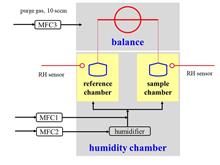
As one of the most important physical and chemical properties of atmospheric particulate matter, hygroscopicity can directly affect the particle size, morphology, chemical composition, chemical reactivity, and optical properties of aerosol particles under ambient conditions, thereby ultimately having an impact on the environmental and climatic effects of aerosol particles. Most existing widely used hygroscopicity measurement techniques have low sensitivity and assume that the particles are spherical, making it difficult to accurately determine the hygroscopicity of non-spherical or low-hygroscopic particulate matter. Comparatively, vapor sorption analyzer studies the hygroscopicity of particles by measuring the mass change of particle samples as a function of relative humidity. This new method not only has no requirements for particle morphology, but also has excellent measurement sensitivity. In this paper, the working principle and technical characteristics of this new method for aerosol hygroscopic measurement are introduced firstly, and then the application of this new method in atmospheric science, earth and planetary science, medical aerosol particles, and other fields is described in detail. Finally, based on the brief summary of the advantages and limitations of the vapor sorption analyzer in the study of atmospheric particle hygroscopicity, some future research directions are discussed and prospected.
Jan. 28, 2024Vol. 19 Issue 1 1 (2024)
GU Taofeng, YUE Haiyan, WANG Sihua, WU Guangsheng, FENG Houwen, TANG Ziheng, ZHUANG Peng, KANG Baorong, and XIE Chenbo
Accurate observation of atmospheric wind field is of great significance in meteorology, military, aerospace and other fields. Coherent wind lidar can detect the atmospheric vector wind field effectively and in real time. A coherent wind lidar based on the Doppler principle is developed in this work, and its performance is demonstrated in field observations. The system can detect the horizontal wind field and vertical airflow with a vertical altitude from 45 m to 3000 m and its maximum detectable wind speed is 60 m/s. The observation data of the lidar at Huangpu District Meteorological Bureau in Guangzhou, China, from 08:00 on October 16, 2021 to 00:00 on October 20, 2021, is analyzed and compared with that of the microwave wind profile lidar at the same location during the same period, and it shows that the two observation data are in good agreement. Finally, the typical observation data from 10:00 on October 18 to 00:00 on October 20, 2021, are selected for key analysis to further verify the accuracy of the data measured by the coherent wind lidar. The application of the developed lidar in wind field detection will provide real-time data support for the improvement of meteorological parameter monitoring and forecast accuracy, as well as the early warning of extreme disastrous weather.
Jan. 28, 2024Vol. 19 Issue 1 22 (2024)
CHEN Zhihao, ZHAO Nanjing, YIN Gaofang, MA Mingjun, DONG Ming, HUA Hui, and DING Zhichao
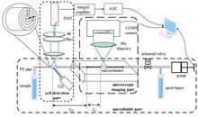
The rapid and automatic acquisition of microscopic images of algae cells has important application value. To address the issues of sample injection efficiency and cell imaging quality in microfluidic-microscopic imaging technology, a method for detecting the average flow rate of samples based on the duration of algal cells passing through the fluorescence detection window is studied, and a segmented control method of microfluidic auto-injection based on volume flow regulation is proposed. The results show that the average flow rate detection error of the sample is less than 5% when the sampling speed is within the range of 10-30 μL/min, and the segmented control realizes the automatic acquisition of high-quality microscopic images for algae cells. The quality of the microscopic images is basically consistent with that of microscopy, while the sample injection speed is increased by more than 68%. The research results provide an effective and practical method for efficient and automatic acquisition of microscopic images of algae cells.
Jan. 28, 2024Vol. 19 Issue 1 38 (2024)
WU Yarui, LIU Honglei, and LOU Chunhui
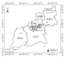
During the COVID-19 pandemic in 2019 and 2021, strong control measures were taken in Xi'an, China, therefore, the impact of different degrees of emission reduction measures on air quality was studied comparatively. In this work, the characteristics of air quality changes during the pandemic period (December 2019-February 2020 and December 2021-February 2022) and the normal production period (December 2020-February 2021) in Xi'an were compared and analyzed by methods of characteristic radar map, spatial interpolation and HYPLIST trajectory model, and the potential causes of air quality change under anthropogenic emission reduction scenarios were discussed. The results show that: (1) The overall spatial distribution of air quality index (AQI) in Xi'an exhibits a characteristic of "inferior in northwest and superior in southeast". In 2020, the air quality of Xi'an city was significantly improved during the strict pandemic control period, with 53% days with the air quality being excellent and good. While in 2022, the air quality was not significantly affected by the strict epidemic control measures. (2) During the strict control period of the epidemic in 2020, except for O3 the concentrations of other pollutants, decreased significantly, with PM2.5 (42.90%) > NO2 (42.13%) > CO (35.37%) > PM10 (32.58%) > SO2 (17.40%). While in 2022, only SO2 and NO2 concentrations decreased, with a decrease of NO2 (31.86%) > SO2 (18.31%).The type of pollution during the pandemic was mainly secondary pollution. (3) During the pandemic period, polluted weather was mainly caused by anthropogenic source emissions and regional pollutant transport on the basis of high humidity, calm wind weather conditions and basin topography. Therefore, promoting the coordinated reduction of pollutant emission, as well as joint prevention and control in Guanzhong area, is the key measure to improve air quality.
Jan. 28, 2024Vol. 19 Issue 1 47 (2024)
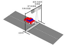
DUAN Peijie, LI Zerui, LI Kun, XU Zhenyi, LYU Zhao, and KANG Yu
Since the pollution gases produced by on-road high-emitters are significantly harmful to the environment, it is of great significance to identify on-road high-emitters accurately. However, there is still a relatively large promotion space for identifying high-emitters in model selection, evaluation metrics, recognition performance, and other aspects, for both traditional cutpoint-based methods and emerging artificial intelligence-based methods. Therefore, to address the above issues, a method for on-road high-emitters identification is proposed based on mixed kernel extreme learning machine. The method uses mobile source telemetry data obtained from on-road remote sensing detection equipment, and integrates different kernel functions on the basis of kernel extreme learning machine, which can improve the robustness of the model and the recognition performance of on-road high-emitters. The experimental results on remote sensing data collected from the traffic network in Shushan District of Hefei City, China, show that, compared with the other methods, the proposed method has a higher F1-Score, lower missing alarm rate and false alarm rate, which confirms the effectiveness of the method in high-emitter identification. It is indicated that the proposed method can help to identify high-emitters in the traffic road network efficiently and provide basic support for further improving urban air quality.
Jan. 28, 2024Vol. 19 Issue 1 62 (2024)
MIAO Junfeng, TANG Bin, CHEN Qing, LONG Zourong, YE Binqiang, ZHOU Yan, ZHANG Jinfu, ZHAO Mingfu, and ZHOU Mi
The classification of industrial wastewater is a prerequisite and foundation for water pollution prevention and water resources management. However, compared to domestic sewage, research on industrial wastewater classification is relatively lagging behind. Chemical Oxygen Demand (COD) of water is a core indicator for measuring water quality. To address the problem of low prediction accuracy in existing industrial wastewater COD classification algorithms, a convolutional neural network (CNN) hybrid model based on gated recurrent units (GRU) is proposed. According to the hybrid model, the COD data of industrial wastewater measured by UV-Vis spectroscopy is subjected to Gaussian filtering and denoising at the first, then the denoised spectral data is input into the CNN model for feature extraction, and finally, COD classification of industrial wastewater is achieved using GRU neural network. The experimental results show that the CNN-GRU classification model converges after 200 times of training, with a classification accuracy of 99.5%. Compared with the long short-term memory method, the GRU method, and the CNN-LSTM method, the classification accuracy of CNN-GRU method has a significant advantage.
Jan. 28, 2024Vol. 19 Issue 1 73 (2024)

GU Xiaoping, LI Guangyi, CHEN Yuanhang, and LIAO Yao
Guizhou Province of China belongs to a typical karst mountainous area, and due to the influence of terrain and climate, there are obvious spatial and temporal differences in the concentration of polluting gases in different regions of the province. Therefore, based on L3 V003 column amount data from the Ozone Monitoring Instrument (OMI) and the ground environmental monitoring station data, the spatio-temporal differences in the concentration changes and the spatiotemporal evolution characteristics of the three main pollutants in Guizhou Province were analyzed and evaluated at the regional scale, using interactive data language (IDL) plus the remote sensing image processing platform ENVI, geographic information system software ArcGIS, etc. The results show that: (1) The NO2, SO2 and O3 column amount in Guizhou Province in 2019 show a downward trend compared to 2005. The seasonal characteristics of NO2 and SO2 concentration monitored by the two methods both show high in autumn and winter, and low in spring and summer. While due to the influence of solar radiation and weather processes, O3 concentration monitored by the two methods show the same seasonal characteristics of "high in spring and summer, low in autumn and winter". (2) Both the maximum NO2 column amount and the minimum SO2 column amount monitored by remote sensing have a lag in time campared to ground monitoring results, but the lag time is short and there is no cross seasonal difference. Overall, their spatial differences are greater than temporal differences, and the spatial differences of SO2 concentration in summer are greater than in winter. (3) The stratosphere contains a lot of ozone in nature, and there are more thunderstorms in Guizhou Province in summer, so when the weather process occurs, oxygen in the high atmosphere is easily decomposed to generate O3 in large quantities. Due to the active vertical atmospheric transport, the stability of stratospheric O3 is reduced, which has a greater impact on the near-surface O3 concentration.Therefore, the O3 column amount monitored by remote sensing and the ground monitoring results are significantly different in time and space.
Jan. 28, 2024Vol. 19 Issue 1 85 (2024)
GUO Jianjun, LI Faquan, ZHANG Zihao, ZHANG Huiliang, LI Juan, WU Kuijun, and HE Weiwei
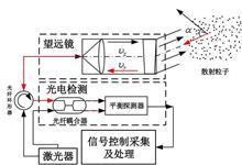
SO2 UV camera has been successfully applied in volcanic activity monitoring and its dynamics research due to its remarkable advantages in temporal resolution, spatial resolution, detection sensitivity, and detection accuracy. To address the issues that SO2 emission rate retrieved from UV camera images is easily affected by plume turbulence and the imges obtined are often with low contras, an optical flow algorithm incorporating neural network is proposed in this work. Firstly, based on the characteristics of atmospheric ultraviolet radiation transmission, the working mechanism of the SO2 UV camera and the inversion method of SO2 concentration image are described. Secondly, the neural network is integrated into the optical flow algorithm to achieve accurate inversion of SO2 emission rate in volcanic plume images; Finally, compared with the traditional optical flow methods, the superiority and accuracy of the proposed neural network optical flow algorithm is confirmed. The experimental results show that the neural network optical flow method can reduce the error of edge inversion from 94% to 5% even under the dual influence of low contrast of images and plume turbulence effect, significantly improving the accuracy of SO2 emission rate inversion.
Jan. 28, 2024Vol. 19 Issue 1 98 (2024)
WANG Hao, SUN Xiaobing, LIU Xiao, SONG Qiang, and HONG Jin
The scattering of sunlight during its transmission process in the earth's atmosphere has inherent polarization characteristics. Therefore, utilizing the polarization state distribution of atmospheric scattering and its corresponding relationship with the geometry of solar irradiation and surface observation, provides the possibility for navigation in the earth's atmosphere. However, the change of atmospheric composition caused by meteorological changes can directly affect the distribution of light scattering, further affecting the positioning accuracy based on the distribution of polarization state. So, in practical application, the accuracy of polarization navigation guidance is greatly affected by atmospheric conditions. In order to study the inherent mechanism of sky polarization state change under different meteorological conditions, an automatic measuring instrument for sky VIS-NIR spectrum polarization state was developed. The instrument can measure the spectral polarization state of the sky in a fixed time period and in a fixed sky area according to the settings, and adopts a non-imaging measurement method of time division polarization and simultaneous spectrum division. The instrument is mainly composed of a polarization analysis module, a positioning drive motor, a miniature spectrometer, a GPS positioning module, an embedded acquisition control module, a 2-D load turntable and other parts. Its spectral range is 390-960 nm, with spectral resolution of 1.5 nm, observation field of 3°, spectral linear polarization measurement accuracy better than 98.85%, polarization angle measurement accuracy better than 0.1°, and single-point observation time less than 9 seconds. Throught laboratory calibration and field tests, it has been verified that the instrument can stably observe the sky spectral polarization state under various meteorological conditions, and its measurement data can be used to study the influence mechanism of sky polarization state.
Jan. 28, 2024Vol. 19 Issue 1 111 (2024)
© Copyright 2018-2021 | Chinese Laser Press.
All Rights Reserved 沪ICP备15018463号-20