


Please enter the answer below before you can view the full text.
9-9=
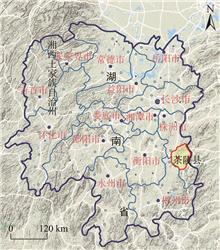
The spatio-temporal distribution characteristics and change of mountain populations are of great significance for coordinating human-land relationship and implementing the rural revitalization strategy in the process of urbanization. Based on the data of three agricultural censuses in Luoyang City, this study selected 318 administrative villages in Song County as the research objects, and used a GIS spatial analysis tool and geographically weighted regression to analyze the spatial pattern of population distribution and its influencing factors. The results show that: 1) The population of Song County is extremely uneven in spatial distribution. The high density areas are clustered near the main traffic lines and in areas with relatively flat terrain, and over time, they changed from point to spread and strip distribution. 2) On the whole, the population growth is bounded by the high-speed Luoluan Highway, and shows a pattern of rapid growth to the northwest and slow growth to the southeast. The high-speed growth areas are mainly concentrated in the county seat and a few townships around the northwestern part of the Luoluan Highway. 3) The population growth centers are also located in the towns around the county seat and the Luhun Reservoir, and the towns in the southern mountainous areas are expected to form new population agglomeration areas. 4) The population distribution pattern of the county is the result of the interaction of natural conditions, geographical location, and public services. Among them, the accessibility time of county seat has the greatest impact on population distribution, followed by topography. The impact of arable land area and accessibility time of middle school are relatively small, but the impact of different factors has spatial and temporal heterogeneity. The above conclusions imply that mountainous counties can take into account the differences in natural conditions and resource endowments, and make use of urbanization layout, infrastructure construction, and public services adjustments to promote the optimization of population distribution.
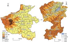
County space is the basic unit of spatial planning that shows the greatest urban and rural integration in China. The conflicts or overlaps between spatial development and spatial constraint are particularly prominent in county level territorial spatial planning. Chaling County is a typical hilly area in Hunan Province. Based on land use suitability evaluation and resilience spatial measurement, this study developed a land use resilience evaluation system in typical hilly areas, examined the resilience range of various types of land, spatial transfer of different land use types, and the resilience interval and spatial measurement of different land use types in order to analyze the characteristics of the spatial transfer of resilience space and optimization. The results show that the comprehensive evaluation values of land use structure resilience in Chaling County is lower than the average level of Hunan Province, with low contribution of social and economic resilience. Ecological land has the greatest influence on resilience space. From the perspective of resilience range, the largest contribution to future uncertainty county-wide is from woodland (2.97%), garden land (3.47%), cultivated land (0.90%), and water area (1.02%), and the smallest is from other agricultural land (0.06%) and nature reserve land. The spatial resilience transfer of different land use types shows significant zonal distribution characteristics. The largest overlapping area is ecological land and agricultural land, accounting for 6.41% of the total area, followed by construction land and agricultural land, accounting for 0.97% of the total. It is necessary to strengthen differentiated management and control for the resilience overlapping areas of different land use types, especially the transfer from agricultural land to construction land. This study not only provides some support for county territorial spatial planning and resilience interval from a multi-planning coordination perspective, but also contributes a case reference for similar regional management and control measures.
To explore the relationship between farmland fragmentation and land use intensity, based on unmanned aerial vehicle high-resolution images and household survey data, and by comparing the accuracy of the measurement model of farmland fragmentation under different distance scenarios, this study calculated the farmland fragmentation index for Yayu Village, Guizhou Province and quantitatively analyzed the impact of different levels of farmland fragmentation on land use intensity. The farmland fragmentation measurement results of six distance scenarios show that road network from the farmers' farming plots to their homesteads was more accurate in measuring the level of farmland fragmentation. In this scenario, the average farmland fragmentation index in Yayu Village was 187.98, and time for commuting was high for the farmers. As the degree of farmland fragmentation of farmers intensified, labor input, capital input, and crop output value in agricultural management showed a downward trend in varying degrees. Among the capital inputs, the impact of farmland fragmentation on labor-saving input was most significant. In the context of migration of mountainous agricultural population, the fragmented farmland resources in rural areas had prompted farmers to speed up their withdrawal from agricultural production, resulting in inefficient use of farmland and even land abandonment.
Cities shrinking is a major challenge for the new urbanization in China. Moreover, "flowing space" effect increasingly intensified relative city shrinkage in the process of socioeconomic transition. The Chinese central government has focused on transition of the shrinking cities with small and medium size. Understanding of relative city shrinkage, however, is currently a rudimentary and subjective issue. Hubei Province is a typical area with dense small and medium-sized cities in China. Based on these considerations, this article first presented a diagnostic framework of city relative shrinkage. Then, taking Hubei as a study area, the dynamic patterns and causes of city relative shrinkage between 2006 and 2015 were analyzed using the quantitative diagnostic method and a regression model of panel data. The results indicate that 27 cities showed relative shrinkage, which accounted for 75% of the cities in Hubei Province. Moreover, 18 cities showed strong relative shrinkage. Overall, proportion of relative shrinkage showed a spatial pattern of strong in the east and west and weak in the middle. "Flowing space" has a significant impact on the shrinkage of small and medium-sized cities. From the period of the 11th to the 12th Five-year Plan, Wuhan and Xiangyang showed continued growth. Meanwhile, cities of relative shrinkage increased from 21 to 24. Strategies of urban development presented by the 11th and the 12th five-year plans to some degree promotedcity development in western Hubei. However, within the Wuhan metropolitan area and its surrounding areas of 150 km radius, the development of large, medium, and small cities was still imbalanced. Industrial space expansion and improvement of urban construction, maintenance, and management levels played important and positive roles in controlling the relative shrinkage. Finally, suggestions on promoting coordinated development of cities in Hubei, implications for controlling the shrinkage of small and medium-sized cities, and methodology of relative city shrinkage research were discussed.
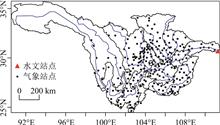
Based on the data of daily precipitation of 271 meteorological stations in the upper reaches of the Yangtze River and the data of the Three Gorges Reservoir inflows during 1961-2017, this study analyzed the influence of precipitation in the upper reaches of the Yangtze River on the inflow of the Three Gorges Reservoir by using t-test, synthetic analysis, correlation analysis, and cluster analysis. The results show that: 1) The precipitation in August and September has the greatest influence on the key monthly inflow of the Three Gorges Reservoir. 2) According to the precipitation characteristics, the upper reaches of the Yangtze River can be divided into six zones, in which the regions along and in the south of the Yangtze River is divided based on the natural watersheds: Zone I (the south of the Jialing River), Zone II (the upper reaches of the Jinsha River, the north of the Mintuojiang River, and the north of the Jialing River), Zone III (Chongqing-Yichang), Zone IV (the Wu River), Zone V (Yibin-Chongqing), and Zone VI (the middle and lower reaches of the Jinsha River). 3) The contributions of the six zones to the key monthly inflow of the Three Gorges Reservoir are as follow: with the largest precipitation and the shortest catchment distance, Zone I and Zone III have the greatest contribution in these six zones; Zone II has sparse and unevenly distributed stations, and due to the lowest precipitation and longest catchment distance, it makes the least contribution; and the remaining three zones (Zone IV, V, and VI ) make similar contributions. 4) The analysis on the three great floods with peak flow over 50000 m3/s since the Three Gorges Reservoir began to fill in 2003 finds that the continuous heavy precipitation in Zone I during 11 to 18 September 2014 and the intermittent heavy precipitation in Zone III were the root causes for the occurrence of the super food with peak flow exceeding 50000 m3/s. It also proves that the result drawn by analyzing the influence of the contribution of the precipitation in Zone I and Zone III is reliable and can provide references for the rational dispatching of water storage in the Three Gorges Reservoir.
The gauge-based precipitation data from the National Climate Center, China Meteorological Administ-ration (CMA), Asian Precipitation-Highly-Resolved Observational Data Integration Towards Evaluation (APHRODITE), Precipitation Estimation from Remotely Sensed Information using Artificial Neural Network-Climate Data Record (PERSIANN-CDR), Global Precipitation Measurement (GPM), Global Land Data Assimilation System (GLDAS), High Asia Refined analysis (HAR) are compared with each other and evaluated by the precipitation data from 16 national meteorological stations during 1980-2016 in the Yarlung Zangbo River and its sub-basins. The potential utilities of these multiple precipitation datasets are then systematically evaluated as inputs for the variable infiltration capacity (VIC) macroscale land surface hydrologic model. The results show that: 1) PERSIANN-CDR and GLDAS contain the largest precipitation estimates among the six datasets with mean annual precipitation of 770-790 mm, followed by the HAR and GPM (650-660 mm), while CMA and APHRODITE contain the lowest precipitation estimates with mean annual precipitation of 460-500 mm. All the products can detect the large-scale monsoon-dominated precipitation regime in the Yarlung Zangbo River and its sub-basins with 70%-90% of annual total precipitation occurring in June-September except the GPM. 2) The general spatial pattern of the annual mean precipitation fields is roughly in agreement among the six datasets, with a decreasing trend from the southeast to the northwest in the Yarlung Zangbo River Basin except the PERSIANN-CDR and GLDAS. 3) Relative to the data from the national meteorological stations, APHRODITE, GPM, and HAR generally underestimate precipitation by 10%-30%, while PERSIANN-CDR and GLDAS overestimate precipitation from stations in upstream sub-basins by 28%-60% and underestimate precipitation from stations in downstream sub-basins by 11%-21%. 4) The six precipitation datasets cannot satisfy the needs of hydrological simulation in term of accuracy or period in the basin. 5) HAR precipitation data—output of regional climate model—show more reasonable amount and seasonal pattern among the six datasets in the upper Brahmaputra according to the inverse evaluation by VIC hydrological model.
A collection system for paleoclimate research documents (CSPD) was developed in this study using Python (V3.6) and MySQL (V5.7) on the Linux platform. Meanwhile, 1450 research papers of paleoclimate from the National Climate Data Center (NCDC) were manually selected. The keywords from these papers were classified and, then, a keyword list for the research paper collection was prepared. Using the CSPD with the keyword list, we collected 32493 paleoclimate research papers from ResearchGate. To verify the validity of CSPD with the keyword list, we counted the frequencies of four categories of keywords from the 32493 paleoclimate research papers from ResearchGate and from the 1450 papers from NCDC, respectively. Then, the frequencies from the two document datasets were compared. The four categories of keywords refer to the dimensions of temporal scale, type of proxy data, meteorology factors, and study area. We found that the frequencies of the four categories of keywords match well for the two document datasets. This result suggests that the CSPD together with the keyword list is a valid method and the resulting document dataset represents the status of paleoclimate research. A large number of paleoclimate research documents from ResearchGate would work as a great source of paleoclimate reconstruction results, which have not been fully included by NCDC. The CSPD reached the design objective.
Rural tourism development led to a process of rapid change and reconstruction of rural communities. Social space theory provides a new paradigm for understanding these phenomena. However, Chinese research of social space in tourism is generally in the stage of introduction, mainly focusing on the analysis of spatial production process and failing to link the spatial production process with power relations and power production and reproduction from the perspective of power-space interaction. One of the cores of social space theory is the interaction between power and space, while the territorialization theory endogenous of human geography is an important perspective to analyze the power-space relationship in the real world. Therefore, taking Qinghutang Village of the Danxia Mountain as an example, this study analyzed how the multiple stakeholders of rural tourism community promote the transformation of social space using the territorialization theory focusing on power-space relations, and further summarized the power-space relationships intertwined in this process and the mechanism of social space change. Through the analysis of Qinghutang Village, this study found that local residents, management committee of Mount Danxia, and tourism capital territorialized around the space of Qinghutang Village with the rapid tourism development in the Danxia Mountain. The local residents built a relatively independent territory for tourism development through the exchange of land resources. The management committee expanded the administrative territory to the community by means of transferring land property and controlling the settlement, while the tourism capital built the market territory through the transformation of land ownership and construction of tourism consumption space. It is the reconstruction of the power relationship pattern that promoted the transformation of the social space of Qinghutang Village. In this process, the implementation of powers is subject to the manipulation and control of the community spaces by the subjects of power, that is, through territorialization. It is in the process of territorialization that power used spaces to enter the core of community life and production, and promoted the reconstruction of tourism community through the reproduction of spaces. This article argues that the social spatial change of rural tourism community is a continuous process of territorialization, which is caused by the interaction between "social organization of territory" and "territorial organization of the society". The multiple stakeholders in the rural tourism community construct the corresponding territory, and then implement their own powers within the relatively clear territory.The intervention of new powers and the construction of new territories will break the existing power relationship pattern and territory structure, leading to the transformation of social space. In this process, whether it is top-down governance power or bottom-up resistance power, real control can only be realized through the spatialization of territories construction, and powers have been spatialized in the process of territorialization, and also achieved its own production and reproduction. The analysis based on territorialization has important implications for the practice of property rights systems in tourism communities and the tourism space governance.
Based on the European Control (EC) estimation model and using aircraft configuration ratio and flight stages as impact parameters, this study estimated the time delay cost and the total time delay cost of Chinese hub airports in 24 hours with the improved EC estimation model. Then the air routes effect of time delay cost was analyzed and a comparison with the United States was carried out. The conclusions are as follows: 1) Time delay cost of the compound hub airports is generally higher than that of the regional hub airports while per minute delay cost and gating cost of regional hub airports are higher. This is caused by the centrality of the network structure of air routes, the need of aero geographic market, and the influence on the transmission efficiency of the aviation network in China. The air maintenance cost of hub airports accounts for the largest proportion of the total cost of time delay, which indicates that there are defects in the configuration of air corridors in China. 2) The spatial heterogeneity of the total cost of time delay between hub airports (air routes) and hub airport to non-hub airport (air routes) is caused by air route attributes, which are determined by the joint action of geographic market demand and the location of participating airports in air-corridors in the sky. The specific performance is affected by the difference of clustering levels: the hub and non-hub airports (air routes) generally exist in the low level, and the hub airports (air routes) basically exist in the high level. There is a significant difference in the total cost of time delay between the compound hub airports and the regional hub airports. The three routes in the fifth level clustering connect PEK, SHA, CAN, which is dominated by the aero geographic market, and the total cost of time delay accounts for 9.22% of the total cost of all routes in 24 hours. Among the total cost of time delay between hub airport and non-hub airport (air routes), PEK-SZX is the highest, followed by SHA-NKG. 3) The difference in time delay cost of hub airports and air routes between China and the United States is mainly manifested in the different proportion of the flight stages, which is determined by the width of characteristic path and the number of track intersections in air corridors in the sky.
In recent years, with the rapid development of marine transportation and port logistics and international trade, the traffic density and flow of ships at sea are increasing, which brings many challenges to the safety of maritime navigation and marine ecological environment. The application of Automatic Identification System (AIS) technology provides a good data source for maritime traffic management and marine spatial planning. Based on the AIS data of the Bohai Sea in 2018 with data quality control and sampling processing, this study analyzed the traffic characteristics of the Bohai Sea. By means of mathematical statistics and Geographic Information System (GIS) spatial analysis, the spatial distribution characteristics such as ship position and density, ship speed and the temporal characteristics of daily, monthly, and seasonal changes of ship flow in the Bohai Sea were analyzed in order to reveal the spatial-temporal variations of ship activities in the Bohai Sea. The influencing factors of the spatio-temporal distribution of maritime ship activities were also discussed. The results show that: 1) Fishing ships were mostly located in the offshore area, which were agglomerated. Commercial ships were mostly gathered in the common area, which were distributed in belts. The number of cargo ships accounted for 78.58% of commercial ships and they were mainly medium-sized cargo ships, and passenger ships and oil tankers were mainly small and medium-sized ships. 2) Speed of the ships was mainly medium and low, especially fishery ships. The ships with higher speed were mainly large and medium-sized freighters and passenger ships. 3) The activity time and seasonal change characteristics of fishery ships were significant, and activities were more frequent after the end of the fishing moratorium and during the daytime. Compared with fishery ships, the activities of commercial ships in the Bohai Sea were less affected by seasonal changes and day and night alternation. It is found that the Bohai Sea traffic flow density was high, ships met frequently, and the risk of ship collision and major pollution accidents increased through the study period. There is a large conflict between the east-west and south-north marine traffic and fishing ships in the utilization of maritime space, and more attention needs to be paid to this conflict. Natural environmental and resource conditions, coastal socioeconomic development and port construction, regulation of the sea, and other factors affect the spatio-temporal distribution of marine ships.
Neuroscience is the science of the 21st century. The theoretical research results of neuroscience are affecting daily life, environment, space, context, and place profoundly. It provides a new way of thinking and method to explain human's mind and behavior. In the context of post-modernism, the understanding of self-consciousness in human geography has become fragmented. Non-presentation theory and embodied cognitive geography claim that in most of the time, people are "unconscious". Subject self-consciousness is irrational, which takes place in the "outflows" daily life world. It emphasizes the showing, performance, and practice of the body. The meaning of the real world should be obtained through embodied cognition and behavior. They found evidence from neuroscience that led to a "neural turn" in geography. The "neural turn" devotes to linking human's mind and behavioral traits to biological evidence. It is different from inter-disciplinary debates that are breaking down the disciplinary boundaries between social culture and natural sciences. The laboratory methods cannot reflect the real world, and the social science methods are difficult to get rid of subjective factors. The "neural turn" can provide a research perspective of combining the-first-person and the-third-person for human geography. This article reviewed the recent studies on the "neural turn" in Western human geography. "Neural turn" research mainly concentrated in three aspects: space perception, embodied affect, and behavior practice. It has involved economic, political, social, cultural, public policy, tourism, and education topics. The application of neuroscience in human geography can also be applied to multiple scales of space such as country, city, community, and body. Neuroscience perspective as a new path is used in urban planning, environmental design, tourism development, and public policy, among others. At the same time, the technical tools of neuroscience have become new data collection methods in human geography. Neural technology can capture imperceptible physiological changes in the human body in order to detect neural activity caused by mind and behavior in a particular environment and context. The collection of physiological data can surmount the representation of text and symbols to discover non-representational results. Brain images and eye tracking technologies have been applied in geography, presenting predictable visions for the future. At present, Chinese human geography pays little attention to neuroscience. This article is hoped to provide some reference and enlightenment for the study of Chinese human geography. The dialogue between neuroscience and human geography is still in its infancy and needs more empirical research. In this process, human geography can carry out more cooperative research to produce more knowledge spillover. At the same time, these studies need to explore the topic of Chinese localization in order to better realize the people-oriented approach in the research and application of Chinese human geography.
After the global financial crisis in 2008, many countries around the world have made great efforts to create a sustainable future, and green development has been seen as the most important pathway to sustainability. As a new research perspective in the area of sustainable development, green development has drawn great attention from academic researchers globally in recent years and has become interdisciplinary-oriented. As an applied basic research field for exploring the structural change of resources and environment and regional sustainable development, geography plays an essential role in the research of green development. Based on an intensive literature review, this article summarized the connotation and analytical framework of green development at first, then systematically outlined the progress of green development research from the perspective of geography and extracted seven themes, that is, the influencing factors of green development, assessment methods, spatial and temporal characteristics of green development, green development and industrial transformation, green transformation of resource-based cities, the effect of green development, and green development institutions and recommendations. Comments were made on the existing studies and shortcomings of existing research were analyzed. Finally, future research emphases were discussed, with the aim to provide references for studying green development from the perspective of geography in China.
China has witnessed a mass migration and mobility movement over the past four decades. Although a plethora of literature has studied the motivations, characteristics, and effects of residential mobility, little research has been done to reveal the impact of residential mobility on heath in urban China. Thus, this study combined the method of knowledge map analysis and traditional literature research analysis to review existing studies from 2004-2018 in the Web of Science database, to provide suggestions for promoting such research in China. A total of 338 papers in Web of Science on "residential mobility and health" in related fields was extracted and visually analyzed by VOSviewer. The results and conclusions are as follows. First, the influence of residential mobility on residents' health has drawn growing attention in the recent 15 years, evidenced by the increasing number of published articles, especially in the field of geography, urban planning, and environment studies. Spatial distribution of outputs was mainly concentrated in the developed countries. However, the research contents significantly differed between the United Stated and Europe. Second, the main research subjects have shifted from "homogeneity within groups" to "heterogeneity within groups", and from "common subjects" to "specific subjects" (for example, children, women, and the eldlies). On the other hand, quantitative methods, particularly cross-sectional analysis of individuals, were widely used in the early period, while mixed research methods (qualitative and quantitative) and longitudinal analysis of linked lives were adopted in follow-up studies. In terms of measurement indicators, 53% of papers selected "stress" and "depression" to estimate mental health; 32% of papers used "birth weight", "perinatal mortality", and so on as physical health outcomes, followed by "all-cause mortality rate"(16%), "obesity"(14%), and "BMI"(10%). Residential mobility indicators referred to three aspects: life course factors (personal biographies, work and housing transitions, life events), spatial and temporal factors (moving frequency, distance, location, and direction, and so on), and mobility motivations (voluntary or forced). Third, in terms of theoretical evolution, it has undergone three stages: "migration-health" from a macro (general mobility) perspective at the early stage, "residential mobility-environment-health" from a micro (individual) perspective at the second stage, and "mobility trajectory-environment change-health development" from a mobility (a range of mobility categorizations and time scales) perspective at the third stage. Fourth, based on the result of cluster analysis, four main topics were identified: 1) Disadvantaged neighborhood, instability of family structure, and vulnerable school networks led by frequent mobility would influence children's health. Children with different demographic profiles responded differently to the social contexts in which they were exposed (age-dependent neighborhood effect). 2) There were uncertainty in the spatial and temporal features of residential mobility impact on physical and mental health. 3) Diverse housing career factors (facility index, crowding rate, renting cost, and so on), on the one hand, can directly influence physical and mental health. On the other hand, they can be moderated by perceived stress to affect health indirectly. 4) Frequent mobility can result in the cumulative effect of neighborhood environment, and long-term neighborhood deprivation would induce disease risks. Finally, through a critical re-thinking of existing research in China, this article suggests that we should realize interdisciplinary analysis, and focus on the impact of intra-urban residential mobility as well as mobility trajectory on residents' health. More importantly, researchers need to explore further the mediating factors (for example, residential segregation, social differentiation, jobs-housing imbalance, and son on) and keep a close watch on the health development of migrant children living in the informal residential spaces (urban village).
Designing hyetographs is the basis of deducing design flood for small and medium-sized watersheds lacking flow data. It has a significant impact on construction standards of water conservancy facilities and municipal engineering design. Therefore, a large number of studies on design hyetograph has been carried out in China and internationally. In recent years, due to the impact of climate and environmental changes, great floods occur frequently. Mountain floods and waterlogging in urban areas pose a threat to the property and personal safety of mountain people and urban residents, and have caused many disasters. Therefore, higher requirements are put forward for the design of hyetographs. This article systematically summarized the principles and methods for selecting typical hyetographs and the classification of hyetographs, and reviewed the methods of deducing hyetographs in China and abroad, including the Chicago Hyetographs, the Huff Hyetographs, the Triangle Rainfall Hyetographs, and the Pilgrim & Cordery (P&C) Hyetographs—our short-duration design hyetographs in total, as well as the long-duration Soil Conservation Service (SCS) Hyetographs and the same-frequency method. Finally, the problems in designing hyetographs in small and medium-sized watersheds and the prospects for future research are put forward.
The dike-pond system is a way of low-lying land use and a circular ecological agriculture model created by the Chinese people. The dike-pond system of the Pearl River Delta has played an important role in history, but its area is shrinking and the ecological function is degrading. In order to promote the protection of traditional agriculture cultural heritage in the Pearl River Delta and facilitate the coordinated development of regional human-land relations, this study used the bibliometrics method to examine and summarize the research literature of the system in the Pearl River Delta region. The result shows that scholars have carried out studies by focusing on the productivity of the dike (field)-pond system, the pattern of regional water and land ecological agriculture cycles, and the relationship between social economic development and the protection of traditional agriculture cultural heritage, among others. However, the research on the mechanism of change of the dike-pond system in the Pearl River Delta is relatively weak, and the exploration of agriculture cultural heritage protection methods with regional characteristics is still rarely recorded. Consequently, it is suggested that further in-depth studies are needed for the evolution mechanism and reconstruction technologies of the dike-pond system and protection value and approaches of agriculture cultural heritage in the Pearl River Delta in the future. In this way, the theoretical and practical research of the dike-pond system will contribute to providing support for the coordinated relationship between the coupled agricultural production and ecological systems.